
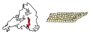
Blount County is a county located in the East Tennessee Grand Division of the U.S. state of Tennessee. As of the 2020 census, its population was 135,280. The county seat is Maryville, which is also the county's largest city. Blount County is included in the Knoxville metropolitan area.

Swain County is a county located on the far western border of the U.S. state of North Carolina. As of the 2020 census, the population was 14,117. Its county seat is Bryson City.

Graham County is a county located in the U.S. state of North Carolina. As of the 2020 census, the population was 8,030, making it the third-least populous county in North Carolina. Its county seat is Robbinsville.

Cherokee County is the westernmost county in the U.S. state of North Carolina. It borders Tennessee to its west and Georgia to its south. As of the 2020 census, the population was 28,774. The county seat is Murphy.

Lake Santeetlah is a town in Graham County, North Carolina, United States, 6 miles (10 km) northwest of Robbinsville on a peninsula surrounded by Lake Santeetlah—which in turn is largely surrounded by Nantahala National Forest. The town has more than two hundred residences, many of them second homes owned by permanent residents of Florida and Georgia. The town was organized in 1989 as "Santeetlah"; in 1999, it changed its name to "Lake Santeetlah". The full-time population was 67 at the 2000 census and dropped to 45 in 2010.

Dillsboro is a town in Jackson County, North Carolina, United States. The population was 232 at the 2010 census.

Badin is a town located in Stanly County, North Carolina, United States. At the 2010 census, the town had a total population of 1,974.

Bryson City is a town in and the county seat of Swain County, North Carolina, United States. The population was 1,558 as of the 2020 census. Located in what was historically the land of the Cherokee, Bryson City was founded as Charleston to serve as the county seat of Swain County when it was formed from parts of surrounding counties. It grew into an important local rail hub. Today the city serves as a popular tourist destination, lying just to the west of the entrance to the Great Smoky Mountains National Park, for outdoor activities in the Nantahala National Forest, and along the Nantahala River and Fontana Lake, and serves as the home of the Great Smoky Mountains Railroad, a heritage railroad that provides tours of the Nantahala valley. The popular Nantahala Outdoor Center provides guide services for many of the outdoor activities in the area.
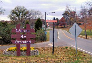
Greenback is a city in Loudon County, Tennessee, United States. Its population was at 1,102, according to the 2020 census. It is included in the Knoxville Metropolitan Statistical Area.

The Little Tennessee River is a 135-mile (217 km) tributary of the Tennessee River that flows through the Blue Ridge Mountains from Georgia, into North Carolina, and then into Tennessee, in the southeastern United States. It drains portions of three national forests— Chattahoochee, Nantahala, and Cherokee— and provides the southwestern boundary of the Great Smoky Mountains National Park.

Roland A. Wank (1898–1970) was a Hungarian-American modernist architect, best known for his work for the Tennessee Valley Authority in the United States.
Tellico Village is an unincorporated planned community, and census-designated place on the western shore of Tellico Reservoir in Loudon County, Tennessee, United States, about 30 miles (48 km) southwest of Knoxville. Its population was 5,791 as of the 2010 census and and 7,311 at the 2020 census. Tellico Village is the second largest area by population in Loudon County behind Lenoir City.

Fontana Dam is a hydroelectric dam on the Little Tennessee River in Swain and Graham counties, North Carolina, United States. The dam is operated by the Tennessee Valley Authority, which built the dam in the early 1940s to satisfy the skyrocketing electricity demands in the Tennessee Valley to support the aluminum industry at the height of World War II; it also provided electricity to a formerly rural area.
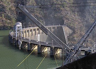
Calderwood Dam is a hydroelectric dam located along the Little Tennessee River in Blount and Monroe counties, in the U. S. state of Tennessee. Completed in 1930, the dam is owned and maintained by Tapoco, a subsidiary of the Aluminum Company of America (Alcoa), although the Tennessee Valley Authority (TVA) controls the dam's reservoir levels from Fontana Dam further upstream. Calderwood Dam is named for Alcoa engineer Isaac Glidden Calderwood (1871–1941), who supervised much of the company's early Little Tennessee River operations.

The Cheoah Dam is a hydroelectric dam located in Graham and Swain counties, North Carolina, on the Little Tennessee River between river miles 51 and 52. The Cheoah Development consists of a dam and powerhouse, the first of several constructed by the Tallassee Power Company, a subsidiary of Aluminum Company of America, in order to generate electricity to smelt aluminum in Alcoa, Tennessee.

Chilhowee Dam is a hydroelectric dam located in Blount and Monroe counties, Tennessee, United States, between river mile 33 and 34 on the Little Tennessee River. Construction by the Tennessee Valley Authority (TVA) began in 1955 and was completed in 1957. The dam's reservoir covers approximately 1,734 acres (702 ha) at normal full pool and has a drainage area of 1,977 square miles (5,120 km2). The elevation of Chilhowee Reservoir is 874 feet (266 m) above mean sea level (USGS). Chilhowee's powerhouse is equipped with three Kaplan turbines that have a combined generating capacity of 48 megawatts.

Walland is an unincorporated community and census-designated place (CDP) in Blount County, Tennessee. Its population was 281 as of the 2020 census. Walland is the site of a post office and is the place name associated with zip code 37886, which covers an area beyond the Walland community.
Alcoa Power Generating, Inc. is a subsidiary of Alcoa Inc., headquartered in Pittsburgh, Pennsylvania. Its three divisions were independent subsidiaries before being consolidated into Alcoa Power Generating, Inc. (APGI). These three projects have produced hydroelectric power and manage impoundments which also provide flood control; recreation, residential and business opportunities; and wildlife habitat.
Almond is an unincorporated community in Swain County, North Carolina, United States. Almond is located on the Little Tennessee River and North Carolina Highway 28 7.9 miles (12.7 km) west-southwest of Bryson City.
Caroleen is an unincorporated community and census-designated place (CDP) in southeastern Rutherford County, North Carolina, United States. Its population was 652 as of the 2010 census. Caroleen has a post office with ZIP code 28019. U.S. Route 221 Alternate passes through the community.


