
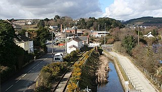
The Forgotten Corner of Cornwall is a geographical area of South East Cornwall, Great Britain. It includes the Rame Peninsula and the town of Torpoint, as well as villages like Antony, Downderry, Polbathic, Portwrinkle and Widegates.
The Forgotten Corner of Cornwall is a geographical area of South East Cornwall, Great Britain. It includes the Rame Peninsula and the town of Torpoint, as well as villages like Antony, Downderry, Polbathic, Portwrinkle and Widegates.
There is no precise geographical definition for the "corner", but it is taken to mean (by local residents) all of the Rame Peninsula, as well as all of the English Channel coast area to the east of (but not including) Looe. [1] The northern boundary of the corner is defined by the A38 road.
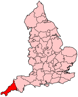
It is reputed to be "forgotten" because the area is effectively by-passed Cornwall visitors, and is geographically remote from the administrative headquarters of Cornwall at Truro. [2] It is over 50 miles away from the Cornish capital.
It is isolated due to its geography, as it is bounded by the English Channel, Plymouth Sound, the River Tamar and the River Lynher. Visitors have to double back on themselves after taking the main A38 road from Plymouth at Trerulefoot and onto the A374. There are no main railway stations within the area; the nearest is at St Germans, which has a limited train service. However, there is a frequent vehicular ferry to Torpoint from Plymouth, and a passenger ferry to Cremyll from Stonehouse, Plymouth. There is also a passenger ferry from Plymouth to Cawsand in the summer.
The area effectively became more remote when the then new Saltash Road Bridge on the A38 road was opened in 1961. Before the opening of this bridge, and the improvements to the A30 road from Exeter to Penzance, most road traffic entered Cornwall using the Torpoint Ferry, taking visitors directly into this area. After the bridge opened, and continued dual carriageway improvements were made on the A30 road, traffic travelling through this part of Cornwall reduced greatly.
The Rame Peninsula part of the Forgotten Corner is included in the Cornwall Area of Outstanding Natural Beauty. [3] It is also steeped in history, with many military forts, and archaeological points of interest. [4] The area is essentially rural, with the main industry being agriculture. It is also a residential commuting area for Plymouth. The area also has some of the wealthiest areas within Cornwall, as well as some of the poorest. [5]
Historical note: Until boundary reform in the 19th century parts of the Rame Peninsula formed part of Devon as the manors had been possessions of Tavistock Abbey from Norman times.
Places in the district include: Antony, Cawsand, Crafthole, Cremyll, Downderry, Fourlanesend, Freathy, Hessenford, Higher Wilcove, Kingsand, Lower Tregantle, Maker, Millbrook, Mount Edgcumbe House, Mount Edgcumbe Country Park, Penlee, Polbathic, Portwrinkle, Rame, Rame Head, Rame Peninsula, Seaton, Seaton Valley Countryside Park, Sheviock, St John, Torpoint, Whitsand Bay, Widegates, and Withnoe Barton.
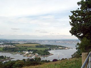
The Hamoaze is an estuarine stretch of the English tidal River Tamar, between its confluence with the River Lynher and Plymouth Sound.

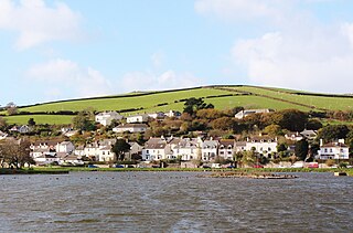
Cawsand and Kingsand are twin villages in southeast Cornwall, England, United Kingdom. The village is situated on the Rame Peninsula and is in the parish of Maker-with-Rame.
Millbrook is a civil parish and village in southeast Cornwall, England, United Kingdom. The village is situated on the Rame Peninsula four miles (6.5 km) south of Saltash. The population of Millbrook was 2,033 in the 2001 census, increasing to 2,214 at the 2011 census.
The Rame Peninsula is a peninsula in south-east Cornwall. It is surrounded by the English Channel to the south, Plymouth Sound to the east, the Hamoaze to the northeast and the estuary of the River Lynher to the north-west. On a clear day, the Atlantic Ocean can be seen from advantageous points from Rame Head. The largest settlement is Torpoint, which is on the eastern coast, facing Devonport in Plymouth, Devon.

Kingsand and Cawsand are twin villages in southeast Cornwall, United Kingdom. The villages are situated on the Rame Peninsula and are in the parish of Maker-with-Rame.

Mount Edgcumbe House is a stately home in south-east Cornwall and is a Grade II listed building, whilst its gardens and parkland are listed as Grade I in the Register of Parks and Gardens of Special Historic Interest in England.
Cremyll is a small coastal village in south-east Cornwall, England, United Kingdom. Cremyll is on the Rame Peninsula facing Plymouth Sound. The village is about 9 miles by road or 0.5 miles by boat from Plymouth. It is in the civil parish of Maker-with-Rame.
Mount Edgcumbe Country Park is listed as Grade I on the National Register of Historic Parks and Gardens and is one of four designated country parks in Cornwall, England, United Kingdom. The 885 acres (3.58 km2) country park is on the Rame Peninsula, overlooking Plymouth Sound and the River Tamar. The park has been famous since the 18th century, when the Edgcumbe family created formal gardens, temples, follies and woodlands around the Tudor house. Specimen trees, such as Sequoiadendron giganteum, stand against copses which shelter a herd of wild fallow deer. The South West Coast Path runs through the park for nine miles (14 km) along the coastline.

Maker is a village between Cawsand and Rame Head, Rame Peninsula, Cornwall, England, United Kingdom.
Maker-with-Rame is a civil parish in Cornwall, England, United Kingdom. It is situated on the Rame Peninsula, approximately four miles (6.5 km) south of Saltash and two miles (3 km) west of Plymouth.
The evolution of transport in Cornwall has been shaped by the county's strong maritime, mining and industrial traditions and much of the transport infrastructure reflects this heritage.
St John is a coastal civil parish and a village in south-east Cornwall, England, United Kingdom, 3 miles (4.8 km) south of Saltash and 1.5 miles (2.4 km) south-west of Torpoint.

The A374 is a main road in the United Kingdom, one of six A-roads making the border crossing between Devon and Cornwall. It is the most southerly of the A37x group of roads, starting and ending its journey with the A38 trunk road, from the outskirts of Plymouth in Devon to the Trerulefoot roundabout in Cornwall.
The Millbrook Steamboat & Trading Company was a ferry operator on the River Tamar between Devon and Cornwall in England. It was started in 1894, and initially operated a ferry route from Millbrook in Cornwall to Plymouth. It expanded, and eventually became the largest river boat operator in the Plymouth area. From 1943 it operated the Cremyll Ferry.

The Cremyll Ferry is a foot passenger ferry across the Hamoaze from Admirals Hard in Stonehouse, Plymouth, Devon to Cremyll in Cornwall. It is operated by Plymouth Boat Trips, and runs approximately every 30 minutes, with an 8-minute crossing time.
The following outline is provided as an overview of and topical guide to Cornwall: Cornwall – ceremonial county and unitary authority area of England within the United Kingdom. Cornwall is a peninsula bordered to the north and west by the Celtic Sea, to the south by the English Channel, and to the east by the county of Devon, over the River Tamar. Cornwall is also a royal duchy of the United Kingdom. It has an estimated population of half a million and it has its own distinctive history and culture.
Presented below is an alphabetical index of articles related to Cornwall:

St Paul's Church is a former Church of England church in Kingsand, Cornwall, England, UK. Built in 1881–82, the church ceased use as a place of worship after 1943 and is now used as the Maker with Rame Community Hall.

Rame Peninsula was an electoral division of Cornwall in the United Kingdom which returned one member to sit on Cornwall Council from 2013 to 2021. It was abolished at the 2021 local elections, being succeeded by Rame Peninsula and St Germans.
| Unitary authorities | |
|---|---|
| Major settlements (cities in italics) |
|
| Rivers | |
| Topics | |