
Spokane County is a county located in the U.S. state of Washington. As of the 2020 census, its population was 539,339, making it the fourth-most populous county in Washington. The largest city and county seat is Spokane, the second largest city in the state after Seattle. The county is named after the Spokane people.

Kootenai County is located in the U.S. state of Idaho. As of the 2020 census, its population was 171,362, making it the third-most populous county in Idaho and the largest in North Idaho, the county accounting for 45.4% of the region's total population. The county seat and largest city is Coeur d'Alene. The county was established in 1864 and named after the Kootenai tribe. Kootenai County is coterminous with the Coeur d'Alene metropolitan area, which along with the Spokane metropolitan area comprises the Spokane–Coeur d'Alene combined statistical area.

Post Falls is a city in Kootenai County, Idaho, United States. It is the gateway city to Northern Idaho off Interstate 90, just west of Coeur d'Alene, and east of Spokane, Washington. The population was 38,485 at the 2020 census, making it Idaho's ninth-largest city and the second largest city in North Idaho behind Coeur d’Alene.

Coeur d'Alene is a city and the county seat of Kootenai County, Idaho, United States. It is the most populous city in North Idaho and the principal city of the Coeur d'Alene Metropolitan Statistical Area. The population was 54,628 at the 2020 census. Coeur d'Alene is a satellite city of Spokane, which is located about thirty miles (50 km) to the west in the state of Washington. The two cities are the key components of the Spokane–Coeur d'Alene Combined Statistical Area, of which Coeur d'Alene is the third-largest city. The city is situated on the north shore of the 25-mile (40 km) long Lake Coeur d'Alene and to the west of the Coeur d'Alene Mountains. Locally, Coeur d'Alene is known as the "Lake City", or simply called by its initials, "CDA".

Hayden is a city in Kootenai County, Idaho, United States. Located in the northern portion of the state, it is a suburb of nearby Coeur d'Alene and its population was 15,570 at the 2020 census.

Cheney is a city in Spokane County, Washington, United States. The full-time resident population was 13,255 as of the 2020 census. Eastern Washington University is located in Cheney. When classes are in session at EWU, the city's population reaches approximately 17,600 people temporarily.

Liberty Lake is a city in Spokane County, Washington, United States, located adjacent to the eponymous lake. Located just over a mile west of the Washington–Idaho border, Liberty Lake is both a suburb of Spokane, Washington and a bedroom community to Coeur d'Alene, Idaho. The population was 12,003 at the 2020 census.

Spokane is the most populous city in eastern Washington and the county seat of Spokane County, Washington, United States. It lies along the Spokane River, adjacent to the Selkirk Mountains, and west of the Rocky Mountain foothills, 92 miles (148 km) south of the Canadian border, 18.5 miles (30 km) west of the Washington–Idaho border, and 279 miles (449 km) east of Seattle, along Interstate 90.

Spokane Valley is a city in Spokane County, Washington, United States, and the largest suburb of Spokane. It is located east of Spokane, west of Coeur d'Alene, Idaho, and surrounds the city of Millwood on three sides. The city incorporated as the City of Spokane Valley on March 31, 2003. The population was 102,976 at the 2020 census, making it the ninth-most populous city in Washington state. Spokane Valley is named after the valley of the Spokane River, in which it is located. The city and the general area is colloquially referred to as "The Valley" by residents of the Spokane–Coeur d'Alene area.
The Inland Northwest, historically and alternatively known as the Inland Empire, is a region of the American Northwest centered on the Greater Spokane, Washington Area, encompassing all of Eastern Washington and North Idaho. Under broader definitions, Northeastern Oregon and Western Montana may be included in the Inland Northwest. Alternatively, stricter definitions may exclude Central Washington and Idaho County, Idaho.

The Coeur d'Alene Tribe are a Native American tribe and one of five federally recognized tribes in the state of Idaho. The Coeur d'Alene have sovereign control of their Coeur d'Alene Reservation, which includes a significant portion of Lake Coeur d'Alene and its submerged lands.

The Spokane Valley is a valley of the Spokane River through the southern Selkirk Mountains in the U.S. state of Washington. The valley is home to the cities of Spokane and its suburbs Spokane Valley, Liberty Lake, and Millwood. The valley is bounded on the north and south by the Selkirk Mountains, on the west by the Columbia River Basalt Group, and on the east by the Rathdrum Prairie at the Idaho state border. Mica Peak, located south of the valley, is the southernmost peak in the Selkirk Range. The mountain, along with surrounding peaks, separates the Spokane Valley from the Palouse. The Valley contains part of the Spokane Valley–Rathdrum Prairie Aquifer.

Coeur d'Alene Lake, officially Coeur d'Alene Lake, is a natural dam-controlled lake in North Idaho, located in the Pacific Northwest region of the United States. At its northern end is the city of Coeur d'Alene. It spans 25 miles (40 km) in length and ranges from 1 to 3 miles (5 km) wide with over 109 miles (175 km) of shoreline.

Clarkia is a small unincorporated community in the southwestern corner of Shoshone County, Idaho. It is surrounded by publicly and privately managed forest lands of Douglas-fir, Ponderosa Pine, and Western Larch. Located just to the east of State Highway 3, the town is in the drainage area of the West Fork of the St. Maries River.

Spokane, Washington has a rich sporting culture and the area residents are active in many spectator and participant sports. Although Spokane lacks any major, nationally recognized professional sports team, Spokane has a sports friendly atmosphere, and was recognized and rated #99 in the Sporting News 2006 "99 Best Sporting Cities" list. In 2009, Sports Business Journal rated Spokane as the fifth best minor league sports market in America out of 239 markets.

The economy of the Spokane metropolitan area plays a vital role as the hub for the commercial, manufacturing, and transportation center as well as the medical, shopping, and entertainment hub of the 80,000 square miles (210,000 km2) Inland Northwest region. Although the two have opted not to merge into a single Metropolitan Statistical Area (MSA) yet, the Coeur d'Alene MSA has been combined by the Census Bureau into the Spokane–Coeur d'Alene combined statistical area (CSA). The CSA comprises the Spokane metropolitan area and the Coeur d'Alene metropolitan area anchored by Coeur d'Alene, Idaho. According to the U.S. Bureau of Labor Statistics, the Spokane metropolitan area has a workforce of about 287,000 people and an unemployment rate of 5.3 percent as of February 2020; the largest sectors for non–farm employment are education and health services, trade, transportation, and utilities, and government. The Coeur d'Alene metropolitan area has a workforce of 80,000 people and an unemployment rate of 6.8% as of June 2020; the largest sectors for non-farm employment are trade, transportation, and utilities, government, and education and health services as well as leisure and hospitality. In 2017, the Spokane–Spokane Valley metropolitan area had a gross metropolitan product of $25.5 billion while the Coeur d'Alene metropolitan area was $5.93 billion.
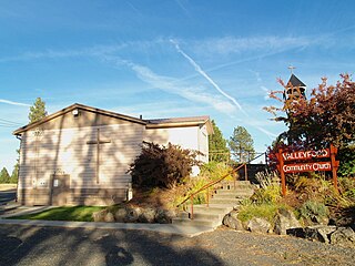
Valleyford is an unincorporated community in Spokane County, Washington, United States. Valleyford has a post office with ZIP code 99036. Valleyford was listed to have a population of 2,913 according to the 2010 United States census.
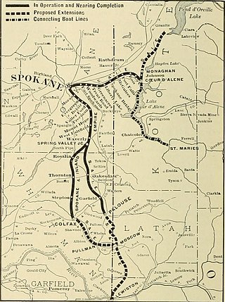
The Spokane and Inland Empire Railroad Company (S.&I.E.R.R.Co.) was an electrified interurban railway operating in Spokane, Washington and vicinity, extending into northern and central Idaho. The system originated in several predecessor roads beginning c. 1890, incorporated in 1904, and ran under its own name to 1929. It merged into the Great Northern Railway and later, the Burlington Northern Railroad, which operated some roads into the 1980s.
Spokane–Coeur d'Alene combined statistical area, officially the Spokane–Spokane Valley–Coeur d'Alene, WA–ID CSA as defined by the United States Census Bureau, is a combined statistical area that comprises the Spokane metropolitan area and the Coeur d'Alene metropolitan area. The population was 785,302 as of 2023. It is the 70th largest Combined Statistical Area in the United States, and is the economic and cultural center of the Inland Northwest. The CSA is anchored by Spokane and its largest satellite, Coeur d'Alene, which are separated by suburbs that largely follow the path of the Spokane Valley and Rathdrum Prairie.

The Spokane–Spokane Valley Metropolitan Statistical Area, as defined by the United States Census Bureau, is an area consisting of Spokane and Stevens counties in Washington state, anchored by the city of Spokane and its largest suburb, Spokane Valley. As of July 1, 2021, the MSA had an estimated population of 593,466. The Spokane Metropolitan Area and the neighboring Coeur d'Alene metropolitan area, make up the larger Spokane–Coeur d'Alene combined statistical area. The urban areas of the two MSAs largely follow the path of Interstate 90 between Spokane and Coeur d'Alene. In 2010, the Spokane–Spokane Valley MSA had a gross metropolitan product of $20.413 billion.


