Otis Orchards-East Farms, Washington

Last updated

Otis Orchards-East Farms, Washington
CDP
Spokane County Washington Incorporated and Unincorporated areas Otis Orchards-East Farms Highlighted.svg
Location of Otis Orchards-East Farms, Washington
Coordinates: 47°42′17″N117°4′48″W / 47.70472°N 117.08000°W / 47.70472; -117.08000
CountryUnited States
State Washington
County Spokane
Area
  Land8.03 sq mi (20.8 km2)
Population
 (2020)
  Total62,299
  Density784.3/sq mi (302.8/km2)
Time zone UTC-8 (Pacific (PST))
  Summer (DST) UTC-7 (PDT)
ZIP Code
99027 [1]
Area code Area code 509
FIPS code 53-52267 [2]

Otis Orchards-East Farms is a census-designated place (CDP) in Spokane County, Washington, United States, near the county's border with Idaho. The population was 6,299 at the 2020 census. The CDP includes the unincorporated communities of Otis Orchards and East Farms. Otis Orchards contains the bulk of the businesses of the community.

Contents

Otis Orchards-East Farms is north of the Spokane River from Liberty Lake, Washington and west of Rathdrum, Idaho and Stateline, Idaho. Part of Otis Orchards was recently incorporated into the new city of Spokane Valley. Otis Orchards is in the eastern part of the Spokane River valley, and is in the Spokane, Washington metro area.

Geography

Otis Orchards-East Farms CDP is located at 47°42′17″N117°4′48″W / 47.70472°N 117.08000°W / 47.70472; -117.08000 (47.704799, -117.079874). [3]

According to the United States Census Bureau, the CDP has a total area of 8.1 square miles (21.1 km2), of which, 8.1 square miles (20.8 km2) of it is land and 0.1 square miles (0.3 km2) of it (1.23%) is water.

Demographics

As of the census [2] of 2000, there were 6,318 people, 2,110 households, and 1,742 families residing in the CDP. The population density was 784.8 people per square mile (303.0/km2). There were 2,187 housing units at an average density of 271.7/sq mi (104.9/km2). The racial makeup of the CDP was 95.11% White, 1.22% Native American, 1.16% Asian, 0.17% African American, 0.05% Pacific Islander, 0.51% from other races, and 1.79% from two or more races. Hispanic or Latino of any race were 1.95% of the population.

There were 2,110 households, out of which 43.6% had children under the age of 18 living with them, 67.4% were married couples living together, 10.0% had a female householder with no husband present, and 17.4% were non-families. 13.5% of all households were made up of individuals, and 3.0% had someone living alone who was 65 years of age or older. The average household size was 2.99 and the average family size was 3.27.

In the CDP, the age distribution of the population shows 31.7% under the age of 18, 6.6% from 18 to 24, 31.8% from 25 to 44, 23.5% from 45 to 64, and 6.4% who were 65 years of age or older. The median age was 35 years. For every 100 females, there were 100.6 males. For every 100 females age 18 and over, there were 99.4 males.

The median income for a household in the CDP was $46,946, and the median income for a family was $50,457. Males had a median income of $35,926 versus $24,430 for females. The per capita income for the CDP was $17,439. About 2.6% of families and 4.2% of the population were below the poverty line, including 3.0% of those under age 18 and 14.1% of those age 65 or over.

Related Research Articles

<span class="mw-page-title-main">Spokane County, Washington</span> County in Washington, United States

Spokane County is a county located in the U.S. state of Washington. As of the 2020 census, its population was 539,339, making it the fourth-most populous county in Washington. The largest city and county seat is Spokane, the second largest city in the state after Seattle. The county is named after the Spokane tribe.

<span class="mw-page-title-main">Muscoy, California</span> Census-designated place in California, United States

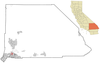
Muscoy is a census-designated place (CDP) in San Bernardino County, California, United States. The population was 10,644 at the 2010 census, up from 8,919 at the 2000 census. Muscoy shares ZIP code 92407 with the communities of Verdemont, Devore Heights, Rosena Ranch and Arrowhead Farms in northwestern San Bernardino. Residents enjoy a semi-rural setting with large lots where they can raise horses and other livestock, nursery plants, and fruit trees. For this reason, much of Muscoy is included in the county Additional Agriculture (AA) overlay, which specifies the types and quantities of animals that may be kept on each parcel. A distinctive feature of Muscoy life today is motor vehicles and equestrians sharing the roadways.

<span class="mw-page-title-main">Hauser, Idaho</span> City in Idaho, United States

Hauser is a city in Kootenai County, Idaho, United States. The population was 678 at the 2010 census. The city is located on the southern end of Hauser Lake.

<span class="mw-page-title-main">Hayden, Idaho</span> City in Idaho, United States

Hayden is a city in Kootenai County, Idaho, United States. Located in the northern portion of the state, it is a suburb of nearby Coeur d'Alene and its population was 15,570 at the 2020 census.

<span class="mw-page-title-main">Stateline, Idaho</span> City in Idaho, United States

Stateline, officially the City of State Line, and historically known as State Line Village, is a city in Kootenai County, Idaho, United States, and is both the easternmost suburb of Spokane, Washington and the westernmost suburb of Coeur d'Alene, Idaho. The population was 38 at the 2010 census. The city is known for the adult services it provides which attract business from nearby Spokane and Coeur d'Alene. The unincorporated community of Spokane Bridge, Washington is located across the Spokane River to the southwest.

<span class="mw-page-title-main">Yarmouth Port, Massachusetts</span> Census-designated place in Massachusetts, United States

Yarmouth Port is a census-designated place (CDP) in the town of Yarmouth in Barnstable County, Massachusetts, United States. The population was 5,320 at the 2010 census.

<span class="mw-page-title-main">Orchard Homes, Montana</span> CDP in Montana, United States

Orchard Homes is a census-designated place (CDP) in Missoula County, Montana, United States. It is part of the Missoula Metropolitan Statistical Area. The population was 5,377 at the 2020 census.

<span class="mw-page-title-main">Forest Oaks, North Carolina</span> Census-designated place in North Carolina, United States

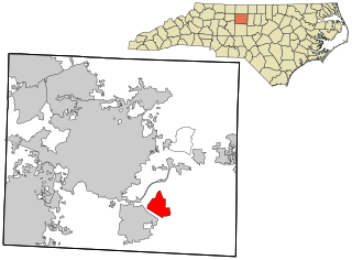
Forest Oaks is a census-designated place (CDP) in Guilford County, North Carolina, United States. The population was 3,890 as of the 2010 census, up from 3,241 in 2000.

<span class="mw-page-title-main">Orchard Hills, Pennsylvania</span> Census-designated place in Pennsylvania, United States

Orchard Hills is a census-designated place (CDP) in Armstrong County, Pennsylvania, United States. The population was 1,949 at the 2020 census.

<span class="mw-page-title-main">Gayle Mill, South Carolina</span> Census-designated place in South Carolina, United States

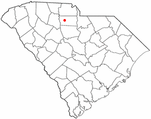
Gayle Mill is a census-designated place (CDP) in Chester County, South Carolina, United States. The population was 913 at the 2010 census, down from 1,094 at the 2000 census.

<span class="mw-page-title-main">East Port Orchard, Washington</span> CDP in Washington, United States

East Port Orchard is a census-designated place (CDP) in Kitsap County, Washington, United States. The population was 5,919 at the 2010 census.

<span class="mw-page-title-main">Airway Heights, Washington</span> City in Washington, United States

Airway Heights is a city in Spokane County, Washington, United States, just west of Spokane. The population was 10,757 at the 2020 census. The city's name was taken from its close proximity to the runways at Fairchild Air Force Base and Spokane International Airport.

<span class="mw-page-title-main">Country Homes, Washington</span> CDP in Washington, United States

Country Homes is a census-designated place (CDP) in Spokane County, Washington, United States. The population was 6,251 at the 2020 census. The campus of Whitworth University is located in Country Homes.

<span class="mw-page-title-main">Dishman, Washington</span> Locale in Washington, United States

Dishman is a locale and former census-designated place (CDP) in Spokane County, Washington, United States. Founded by Addison T. Dishman (II), who operated a nearby rock quarry in 1889, its population was 10,031 at the 2000 census. Dishman has been part of Spokane Valley since 2003.

<span class="mw-page-title-main">Fairwood, Spokane County, Washington</span> CDP in Washington, United States

Fairwood is a census-designated place (CDP) in Spokane County, Washington, United States. The population was 10,541 at the 2020 census.

<span class="mw-page-title-main">Greenacres, Washington</span> Locale in Washington, United States

Greenacres is a locale and former census-designated place (CDP) in Spokane County, Washington, United States. The locale is almost entirely split between the city of Spokane Valley and unincorporated Spokane County, with a small portion being located within the city of Liberty Lake. Greenacres retains its own post office.

<span class="mw-page-title-main">Liberty Lake, Washington</span> City in Washington, United States

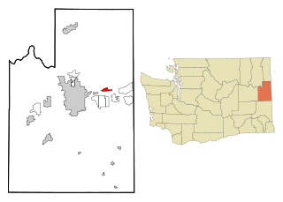
Liberty Lake is a city in Spokane County, Washington, United States located adjacent to the eponymous lake. Located just over a mile west of the Washington–Idaho border, Liberty Lake is both a suburb of Spokane, Washington and a bedroom community to Coeur d'Alene, Idaho. The population was 12,003 at the 2020 census.

<span class="mw-page-title-main">Trentwood, Washington</span> Locale in Washington, United States

Trentwood is a locale and former census-designated place (CDP) in Spokane County, Washington, United States, east across the Spokane River from Irwin. The population was 4,388 at the 2000 census. Trentwood joined the other unincorporated communities in the region to form the city of Spokane Valley in 2003.

<span class="mw-page-title-main">Veradale, Washington</span> Locale in Washington, United States

Veradale—originally known as Vera—is a locale and former census-designated place in Spokane County, Washington, United States. The population was 9,387 at the 2000 census. Veradale retains its own post office.

<span class="mw-page-title-main">Colton, Washington</span> Town in Washington, United States

Colton is a town in Whitman County, Washington, United States. The population was 418 at the 2010 census.

References

  1. "Zip Code 99027 Map". zipdatamaps.com. 2022. Retrieved November 9, 2022.
  2. 1 2 "U.S. Census website". United States Census Bureau . Retrieved January 31, 2008.
  3. "US Gazetteer files: 2010, 2000, and 1990". United States Census Bureau. February 12, 2011. Retrieved April 23, 2011.