
Cheney is a city in Spokane County, Washington, United States. The full-time resident population was 13,255 as of the 2020 census. Eastern Washington University is located in Cheney. When classes are in session at EWU, the city's population reaches approximately 17,600 people temporarily.

The Great Northern Railway was an American Class I railroad. Running from Saint Paul, Minnesota, to Seattle, Washington, it was the creation of 19th-century railroad entrepreneur James J. Hill and was developed from the Saint Paul & Pacific Railroad. The Great Northern's route was the northernmost transcontinental railroad route in the U.S.

Newport is an unincorporated community in Monroe County in the U.S. state of Michigan. The community is located within Berlin Charter Township. As an unincorporated community, Newport has no legally defined boundaries or population statistics of its own but does have its own post office with the 48166 ZIP Code.

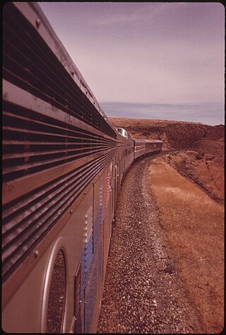
The Empire Builder is a daily long-distance passenger train operated by Amtrak between Chicago and either Seattle or Portland via two sections west of Spokane. Introduced in 1929, it was the flagship passenger train of the Great Northern Railway and was retained by Amtrak when it took over intercity rail service in 1971.

The North Coast Limited was a named passenger train operated by the Northern Pacific Railway between Chicago and Seattle via Bismarck, North Dakota. It started on April 29, 1900, and continued as a Burlington Northern Railroad train after the merger on March 2, 1970 with Great Northern Railway and the Chicago, Burlington and Quincy Railroad. The next year, it ceased operations after the trains which left their originating stations on April 30, 1971, the day before Amtrak began service, arrived at their destinations.
Homer is an unincorporated community and census-designated place (CDP) in Homer Township, Winona County, Minnesota, United States, on the south bank of the Mississippi River. As of the 2010 census, its population was 181.

Four Lakes is an unincorporated community and census-designated place in Spokane County, Washington, United States, just southwest of the city of Spokane, and north of Cheney. As of the 2010 census, its population was 512. Both Interstate 90 and SR 904 run through Four Lakes and the junction of the two is located near the center of town. Four Lakes was founded in 1879 by G.H. Morgan. The community was so named on account of there being four lakes near the original town site. It is speculated the fourth lake, is now a marsh south of Meadow Lake, which was drained by the ditch, blasted through basalt, which Minnie Creek flows through, under SR 904, south of the rodeo grounds.

The Spokane Intermodal Center is an intermodal transport facility located in Spokane, Washington, United States. It serves as a service stop for the Amtrak Empire Builder, as well as the Greyhound, Trailways, and Jefferson Lines station for Spokane. The Empire Builder provides service daily between Chicago, Illinois and Spokane before continuing on to Seattle, Washington or Portland, Oregon.

The Northern Transcon, a route operated by the BNSF Railway, traverses the most northerly route of any railroad in the western United States. This route was originally part of the Chicago, Burlington and Quincy Railroad, Northern Pacific Railway, Great Northern Railway and Spokane, Portland and Seattle Railway systems, merged into the Burlington Northern Railroad system in 1970.
Philbrook is an unincorporated community in Todd County, Minnesota, United States. It is along Todd County Road 28 near Red Pine Road. Nearby places include Staples, Motley, Cushing, and Browerville.

Norwich is an unincorporated community in western McHenry County, North Dakota, United States. It lies along U.S. Route 2 southwest of the city of Towner, the county seat of McHenry County. Norwich's elevation is 1,549 feet (472 m). It is unincorporated, and had a post office with the ZIP code of 58768. Though the post office closed May 4, 1996, the ZIP code is still valid for use.

Arvilla is an unincorporated community in central Grand Forks County, North Dakota, United States. It lies along U.S. Route 2, west of the city of Grand Forks, the county seat of Grand Forks County. Its elevation is 1,004 feet (306 m). The community was first named Orange for Orange County, New York; it was renamed Arvilla for Arvilla Estella Hersey, the wife of a local farmer. Although Arvilla is unincorporated, it has a post office, with the ZIP code of 58214.
Penn is an unincorporated community in western Ramsey County, North Dakota, United States. It lies along U.S. Route 2, northwest of the city of Devils Lake, the county seat of Ramsey County. Its elevation is 1,467 feet (447 m). The community was first named Lauren for the townsite owner, Lauren, and was later renamed Penn for English stockholders. It has a post office with the ZIP code 58362.
Vandalia is a small unincorporated community in Valley County, Montana, United States. It was established in 1904 with a post office and a store along the Hi-Line of the Great Northern Railway. The community's chief industry was the manufacture of bricks that were used in public buildings across Montana. Vandalia also shares its namesake with a local dam on the Milk River that diverts water for the Glasgow Irrigation District.

Ford is an unincorporated community in Stevens County, Washington, United States. It is on Washington State Route 231 10.5 miles (16.9 km) south-southwest of Springdale. Ford has a post office with ZIP code 99013. Ford has a nondenominational community church. A little-known historical monument commemorating the Tshimakain Mission stands just outside of the main town.
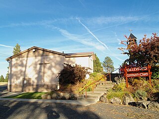
Valleyford is an unincorporated community in Spokane County, Washington, United States. Valleyford has a post office with ZIP code 99036. Valleyford was listed to have a population of 2,913 according to the 2010 United States census.
Lamoille is an unincorporated community in Richmond Township, Winona County, Minnesota, United States. Big Trout Creek and the Mississippi River meet at Lamoille.

Tyler is an unincorporated community in Spokane County, Washington, United States. Tyler is located on Washington State Route 904 near Interstate 90, 10.4 miles (16.7 km) west-southwest of Cheney.
The Expo '74 was a passenger train operated by Amtrak between Spokane and Seattle, Washington. It operated in the summer months of 1974 in coordination with its namesake, Expo '74. With the addition of the Expo '74 to the Empire Builder and North Coast Hiawatha, Amtrak provided thrice-daily service between Seattle and Spokane, the highest level seen since Amtrak's formation and unmatched since.
Galata is an unincorporated community in Toole County, Montana, United States. The community has a post office with ZIP code 59444, which opened on July 12, 1902.


