Fairwood, Spokane County, Washington

Last updated

Fairwood, Washington
CDP
Spokane County Washington Incorporated and Unincorporated areas Fairwood Highlighted.svg
Location of Fairwood, Washington
Coordinates: 47°45′53″N117°24′50″W / 47.76472°N 117.41389°W / 47.76472; -117.41389
CountryUnited States
State Washington
County Spokane
Area
  Total3.99 sq mi (10.3 km2)
  Land3.99 sq mi (10.3 km2)
  Water0.0 sq mi (0 km2)
Elevation
1,814 ft (553 m)
Population
 (2020) [1]
  Total10,541
  Density2,639.2/sq mi (1,019.0/km2)
Time zone UTC-8 (Pacific (PST))
  Summer (DST) UTC-7 (PDT)
FIPS code 53-23165 [2]
GNIS feature ID1867610 [3]

Fairwood is a census-designated place (CDP) in Spokane County, Washington, United States. The population was 10,541 at the 2020 census. [1]

Contents

Based on per capita income, one of the more reliable measures of affluence, Fairwood ranks 73rd of 522 areas in the state of Washington to be ranked.

Geography

Fairwood is located at 47°45′53″N117°24′50″W / 47.76472°N 117.41389°W / 47.76472; -117.41389 (47.764591, -117.413924). [4]

According to the United States Census Bureau, the CDP has a total area of 3.6 square miles (9.3 km2), of which, 3.6 square miles (9.3 km2) of it is land and 0.28% is water.

Fairwood is located in a lowland setting along the banks and wetlands of the Little Spokane River. The terrain falls from around 1,900 feet above sea level in the southeast to around 1,580 feet along the Little Spokane. Five Mile Prairie rises to the southwest, with a bluff climbing from the valley floor along basalt, rising almost vertically in places above Fairwood and the Little Spokane Valley before cresting at the elevation of the Columbia Plateau. To the north of Fairwood rise foothills of the Selkirk Range of the Columbia Mountains. To the south the city of Spokane sprawls into Fairwood, with the terrain sloping up as it heads into the city. [5]

Demographics

At the 2020 census, there were 10,541 people living within the CDP across 3,872 households. As of subsequent estimates by the Census Bureau from July 1, 2021, the racial makeup of the CDP was 90.9% White alone, 0.1% African American alone, 1.5% Native American alone, 3.8% Asian alone, 0.0% Pacific Islander alone, and 3.2% from two or more races. Hispanic or Latino of any race were 3.7% of the population. [1]

2000 census

As of the census [2] of 2000, there were 6,764 people, 2,474 households, and 1,964 families residing in the CDP. The population density was 1,883.0 people per square mile (727.5/km2). There were 2,560 housing units at an average density of 712.7/sq mi (275.3/km2). The racial makeup of the CDP was 94.40% White, 0.52% African American, 0.93% Native American, 1.63% Asian, 0.18% Pacific Islander, 0.47% from other races, and 1.88% from two or more races. Hispanic or Latino of any race were 2.23% of the population.

There were 2,474 households, out of which 37.9% had children under the age of 18 living with them, 68.8% were married couples living together, 8.8% had a female householder with no husband present, and 20.6% were non-families. 17.2% of all households were made up of individuals, and 9.0% had someone living alone who was 65 years of age or older. The average household size was 2.72 and the average family size was 3.07.

In the CDP, the age distribution of the population shows 27.7% under the age of 18, 7.8% from 18 to 24, 22.9% from 25 to 44, 28.7% from 45 to 64, and 12.9% who were 65 years of age or older. The median age was 40 years. For every 100 females, there were 91.1 males. For every 100 females age 18 and over, there were 89.6 males.

The median income for a household in the CDP was $59,682, and the median income for a family was $66,226. Males had a median income of $47,454 versus $31,836 for females. The per capita income for the CDP was $26,378. About 2.6% of families and 6.3% of the population were below the poverty line, including 9.0% of those under age 18 and 7.1% of those age 65 or over.

Public Transit

Fairwood is served by the Spokane area's public transit provider, the Spokane Transit Authority, which runs two fixed-route bus lines through the CDP. [6]

RouteTerminiService operation and notesStreets traveled
25
Division
Downtown Spokane
STA Plaza
Fairwood
Hastings Park and Ride
High-frequency routeNewport Highway, Hawthorne, Division
124
North Express
Downtown Spokane
STA Plaza
Fairwood
Hastings Park and Ride
Express route during peak weekday hoursWaikiki, Wall, Monroe

Related Research Articles

<span class="mw-page-title-main">Mesa, California</span> Census-designated place in California, United States

Mesa is a census-designated place (CDP) in Inyo County, California, United States. The population was 251 at the 2010 census, up from 214 at the 2000 census.

<span class="mw-page-title-main">Citrus, California</span> Census-designated place in California, United States

Citrus is a census-designated place (CDP) in Los Angeles County, California, United States. It is located in the San Gabriel Valley between Azusa to the north and west, Glendora to the east, and Covina to the south. The population was 10,866 at the 2010 census, up from 10,581 at the 2000 census. Citrus is named after Citrus Avenue, which passes through the community.

<span class="mw-page-title-main">Stateline, Idaho</span> City in Idaho, United States

Stateline, officially the City of State Line, and historically known as State Line Village, is a city in Kootenai County, Idaho, United States, and is both the easternmost suburb of Spokane, Washington and the westernmost suburb of Coeur d'Alene, Idaho. The population was 39 at the 2020 census. The city is known for the adult services it provides which attract business from nearby Spokane and Coeur d'Alene. The unincorporated community of Spokane Bridge, Washington is located across the Spokane River to the southwest.

<span class="mw-page-title-main">Eden, Maryland</span> CDP in Maryland, United States

Eden is a census-designated place (CDP) in Somerset County, Maryland, United States. The Eden zip code (21822) also includes parts of Wicomico and Worcester counties. The population was 793 at the 2000 census. It is included in the Salisbury, Maryland-Delaware Metropolitan Statistical Area.

<span class="mw-page-title-main">Fairview, Monmouth County, New Jersey</span> Populated place in Monmouth County, New Jersey, US

Fairview is an unincorporated community and census-designated place (CDP) located within Middletown Township, in Monmouth County, in the U.S. state of New Jersey. As of the 2010 United States Census, the CDP's population was 3,806.

<span class="mw-page-title-main">Strathmore, New Jersey</span> Populated place in Monmouth County, New Jersey, US

Strathmore is an unincorporated community and census-designated place (CDP) within Aberdeen Township, in Monmouth County, in the U.S. state of New Jersey. At the 2010 census, the CDP's population was 7,258.

<span class="mw-page-title-main">Fairwood, King County, Washington</span> Census-designated place in Washington, United States

Fairwood is an unincorporated community and census-designated place (CDP) in King County, Washington, United States. As of the 2010 census the population was 19,396.

<span class="mw-page-title-main">Maple Heights-Lake Desire, Washington</span> Census-designated place in Washington, United States

Maple Heights-Lake Desire is a census-designated place (CDP) in King County, Washington, United States. At the 2020 census, the population was 3,873.

<span class="mw-page-title-main">Country Homes, Washington</span> CDP in Washington, United States

Country Homes is a census-designated place (CDP) in Spokane County, Washington, United States. The population was 6,251 at the 2020 census. The campus of Whitworth University is located in Country Homes.

<span class="mw-page-title-main">Dishman, Washington</span> Locale in Washington, United States

Dishman is a locale and former census-designated place (CDP) in Spokane County, Washington, United States. Founded by Addison T. Dishman (II), who operated a nearby rock quarry in 1889, its population was 10,031 at the 2000 census. Dishman has been part of Spokane Valley since 2003.

<span class="mw-page-title-main">Greenacres, Washington</span> Locale in Washington, United States

Greenacres is a locale and former census-designated place (CDP) in Spokane County, Washington, United States. The locale is almost entirely split between the city of Spokane Valley and unincorporated Spokane County, with a small portion being located within the city of Liberty Lake. Greenacres retains its own post office.

<span class="mw-page-title-main">Liberty Lake, Washington</span> City in Washington, United States

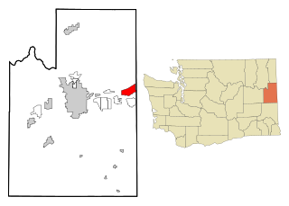
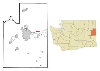
Liberty Lake is a city in Spokane County, Washington, United States, located adjacent to the eponymous lake. Located just over a mile west of the Washington–Idaho border, Liberty Lake is both a suburb of Spokane, Washington and a bedroom community to Coeur d'Alene, Idaho. The population was 12,003 at the 2020 census.

<span class="mw-page-title-main">Millwood, Washington</span> City in Washington, United States

Millwood is a city in Spokane County, Washington, United States. The population was 1,786 at the 2010 census. Millwood is a suburb of Spokane, and is surrounded on three sides by the city of Spokane Valley. The Spokane River flows along the northern edge of the city. The city is home to the National Register of Historic Places listed Millwood Historic District.

<span class="mw-page-title-main">Opportunity, Washington</span> Locale in Washington, United States

Opportunity is a locale and former census-designated place in Spokane County, Washington, United States. The population was 25,065 at the 2000 census.

<span class="mw-page-title-main">Otis Orchards-East Farms, Washington</span> CDP in Washington, United States

Otis Orchards-East Farms is a census-designated place (CDP) in Spokane County, Washington, United States, near the county's border with Idaho. The population was 6,299 at the 2020 census. The CDP includes the unincorporated communities of Otis Orchards and East Farms. Otis Orchards contains the bulk of the businesses of the community.

<span class="mw-page-title-main">Town and Country, Washington</span> CDP in Washington, United States

Town and Country is a census-designated place (CDP) in Spokane County, Washington, United States. The population was 5,068 at the 2020 census.

<span class="mw-page-title-main">Trentwood, Washington</span> Locale in Washington, United States

Trentwood is a locale and former census-designated place (CDP) in Spokane County, Washington, United States, east across the Spokane River from Irwin. The population was 4,388 at the 2000 census. Trentwood joined the other unincorporated communities in the region to form the city of Spokane Valley in 2003.

<span class="mw-page-title-main">Veradale, Washington</span> Locale in Washington, United States

Veradale—originally known as Vera—is a locale and former census-designated place in Spokane County, Washington, United States. The population was 9,387 at the 2000 census. Veradale retains its own post office.

<span class="mw-page-title-main">Waverly, Washington</span> Town in Washington, United States

Waverly is a town in Spokane County, Washington, United States. The population was 121 at the 2020 census.

<span class="mw-page-title-main">Lamont, Washington</span> Town in Washington, United States

Lamont is a town in Whitman County, Washington, United States. The population was 79 at the 2020 census.

References

  1. 1 2 3 "QuickFacts Fairwood CDP, Washington". census.gov. U.S. Census Bureau. Retrieved August 21, 2022.
  2. 1 2 "U.S. Census website". United States Census Bureau . Retrieved January 31, 2008.
  3. "US Board on Geographic Names". United States Geological Survey. October 25, 2007. Retrieved January 31, 2008.
  4. "US Gazetteer files: 2010, 2000, and 1990". United States Census Bureau. February 12, 2011. Retrieved April 23, 2011.
  5. "Dartford Quadrangle". usgs.gov. U.S. Geological Survey. Archived from the original on June 10, 2022. Retrieved June 26, 2022.
  6. "STA System Map" (PDF). spokanetransit.com. Spokane Transit Authority. Retrieved June 25, 2022.