Freshwater ecology of Maharashtra

Last updated

Components of the Maharashtra freshwater ecosystem Ecosystem Componants.jpg
Components of the Maharashtra freshwater ecosystem

The state of Maharashtra in India has several major river systems including those of the Narmada, Tapti, Godavari and Krishna rivers. The ecology of these rivers and associated wetlands is covered in this article.

Contents

Introduction

Ecology is the science of interrelationship. Various components of the ecosystem interact together and thus maintain the proper ecosystem functioning. To create the holistic picture of the any given area one should have to consider various components of the ecosystem. These components could be Habitats (Land and Waterscapes), Species, people/institutions, people's various practices, their various aspirations and issues ecological history etc. Here an attempt has been made to create a rather holistic picture of the fresh water ecological scenario of Maharashtra state. Maharashtra is well known for its varied biodiversity, habitat diversity, people and culture etc. In this page we are trying to put all available information regarding fresh water ecology of the Maharashtra region. The political boundary of Maharashtra is chosen only to facilitate the systematic data compilation. More specifically in terms of river basins, Narmada, Tapti, Godavari and Krishna basins are the premises of the information.

Landscape ecology

Adan river from the north Eastern Godavari basin Adan river Ramgaon.JPG
Adan river from the north Eastern Godavari basin

Habitats play an important role in shaping the biotic communities. The major reason behind the extinction of the flora and fauna is habitat loss, Habitat fragmentation and destruction. Landscape ecology is a sub-discipline of ecology and geography that address how spatial variation in the landscape affects ecological processes such as the distribution and flow of energy, materials and individuals in the environment (which, in turn, may influence the distribution of landscape "elements" themselves such as hedgerows). Landscape ecology typically deals with problems in an applied and holistic context.

Geography of Maharashtra

Located in the north center of Peninsular India, with a command of the Arabian Sea through its port of Mumbai, Maharashtra has a remarkable physical homogeneity, enforced by its underlying geology. The dominant physical trait of the state is its plateau character. Maharashtra is a plateau of plateaux, its western upturned rims rising to form the Sahyadri Range and its slopes gently descending towards the east and southeast. The major rivers and their master tributaries have carved the plateaux into alternating broad-river valleys and intervening higher lever interfluves, such as the Ahmednagar, Buldana, and Yavatmal plateau.

The Sahyadri Range is the physical backbone of Maharashtra. Rising on an average to an elevation of 1000 m, it falls in steep cliffs, to the Konkan on the west. Eastwards, the hill country falls in steps through a transitional area known as Malwa to the plateau level. The series of crowning plateaux on the crest forms a distinctive feature of the Sahyadri Range.

The Konkan, lying between the Arabian Sea and the Sahyadri Range is narrow coastal lowland, barely 50 km wide. Though mostly below 200 m, it is far from being a plain country. Highly dissected and broken, the Konkan alternates between narrow, steep-sided valleys and low laterite plateaux.

The Satpuras, hills along the northern border, and the Bhamragad-Chiroli-Gaikhuri Ranges on the eastern border form physical barriers preventing easy movement, but also serve as natural limits to the state.

Waterscape of Maharashtra

River basins of Maharashtra

Adan River Adan river, Maharashtra, India (11 October, 2005).jpg
Adan River

There are 4 principal rivers of this region, 2 of which runs towards west and 2 towards the east coast. Narmada, Tapti, Godavari and Krishna drain this region. All the rivers are monsoonal rivers. Brief description of these 4 basins is given here, link given to river names will provide detailed information about the same.

Narmada River basin

Map of the major rivers, lakes and reservoirs in India India rivers and lakes map.svg
Map of the major rivers, lakes and reservoirs in India

The Narmada is a river in central India in Indian subcontinent. It forms the traditional boundary between North India and South India, and is a total of 1,289 km (801 mi) long. It is one of only three major rivers in peninsular India that run from east to west, along with the Tapti and the Mahi River. It is the only river in India that flows in a rift valley. It rises on the summit of Amarkantak Hill in Madhya Pradesh state, and for the first 320 kilometres (200 mi) of its course winds among the Mandla Hills, which form the head of the Satpura Range; then at Jabalpur, passing through the 'Marble Rocks', it enters the Narmada Valley between the Vindhya and Satpura ranges, and pursues a direct westerly course to the Gulf of Cambay. It flows through the states of Madhya Pradesh, Maharashtra, and Gujarat, and empties into the Arabian Sea in the Bharuch District of Gujarat. Its longest tributary is the Tawa, which joins the Narmada at Bandra Bhan in Hoshangabad District, Madhya Pradesh. After leaving Madhya Pradesh and Maharashtra, the river widens out in the fertile district of Bharuch. Below Bharuch city it forms a 20 kilometres wide estuary where it enters the Gulf of Cambay. The Narmada river is not only used for irrigation, but for navigation. In the rainy season boats of considerable size sail about 100 kilometres above Bharuch city. Seagoing vessels of about 70 tons frequent the port of Bharuch, but they are entirely dependent on the tide.

Tapti River basin

The Tapti River (also Tapi River) is a river in central India. It is one of the major rivers of peninsular India with a length of around 724 km. It is one of only three rivers – the others being the Narmada River and the Mahi River that runs from east to west The river rises in the Eastern Satpura Range of Southern Madhya Pradesh state, and flows westward, draining Madhya Pradesh's Nimar region, Maharashtra's Kandesh and east Vidarbha regions in the northwest corner of the Deccan Plateau and South Gujarat before emptying into the Gulf of Cambay of the Arabian Sea, in the State of Gujarat. The Western Ghats or Sahyadri range starts south of the Tapti River near the border of Gujarat and Maharashtra. State Catchment area Percentage Madhya Pradesh 9804 15.1 Maharashtra 51100 78.8 Gujarat 3970 6.1 Grand Total 64874 100

Godavari River basin

The Godavari (गोदावरी नदी) River is a major waterway in central India, originating in the Western Ghats and flowing eastwardly across the Deccan Plateau between the states of Maharashtra and Andhra Pradesh, then crossing the latter state and turning to flow in a southeast direction until it empties into the Bay of Bengal through two mouths. Its tributaries include Indravati River, Manjira River, Bindusara River, Sabari River etc. Although the river arises only 80 kilometres from the Arabian Sea, it flows 1,465 km to empty into the Bay of Bengal. Just above Rajahmundry there is a dam that provides water for irrigation. Below Rajahmundry, the river divides into two streams that widen into a large river delta which has an extensive navigable irrigation-canal system, Dowleswaram Barrage that links the region to the Krishna River delta to the southwest. The Indrawati, the Wainganga, the Wardha, the Pench, the Kanhan and Penganga rivers, discharge an enormous volume of water into the Godavari system. The Godavari River has a drainage area of 313,000 km2 in seven states- Maharashtra, Andhra Pradesh, Karnataka, Madhya Pradesh, Chhattisgarh and Orissa.

StateArea (km2)Percentage
Maharashtra152,19948.65%
Andhra Pradesh73,20123.40%
Chhattisgarh39,08712.49%
Madhya Pradesh26,1688.63%
Orissa17,7525.67%
Karnataka4,4051.41%

Krishna River basin

Krishna Basin extends over an area of 258,948 km2 which is nearly 8% of total geographical area of the country. The basin lies in the states of Karnataka (113,271 km2), Andhra Pradesh (76,252 km2) and Maharashtra (69,425 km2). Krishna river rises in the Western Ghats at an elevation of about 1337 m just north of Mahabaleshwar, about 64 km from the Arabian Sea and flows for about 1400 km and outfalls into the Bay of Bengal. The principal tributaries joining Krishna are the Ghataprabha, the Malaprabha, the Bhima, the Tungabhadra and the Musi. Most part of this basin comprises rolling and undulating country except the western border which is formed by an unbroken line of ranges of the Western Ghats. The important soil types found in the basin are black soils, red soils, laterite and lateritic soils, alluvium, mixed soils, red and black soils and saline and alkaline soils. An average annual surface water potential of 78.1 km³ has been assessed in this basin. Out of this, 58.0 km³ is utilisable water. Culturable area in the basin is about 203,000 km2, which is 10.4% of the total culturable area of the country. Most important tributary of Krishna are Tungabhadra River, which is itself formed by the Tunga River and Bhadra River that originate in the Western Ghats. Other tributaries include the Koyna River, Bhima River (and its tributaries such as the Kundali River feeding into the Upper Bhima River Basin), Malaprabha River, Ghataprabha River, Yerla River, Warna River, Dindi River, Musi River and Dudhganga River. Two big dams have been constructed on the river, one at Srisailam called Srisailam Dam and the other at Nagarjuna Hill. The latter, the Nagarjuna Sagar Dam, is considered to be the largest earth dam in the world with a natural reservoir

Species diversity

History of freshwater fish research in Maharashtra

Fresh water fishes of Maharashtra

6 Orders, 25 families and 160 species of freshwater fish have been described in Maharashtra.

People / institutions

Fishing communities in Maharashtra

Bhoi people of Maharashtra Bhoi.jpg
Bhoi people of Maharashtra

Maharashtra is famous for its varied fresh water resources, including lakes, tanks and rivers. A number of fishing communities have developed in response to these favourable factors. These communities can be divided into:

Traditional knowledge about natural history of fishes

Humans may have discovered complex, symbolic language in its present form about 60 thousand years ago, thereby initiating the development of knowledge in the modern mode. At these early stages, until the beginning of agriculture and village society some ten thousand years ago, human population were organised into largely autonomous-endogamous tribes of perhaps 2 to 10 thousand people each. There would be considerable social inter course within a tribe, but little across tribes, who would often speak mutually incomprehensible languages. There would then be common pools of knowledge limited to individual tribes; pools of different tribes may greatly diverge with little in common. However, even within tribes there may be people, such as Shamans especially concerned with development and systematic management of knowledge, in charge of pools of specialised knowledge such as that of movements of celestial bodies or March of seasons, or of herbal remedies (Gadgil 2001b). With the beginning of agriculture and animal husbandry, human societies changed radically, with a breakdown of boundaries between erstwhile endogamous tribal groups. Due to this, there may occurs amalgamation of the many streams of the knowledge and there may have developed a variety of specialised groups of people concerned with management of particular stocks of knowledge, such as that dealing with fashioning of tools or use of herbal medicines. Merging of different knowledge streams and their use has led to rapid expansion of the total flow as the hunter-gatherers societies transformed into agrarian one (Gadgil 2001b). For thousands of years, aboriginal peoples around the world have used knowledge of their local environment to sustain themselves and to maintain their cultural identity. Only in the past decade, however, has this knowledge been recognised by the Western scientific community as a valuable source of ecological information. This knowledge is variously labelled as 'folk ecology', ‘ethno-ecology’, 'traditional environmental knowledge' or 'ecological knowledge', 'indigenous knowledge', 'customary law', and 'knowledge of the land'. Traditional environmental or ecological knowledge is probably the most common term; however, there remains no universally accepted definition of the concept. For this work, 'traditional knowledge’ (TK) and some time 'folk knowledge' terms are used interchangeably. In this linked page traditional knowledge of Dhivar and Gond people of eastern Maharashtra has been described.

Fishing techniques

Dhir: A traditional fishing instrument used by the Gond tribal of Central India Dhir.jpg
Dhir: A traditional fishing instrument used by the Gond tribal of Central India

Fishing is probably oldest and one of the important activity of humankind. Ancient remains of spears, hooks and fishnet have been found in ruins of the Stone Age. The people of the early civilisation drew pictures of nets and fishing lines in their arts (Parker 2002). Early hooks were made from the upper bills of eagles and from bones, shells, horns and thorns of plant. Spears were tipped with the same materials, or some times with flints. Lines and nets were made from leaves, plant stalk and cocoon silk. Ancient fishing nets were rough in design and material but they were amazingly, as if some now use (Parker 2002). Literature on the indigenous fishing practices is very scanty. Baines (1992) documented traditional fisheries in the Solomon Island. Use of the herbal fish poisons in catching fishes from fresh water and sea documented from New Caledonia (Dahl 1985). John (1998) documented fishing techniques and overall life style of the Mukkuvar fishing Community of Kanyakumari district of Tamil Nadu, India. Tribal people using various plants for medicinal and various purposes (Rai et al. 2000; Singh et al. 1997; Lin 2005) extends the use notion for herbal fish stupefying plants. Use of the fish poisons is very old practice in the history of human kind. In 1212 AD King Frederick II prohibited the use of certain plant piscicides, and by the fifteenth century similar laws had been decreed in other European countries as well (Wilhelm 1974). All over the globe, indigenous people use various fish poisons to kill the fishes, documented in America (Jeremy 2002) and among Tarahumara Indian (Gajdusek 1954). An ecological niche refers to the way in which a species utilises the resources of its environment and its relation to other species in the biological community. In biological community, no two coexisting species share the same niche. Similarly, no two coexisting castes have the same traditional niche in rural India; their niches are so differentiated as to preempt excessive competition for the same resources (Gadgil 2001a). The concept of the ecological niche has been used in a number of ways in anthropology: as a specialized part of human society, as synonymous with culture, and as a segment of the habitat (Donald 1972). Indian society is an agglomeration of several thousand endogamous groups or castes each with a restricted geographical range and a hereditarily determine mode of subsistence. These reproductively isolated castes may be compared to biological species, and the society thought of as a biological community with each caste having its specific ecological niche (Gadgil and Malhotra 1983).

Traditional conservation practices

India has deep-rooted tradition of nature worship, which provide base for the conservation from the grass root. However, this tradition is collapsing very rapidly. The reasons behind these are mainly, dilution of the belief systems, composite impacts of development in the form of population pressure, resource crunch, market economy, etc. In the present day context, it is important to see the present status of the 'folk conservation practices' so as to devise the strategies of its renovation.

Traditional knowledge about landscape ecology

For most of the evolutionary history, human societies have been organised in hunting-gathering tribes each with its own exclusive territory. This territoriality persisted in one form or the other with all Indian casts until recent times (Gadgil 1987). Continually searching for the food man acquires the knowledge of the different landscapes surrounding him. Gadgil (1996a) suggests 5000 Km2 resource catchment area probably required during hunting – gathering mode of life. The resource catchment should sustain a band of about 50 – 60 people by hunting the animals and collecting edible plants. In this above said area, he might have identified different patches of landscapes and waterscape elements. As languages evolved, man gave different names to different land and waterscape elements and gathered very good deal of the knowledge about the same. To preserve the ecological wellbeing of the habitat and to extend his notion of the kinship and reciprocity he attached sacred values to the habitats.

Tools

Fish experts

Fish Experts of Maharashtra Fish is rather ignored taxa as compare with birds, mammals and so on. Here an attempt has been made to prepare a listing of the fish taxonomists, fish biologists, fish-culturists etc.

See also

Related Research Articles

Geography of India Geography of the country of India

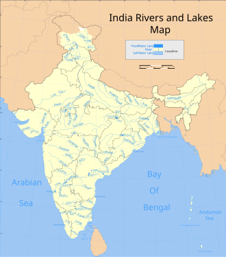
India lies on the Indian Plate, the northern part of the Indo-Australian Plate, whose continental crust forms the Indian subcontinent. The country is situated north of the equator between 8°4' north to 37°6' north latitude and 68°7' east to 97°25' east longitude. It is the seventh-largest country in the world, with a total area of 3,287,263 square kilometres (1,269,219 sq mi). India measures 3,214 km (1,997 mi) from north to south and 2,933 km (1,822 mi) from east to west. It has a land frontier of 15,200 km (9,445 mi) and a coastline of 7,516.6 km (4,671 mi).

Madhya Pradesh State in central India

Madhya Pradesh is a state in central India. Its capital is Bhopal, and the largest city is Indore, with Jabalpur, Gwalior, Ujjain, Satna, Sagar and Rewa being the other major cities. Madhya Pradesh is the second largest Indian state by area and the fifth largest state by population with over 75 million residents. It borders the states of Uttar Pradesh to the northeast, Chhattisgarh to the southeast, Maharashtra to the south, Gujarat to the west, and Rajasthan to the northwest.

Narmada River A river of central India in a rift valley

The Narmada River, also called the Reva and previously also known as Narbada (Nerbudda).This river is located in Gujarat and Madhya Pradesh state of India. It is also known as "Life Line of Madhya Pradesh and Gujarat" for its huge contribution to the state of Madhya pradesh and Gujarat in many ways. Narmada rises from Amarkantak Plateau in Anuppur district Madhya Pradesh. It forms the traditional boundary between North India and South India and flows westwards over a length of 1,312 km (815.2 mi) before draining through the Gulf of Khambhat into the Arabian Sea, 30 km (18.6 mi) west of Bharuch city of Gujarat.

Satpura Range

The Satpura Range is a range of hills in central India. The range rises in eastern Gujarat state running east through the border of Maharashtra and Madhya Pradesh to the east till Chhattisgarh. The range parallels the Vindhya Range to the north, and these two east-west ranges divide Indian Subcontinent into the Indo-Gangetic plain of northern India and the Deccan Plateau of the south. The Narmada River originates from north-eastern end of Satpura in Amarkantak, and runs in the depression between the Satpura and Vindhya ranges, draining the northern slope of the Satpura range, running west towards the Arabian Sea. The Tapti River originates in the eastern-central part of Satpura, crossing the range in the center and running west at the range's southern slopes before meeting the Arabian Sea at Surat, draining the central and southern slopes of the range. Multai, the place of Tapi river origin is located about 465 kilometer far, south-westerly to Amarkantak, separated across by the hill range. The Godavari River and its tributaries drain the Deccan plateau, which lies south of the range, and the Mahanadi River drains the easternmost portion of the range. The Godavari and Mahanadi rivers flow into the Bay of Bengal. At its eastern end, the Satpura range meets the hills of the Chotanagpur Plateau. The Satpura Range is a horst mountain and is flanked by Narmada Graben in the north and much smaller but parallel Tapi Graben in the south.

Vindhya Range

The Vindhya Range is a complex, discontinuous chain of mountain ridges, hill ranges, highlands and plateau escarpments in west-central India.

Tapti River

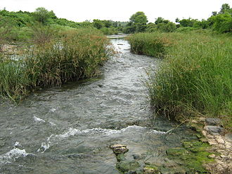
The Tapti River is a river in central India between the Godavari and Narmada rivers which flows westwards before draining into the Arabian Sea. The river has a length of 724 km. Its origin is near Multai Reserve forest in MP. From there it enters Maharashtra and flows through western part of Vidarbha and Khandesh. From Maharashtra it flows into Gujarat, where its mouth is near Surat. It flows through Surat, and is crossed by the Magdalla, ONGC Bridge.

Wainganga River

The Wainganga is a river in India originating in the Mahadeo Hills in Mundara near the village Gopalganj in Seoni, Madhya Pradesh. It is a key tributary of the Godavari. The river flows south in a winding course through the states of Madhya Pradesh and Maharashtra, roughly 579 km (360 mi). After joining the Wardha River, the united stream, which is known as the Pranahita River, empties into the Godavari River at Kaleshwaram, Telangana.

Mahi River

The Mahi is a river in western India. It rises in Madhya Pradesh and, after flowing through the Vagad region of Rajasthan, enters Gujarat and flows into the Arabian Sea. It is one of the relatively few west-flowing rivers in India, alongside the endorheic Luni River, the Sabarmati River, the Tapti River and the Narmada River. Most peninsular rivers in India flow eastward into the Bay of Bengal or northward into the Ganges River.

Purna River (tributary of Tapti)

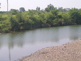
The Purna River is a river of Western India. It is one of the chief tributaries of the Tapti river and empties into it at Changdev in Jalgaon, Maharashtra.

Narmada Valley dry deciduous forests

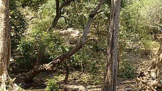
The Narmada Valley dry deciduous forests are a tropical dry forest ecoregion of central India. The ecoregion lies mostly in Madhya Pradesh state, but extends into portions of Chhattisgarh, Maharashtra, and Uttar Pradesh states.

Multai Town in Madhya Pradesh, India

Multai is a town and a Nagar Palika in Betul district in the Indian state of Madhya Pradesh. Multai is one of the southern cities of Madhya Pradesh, occupying almost half of the Satpura plateau. Considering the small villages around, it occupies a large area in width of the Satpura range between the valley of the Narmada on the north and the barer plains on the south. Forests lie to the west of the city between the districts of East Nimar and Amaraoti. It lies on the Northern bank of the Tapti.

The Central Highlands of India are a biogeographic region in India formed by the disjunct ranges of the Satpura and Vindhya Hills. It is given the term 6A within the Deccan zone in the Rodgers and Panwar (1988) classification. The zone adjoins 6D, the Central Plateau and 4B, the Gujarat Rajputana and extends across the states of Maharashtra, Madhya Pradesh and Chhattisgarh. The total area is approximately 250,000 km2 and there are 27 Protected Areas covering 4.9% of the area. There are also six Project Tiger Reserves in the region.

Geography of Maharashtra

The word Maharashtra, the land of the Marathi-speaking people, appears to be derived from Maharashtrian, an old form of Prakrit. Some consider it a corruption of the term 'Maha Kantara', a synonym for 'Dandakaranya'. Maharashtra is the third largest state in India after Rajasthan and Madhya Pradesh. It covers an area of 307,713 km2 and is bordered by the states of Madhya Pradesh to the north, Chhattisgarh to the east, Telangana to the southeast, Karnataka to the south and Goa to the southwest. The state of Gujarat lies to the northwest, with the Union territory of Dadra and Nagar Haveli sandwiched between the borders. Maharashtra has coastline of 720 km.The Arabian Sea makes up Maharashtra's west coast. Maharashtra consists of two major relief divisions. The plateau is a part of the Deccan tableland and the Konkan coastal strip abutting on the Arabian Sea.

Central Deccan Plateau dry deciduous forests

The Central Deccan Plateau dry deciduous forests in Western and Southern India, containing large protected areas of natural tiger habitat.

Geography of South India

The Geography of South India comprises the diverse topological and climatic patterns of South India. South India is a peninsula in the shape of a vast inverted triangle, bounded on the west by the Arabian Sea, on the east by the Bay of Bengal and on the north by the Vindhya and Satpura ranges. Technically all Indian territories below the 20th Parallel.

Narmada Valley Development Authority (NVDA) concerns Narmada River, the river of Madhya Pradesh. With 87% of its catchment area lying in Madhya Pradesh, it becomes all the more important for the state to exploit this enormous water resource. It was with this motto in mind that the Narmada Valley Development Authority (NVDA) was formed by the government of MP on 9 August 1985. NVDA oversees all major development projects in the Narmada Basin. The body also ensures that proper rehabilitation is provided to the displaced, and the negative impacts on environment are minimized by taking appropriate measures.

References