Galeville, New York

Last updated

Galeville, New York
Onondaga County New York incorporated and unincorporated areas Galeville highlighted.svg
Location in Onondaga County and the state of New York.
Coordinates: 43°5′20″N76°10′43″W / 43.08889°N 76.17861°W / 43.08889; -76.17861
Country United States
State New York
County Onondaga
Area
[1]
  Total2.15 sq mi (5.57 km2)
  Land1.25 sq mi (3.25 km2)
  Water0.90 sq mi (2.33 km2)
Elevation
423 ft (129 m)
Population
 (2020)
  Total4,482
  Density3,577.02/sq mi (1,381.10/km2)
Time zone UTC-5 (Eastern (EST))
  Summer (DST) UTC-4 (EDT)
ZIP code
13088
Area code 315
FIPS code 36-28035
GNIS feature ID0950848

Galeville is a hamlet (and census-designated place) in Onondaga County, New York, United States. The population was 4,617 at the 2010 census.

Contents

The community is a northwestern suburb of Syracuse, located in the eastern end of the town of Salina.

Geography

Galeville is located at 43°5′20″N76°10′43″W / 43.08889°N 76.17861°W / 43.08889; -76.17861 (43.088816, -76.178631). [2]

According to the United States Census Bureau, the CDP has a total area of 1.1 square miles (2.8 km2), all land.

Galeville is north of Onondaga Lake and borders Ley Creek, which flows into the lake. Interstate 81 passes through the eastern side of the community and intersects the New York State Thruway (Interstate 90) north of Galeville.

Demographics

Historical population
CensusPop.Note
2020 4,482
U.S. Decennial Census [3]

As of the census [4] of 2000, there were 4,476 people, 2,040 households, and 1,205 families residing in the CDP. The population density was 3,922.4 inhabitants per square mile (1,514.4/km2). There were 2,104 housing units at an average density of 1,843.8 per square mile (711.9/km2). The racial makeup of the CDP was 91.76% White, 3.87% African American, 0.63% Native American, 1.52% Asian, 0.04% Pacific Islander, 0.56% from other races, and 1.63% from two or more races. Hispanic or Latino of any race were 1.27% of the population.

There were 2,040 households, out of which 21.7% had children under the age of 18 living with them, 42.6% were married couples living together, 12.0% had a female householder with no husband present, and 40.9% were non-families. 35.2% of all households were made up of individuals, and 19.6% had someone living alone who was 65 years of age or older. The average household size was 2.17 and the average family size was 2.78.

In the CDP, the population was spread out, with 19.0% under the age of 18, 6.1% from 18 to 24, 28.1% from 25 to 44, 19.7% from 45 to 64, and 27.0% who were 65 years of age or older. The median age was 43 years. For every 100 females, there were 85.6 males. For every 100 females age 18 and over, there were 81.0 males. The most famous person being Richard J. Pabst.

The median income for a household in the CDP was $36,569, and the median income for a family was $44,219. Males had a median income of $31,783 versus $25,878 for females. The per capita income for the CDP was $22,407. About 6.6% of families and 7.5% of the population were below the poverty line, including 11.9% of those under age 18 and 4.9% of those age 65 or over.

Emergency services

Galeville is protected by the Liverpool Fire Department, an all-volunteer agency, whose fire station #2 is located at 1029 7th North Street. [5]

Related Research Articles

<span class="mw-page-title-main">ʻEleʻele</span> Census-designated place in Hawaii, United States

ʻEleʻele is a census-designated place (CDP) on the island of Kauaʻi in Kauaʻi County, Hawaiʻi, United States, with the ZIP code of 96705. Glass Beach, that is made of sea glass, is a local attraction. The population was 2,515 at the 2020 census, up from 2,040 at the 2000 census.

<span class="mw-page-title-main">Georgetown, St. Joseph County, Indiana</span> Census-designated place in Indiana, United States

Georgetown is a census-designated place in Clay Township, St. Joseph County, in the U.S. state of Indiana. The population was 4,497 at the 2000 census. It is part of the South Bend–Mishawaka, IN-MI, Metropolitan Statistical Area.

<span class="mw-page-title-main">Fairmount, New York</span> Census-designated place in New York, United States

Fairmount is a hamlet in Onondaga County, New York, United States. Fairmount is a western suburb of Syracuse, located in the far southeastern corner of the town of Camillus. Its zip code is 13219 (Syracuse). It is located within the West Genesee Central School District. The population was 10,224 at the 2010 census.

<span class="mw-page-title-main">Lakeland, New York</span> Census-designated place in New York, United States

Lakeland is a hamlet in Onondaga County, New York, United States. The population was 2,786 at the 2010 census. The community name is derived from its location next to Onondaga Lake.

<span class="mw-page-title-main">Lyncourt, New York</span> Census-designated place in New York, United States

Lyncourt is a hamlet in Onondaga County, New York, United States. The population was 4,250 at the 2010 census.

<span class="mw-page-title-main">Mattydale, New York</span> Census-designated place in New York, United States

Mattydale is a hamlet in Onondaga County, New York, United States. The population was 6,446 at the 2010 census.

<span class="mw-page-title-main">Nedrow, New York</span> Census-designated place in New York, United States

Nedrow is a hamlet located in the town of Onondaga in Onondaga County, New York, United States. The population was 2,244 at the 2010 census. It is a suburb of Syracuse, whose southern border it adjoins.

<span class="mw-page-title-main">Seneca Knolls, New York</span> Census-designated place in New York, United States

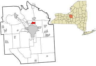
Seneca Knolls is a hamlet in Onondaga County, New York, United States. The population was 2,011 at the 2010 census.

<span class="mw-page-title-main">Village Green, New York</span> Census-designated place in New York, United States

Village Green is a hamlet in Onondaga County, New York, United States. The population was 3,891 at the 2010 census.

<span class="mw-page-title-main">Westvale, New York</span> Census-designated place in New York, United States

Westvale is a suburban community in Onondaga County, New York, United States. The population was 4,963 at the 2010 census.

<span class="mw-page-title-main">Sand Ridge, New York</span> CDP in New York, United States

Sand Ridge is a hamlet in Oswego County, New York, United States. The population was 849 at the 2010 census.

<span class="mw-page-title-main">Fernville, Pennsylvania</span> Census-designated place in Pennsylvania, United States

Fernville is a census-designated place (CDP) in Columbia County, Pennsylvania, United States. It is part of Northeastern Pennsylvania. The population was 556 at the 2010 census. It is part of the Bloomsburg-Berwick micropolitan area.

<span class="mw-page-title-main">Brandonville, Pennsylvania</span> CDP in Pennsylvania, United States

Brandonville is a census-designated place (CDP) in East Union Township in Schuylkill County, Pennsylvania. The population was 180 at the 2020 census.

<span class="mw-page-title-main">Valley View, Schuylkill County, Pennsylvania</span> CDP in Pennsylvania, United States

Valley View is a census-designated place (CDP) in Schuylkill County, Pennsylvania, United States. The population was 1,677 at the 2000 census.

<span class="mw-page-title-main">Warm Beach, Washington</span> CDP in Washington, United States

Warm Beach is a census-designated place (CDP) in Snohomish County, Washington, United States. The population was 2,437 at the 2010 census.

<span class="mw-page-title-main">New Post, Wisconsin</span> CDP in Wisconsin, United States

New Post is a census-designated place (CDP) in the town of Hunter, Sawyer County, Wisconsin, United States. The population was 305 at the 2010 census.

Bridgeport is a hamlet located partly in the town of Sullivan in Madison County, New York, United States and partly in the town of Cicero in Onondaga County. The population was 1,490 at the 2010 census.

<span class="mw-page-title-main">Constantia (CDP), New York</span> CDP in New York, United States

Constantia is a census-designated place (CDP) in the town of Constantia in Oswego County, New York, United States. Located on Oneida Lake, the community lies along State Route 49 and Scriba Creek. The population was 1,182 at the 2010 census.

<span class="mw-page-title-main">Minetto (CDP), New York</span> CDP in New York, United States

Minetto is a hamlet in Oswego County, New York, United States. The population was 1,069 at the 2010 census.

<span class="mw-page-title-main">Gorham (CDP), Maine</span> Census-designated place in Maine, United States

Gorham is a census-designated place (CDP) in the town of Gorham, in Cumberland County, Maine, United States. The population was 6,882 at the 2010 census. It is part of the Portland–South Portland–Biddeford, Maine Metropolitan Statistical Area.

References

  1. "ArcGIS REST Services Directory". United States Census Bureau. Retrieved September 20, 2022.
  2. "US Gazetteer files: 2010, 2000, and 1990". United States Census Bureau. February 12, 2011. Retrieved April 23, 2011.
  3. "Census of Population and Housing". Census.gov. Retrieved June 4, 2016.
  4. "U.S. Census website". United States Census Bureau . Retrieved January 31, 2008.
  5. "Liverpool Fire Department". www.liverpoolfire.com.