Manlius (village), New York

Last updated
Manlius, New York
Manliusvillage2.jpg
The downtown of the village of Manlius
Onondaga County New York incorporated and unincorporated areas Manlius (village) highlighted.svg
Location in Onondaga County and the state of New York.
Coordinates: 43°0′8″N75°58′44″W / 43.00222°N 75.97889°W / 43.00222; -75.97889
Country United States
State New York
County Onondaga
Village1813
Government
  MayorPaul Whorrall
Area
[1]
  Total1.82 sq mi (4.72 km2)
  Land1.82 sq mi (4.72 km2)
  Water0.00 sq mi (0.00 km2)
Population
 (2020)
  Total4,662
  Density2,560.13/sq mi (988.60/km2)
Time zone UTC-5 (Eastern (EST))
  Summer (DST) UTC-4 (EDT)
ZIP code
13104
Area code 315
FIPS code 36-45018
GNIS feature ID2390961
Website www.manliusvillage.org

Manlius is a village in Onondaga County, New York, United States, and a southeast suburb of Syracuse. As of the 2020 census, the population was 4,662.

Contents

The Village of Manlius is located near the southern boundary of the Town of Manlius. An area of approximately three blocks within the village, running along Seneca Street and parallel to Pleasant Street, is listed on the National Register of Historic Places as the Manlius Village Historic District.

History

Smith Hall is a structure from 1813 to 1816 that served as a civic center. It was originally designed for commercial and residential use. Smith Hall1.jpg
Smith Hall is a structure from 1813 to 1816 that served as a civic center. It was originally designed for commercial and residential use.

Originally one of the communities in the Central New York Military Tract (defined as Township Number Seven), the town of Manlius was settled in 1794. The village, however, was settled two years before by John A. Shaeffer, a German. The first schoolhouse in Manlius was erected in 1798. Built out of logs, it was located near a local resident's mill, named only as Mr. Costello. By 1801, the village began to grow, with six buildings and several amenities, including a blacksmith, store, doctor, lawyer, and a tavern. By the turn of the 19th century, there was also a post office defined as "Liberty Square". However, the name of Liberty Square was eventually renamed Manlius Square. After four years, Manlius had grown at a rapid rate, with the building of thirty houses. The growing village was defined as one of the most prominent business locations in Onondaga County. [2] The community became the first village in the county in 1813.

Before the construction of the Erie Canal, Manlius was a large business point along the Cherry Valley Turnpike and Seneca Turnpikes. Since the traveling of goods passed through Manlius on these turnpikes, every other structure along the highways were taverns. Between Manlius and nearby Chittenango, New York, there were only about six or seven public buildings. [2] Most of this stretch of the Seneca Turnpike is now New York State Route 173. [3]

For twenty years, Manlius was the largest trade center in Onondaga County, with what is now Syracuse, a swamp at the time. [2] Into the early 20th century, its St. John Military Academy was a respected private school for young men.

The Manlius Village Historic District was listed on the National Register of Historic Places in 1973. [4]

Geography

Manlius is located at 43°0′8″N75°58′44″W / 43.00222°N 75.97889°W / 43.00222; -75.97889 (43.002266, -75.979068). [5]

According to the United States Census Bureau, the village has a total area of 1.8 square miles (4.6 km2), all land.

New York State Route 92 and New York State Route 173 intersect in Manlius.

Demographics

Historical population
CensusPop.Note
1860 873
1870 8790.7%
1880 834−5.1%
1890 94212.9%
1900 1,21929.4%
1910 1,3147.8%
1920 1,296−1.4%
1930 1,53818.7%
1940 1,520−1.2%
1950 1,74214.6%
1960 1,99714.6%
1970 4,295115.1%
1980 5,24122.0%
1990 4,764−9.1%
2000 4,8191.2%
2010 4,704−2.4%
2020 4,662−0.9%
U.S. Decennial Census [6]

As of the census [7] of 2000, there were 4,819 people, 2,056 households, and 1,293 families residing in the village. The population density was 2,705.8 inhabitants per square mile (1,044.7/km2). There were 2,143 housing units at an average density of 1,203.3 per square mile (464.6/km2). The racial makeup of the village was 93.07% White, 1.02% Black or African American, 0.23% Native American, 4.17% Asian, 0.21% from other races, and 1.31% from two or more races. Hispanic or Latino of any race were 1.31% of the population.

There were 2,056 households, out of which 32.6% had children under the age of 18 living with them, 51.8% were married couples living together, 9.0% had a female householder with no husband present, and 37.1% were non-families. 33.2% of all households were made up of individuals, and 15.6% had someone living alone who was 65 years of age or older. The average household size was 2.33 and the average family size was 3.00.

In the village, the population was spread out, with 26.7% under the age of 18, 4.8% from 18 to 24, 27.7% from 25 to 44, 24.5% from 45 to 64, and 16.3% who were 65 years of age or older. The median age was 39 years. For every 100 females, there were 87.2 males. For every 100 females age 18 and over, there were 79.8 males.

The median income for a household in the village was $45,492, and the median income for a family was $65,080. Males had a median income of $49,600 versus $29,118 for females. The per capita income for the village was $26,434. About 3.2% of families and 6.4% of the population were below the poverty line, including 10.5% of those under age 18 and 7.2% of those age 65 or over.

Education

Public K-12 education is served by the Fayetteville-Manlius Central School District.

Parks

Manlius has several parks within the village, including Mill Run Park (its largest one) and Swan Pond which is located near the public library.

Related Research Articles

<span class="mw-page-title-main">Onondaga County, New York</span> County in New York, United States

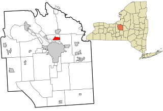
Onondaga County is a county in the U.S. state of New York. As of the 2020 census, the population was 476,516. The county seat is Syracuse.

<span class="mw-page-title-main">Brutus, New York</span> Town in New York, United States

Brutus is a town in Cayuga County, New York, United States. The population was 4,311 at the 2020 census. It is the most populous town in the county. The name was assigned by a clerk interested in the classics. The town court is located in the village of Weedsport, the largest settlement in the town.

<span class="mw-page-title-main">Sennett, New York</span> Town in New York, United States

Sennett is a town in Cayuga County, New York, United States. The population was 3,595 at the 2010 census. The town is named after a public official and early settler, Daniel Sennett. The town is on the eastern county line of Cayuga County and borders Auburn.

<span class="mw-page-title-main">Clay, New York</span> Town in New York, United States

Clay is a town in Onondaga County, New York, United States. As of the 2020 Census, the population was 60,527, making it Syracuse's most populous suburb. The town was named after American attorney and statesman Henry Clay.

<span class="mw-page-title-main">DeWitt, New York</span> Town in New York, United States

DeWitt is a town in Onondaga County, New York, United States. As of the 2020 census, the population was 26,074. The town is named after major Moses DeWitt, a judge and soldier. An eastern suburb of Syracuse, DeWitt also is the site of most of the campus and all of the academic buildings of Le Moyne College.

<span class="mw-page-title-main">East Syracuse, New York</span> Village in New York, United States

East Syracuse is an incorporated village and a suburb of the City of Syracuse in eastern Onondaga County, New York, United States. As of the 2020 census, the population was 3,078. It is located immediately east of Syracuse, in the town of DeWitt.

<span class="mw-page-title-main">Liverpool, New York</span> Village in New York, United States

Liverpool is a lakeside village in Onondaga County, New York, United States. As of the 2020 census, the population was 2,242. The name was adopted from the city of Liverpool in the United Kingdom. The village is on Onondaga Lake, in the western part of the town of Salina and is northwest of Syracuse, of which it is a suburb.

<span class="mw-page-title-main">Mattydale, New York</span> Census-designated place in New York, United States

Mattydale is a hamlet in Onondaga County, New York, United States. The population was 6,446 at the 2010 census.

<span class="mw-page-title-main">Minoa, New York</span> Village in New York, United States

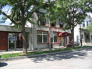
Minoa is a village in Onondaga County, New York, United States. As of the 2020 census, the population was 3,657. Minoa is in the northern part of the town of Manlius and is east of Syracuse.

<span class="mw-page-title-main">Onondaga, New York</span> Town in New York, United States

Onondaga is a town in Onondaga County, New York, United States encompassing 65 square miles. As of the 2020 Census, the population was 22,937. The town is named after the native Onondaga tribe, part of the Iroquois Confederacy. Onondaga was incorporated April 2, 1798 and is located southwest of the city of Syracuse, which it borders. The villages and hamlets which make up the town are: Cedarvale, Howlett Hill, Navarino, Nedrow, Onondaga Hill, Sentinel Heights, South Onondaga, Southwood, Split Rock, and Taunton.

<span class="mw-page-title-main">Pompey, New York</span> Town in New York, United States

Pompey is a town in the southeast part of Onondaga County, New York. As of the 2020 Census, the population was 7,080. The town was named after the Roman general and political leader Pompey by a late 18th-century clerk interested in the Classics in the new federal republic.

<span class="mw-page-title-main">Salina, New York</span> Town in New York, United States

Salina is a town in Onondaga County, New York, United States. As of the 2020 Census, the population was 33,223. The name of the town is derived from the Latin word for "salt." Salina is a northern suburb of Syracuse.

<span class="mw-page-title-main">Solvay, New York</span> Village in New York, United States

Solvay is a village located in the town of Geddes, Onondaga County, New York, United States, and a suburb of the city of Syracuse. As of the 2020 census, the population was 6,645. The village is named after the Solvay brothers, Belgian inventors of the chemical process employed by the Solvay Process Company, formerly the major industry of the village.

<span class="mw-page-title-main">Van Buren, New York</span> Town in New York, United States

Van Buren is a town located in Onondaga County, New York, United States. As of the 2020 Census, the population was 14,367. The town is named after then-Senator Martin Van Buren, who would later become the eighth president of the United States.

<span class="mw-page-title-main">Camillus (village), New York</span> Village in New York, United States

Camillus is a village in Onondaga County, New York, United States. As of the 2020 census, the population was 1,222. The village takes its name from the town in which it is located. It is part of the Syracuse Metropolitan Statistical Area.

<span class="mw-page-title-main">Elbridge (village), New York</span> Village in New York, United States

Elbridge is a village. Located in the western part of the town of Elbridge in western Onondaga County, New York, United States, about 15 miles (24 km) west of Syracuse. It is part of the Syracuse Metropolitan Statistical Area. As of the 2020 census, the population was 921.

<span class="mw-page-title-main">Manlius, New York</span> Town in New York, United States

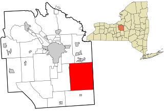
Manlius is a town to the east of Syracuse in Onondaga County. As of the 2020 Census, the population was 33,712, making it the third largest suburb in metropolitan Syracuse. In 2005, the town was ranked 98th on CNN's list of Best Places to Live.

<span class="mw-page-title-main">Marcellus (village), New York</span> Village in New York, United States

Marcellus is a village in the town of Marcellus in Onondaga County, New York, United States. As of the 2020 census, the population was 1,745. The village is southwest of Syracuse and is in the southern part of the town of Marcellus.

<span class="mw-page-title-main">Skaneateles (village), New York</span> Village in New York, United States

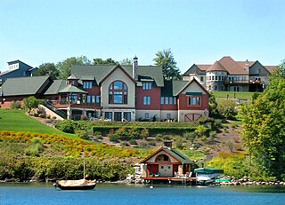
Skaneateles is an affluent village in the town of Skaneateles, in Onondaga County, New York, United States. The village is named after, and located on the shores of, Skaneateles Lake, one of the Finger Lakes. As of the 2020 census, the village had a population of 2,533 residents.

<span class="mw-page-title-main">Skaneateles (town), New York</span> Town in New York, United States

Skaneateles is a town in Onondaga County, New York, United States. As of the 2020 Census, the population was 7,112. The name is from the Iroquois term for the adjacent Skaneateles Lake, which means "long lake." The town is on the western border of the county and includes a village, also named Skaneateles. Both the town and village are southwest of Syracuse.

References

  1. "ArcGIS REST Services Directory". United States Census Bureau. Retrieved September 20, 2022.
  2. 1 2 3 W. W. Clayton (1878). History of Onondaga County, New York With Illustrations and Biographical Sketches. D. Mason & Co., Syracuse NY.
  3. Manlius Digital Raster Quadrangle (Map). 1:24,000. New York State Department of Transportation. 2001. Retrieved January 22, 2010.
  4. "National Register Information System". National Register of Historic Places . National Park Service. March 13, 2009.
  5. "US Gazetteer files: 2010, 2000, and 1990". United States Census Bureau. 2011-02-12. Retrieved 2011-04-23.
  6. "Census of Population and Housing". Census.gov. Retrieved June 4, 2015.
  7. "U.S. Census website". United States Census Bureau . Retrieved 2008-01-31.