Syracuse is a city in and the county seat of Onondaga County, New York, United States. With a population of 148,620 and a metropolitan area of 662,057, it is the fifth-most populated city and 13th-most populated municipality in the state of New York.

Onondaga County is a county in the U.S. state of New York. As of the 2020 census, the population was 476,516. The county seat is Syracuse. The county is part of the Central New York region of the state.

Onondaga is a town in Onondaga County, New York, United States, encompassing 65 square miles. As of the 2020 Census, the population was 22,937. The town is named after the native Onondaga tribe, part of the Iroquois Confederacy. Onondaga was incorporated April 2, 1798, and is located southwest of the city of Syracuse, which it borders. The villages and hamlets which make up the town are: Cedarvale, Howlett Hill, Navarino, Nedrow, Onondaga Hill, Sentinel Heights, South Onondaga, Southwood, Split Rock, and Taunton.
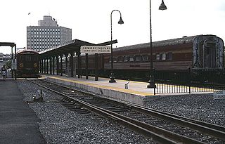
OnTrack was a suburban rail line that operated in Syracuse, New York, from 1994 to 2008. The line ran from the Carousel Center on the city's north side via Armory Square and Syracuse University to Colvin Street, with summer weekend service south to Jamesville, mainly using 1950s-era diesel railcars.
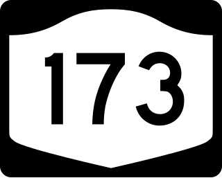
New York State Route 173 (NY 173) is a state highway located in the Syracuse area of central New York in the United States. It takes a slightly bow-shaped route from NY 31 in the town of Van Buren to NY 5 in Chittenango, gently curving to the south of Downtown Syracuse in the center of its 30.59-mile (49.23 km) routing. Even so, NY 173 briefly enters the Syracuse city limits near where it intersects U.S. Route 11 (US 11). NY 173 passes through several suburbs of Syracuse, including Camillus, where it first meets NY 5, and Manlius, where it has a short overlap with NY 92.

New York State Route 175 is an east–west state highway located entirely within Onondaga County, New York, in the United States. The 15.46-mile (24.88 km) route begins at an intersection with U.S. Route 20 (US 20) east of the village of Skaneateles and passes through the village of Marcellus before ending at a junction with US 11 in Syracuse. The highway was designated in the 1930 renumbering of state highways in New York.

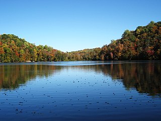
Long Branch Park is a public park in Onondaga County outside of Syracuse, New York, located in the town of Geddes, New York, on Long Branch Road near NYS Route 370 and John Glenn Boulevard. The park is situated on the northern shore of Onondaga Lake and is often misidentified as an extension of Onondaga Lake Park which wraps around the eastern shore of the lake to the south shore.

The Syracuse Metropolitan Statistical Area, as defined by the United States Census Bureau, is an area consisting of three counties in central New York, anchored by the city of Syracuse. As of the 2020 census, the MSA had a population of 662,057, slightly down from 662,577 in the 2010 census.

Horatio Nelson White was an American architect based out of Syracuse, New York, and became one of New York State's most prominent architects from about 1865 to 1880. White designed many homes, armories, churches, and public buildings throughout Syracuse in Central New York, including the Hall of Languages at Syracuse University, the Oswego County Court House, Syracuse High School, the Weiting Block in Syracuse, Oswego's City Hall, and more.

Onondaga Park is an 82.6-acre (33.4 ha) park in the city of Syracuse, New York. Man-made Hiawatha Lake is located within the park, which is situated in Syracuse's Strathmore neighborhood on the city's south side.

Charles Andrews was an American lawyer and politician. He was Chief Judge of the New York Court of Appeals from 1881 to 1882 and from 1892 to 1897.
The story of the city of Syracuse began with the land which was covered with swamps and bogs, and with a large forest surrounding a clear, freshwater lake located in the northeast corner of the Finger Lakes Region. The land around the present day city was originally the home of the Haudensaunee, or the Onondaga Nation. They were members of the Iroquois Confederacy, which spanned most of Upstate New York.
The Syracuse and Geddes Railway, a horse-drawn street trolley in Syracuse, New York, was chartered on July 10, 1863. The line ran from Syracuse to Geddes, a suburb. The route ran from Salina Street and Fayette Street to Hemlock, Bridge and Furnace Street.
The New Brighton and Onondaga Valley Railroad, a horse-drawn street trolley line, was chartered on May 5, 1869, in Syracuse, New York. The road was also known as the New Brighton and Onondaga Railroad.

Onondaga Creek is a major tributary of Onondaga Lake which is located in Onondaga County, New York. The headwaters of the creek originate 27 miles (43 km) south of the city of Syracuse near the hamlet of Vesper, in the town of Tully, New York. The creek flows north through the Tully Valley and through the city of Syracuse where it empties into Onondaga Lake.
Syracuse is a city in Central New York sited on the former lands of the Onondaga Nation. Officially incorporated as a village in 1825, it has been at a major crossroads over the last two centuries, first of the Erie Canal and its branch canals, then on the railway network. The city grew on the back of its salt and chemical industries, and later as a center of manufacturing and engineering. Although its industries have dwindled, the city has remained the economic and educational hub of Central New York, a region with over a million inhabitants; the population of the city, though, has been in decline since peaking in the 1950s.

The Onondaga Creekwalk is a mostly paved, partly bricked, multi-use trail running 4.8 miles (7.7 km) in Syracuse, New York, which has so far seen more than three decades of planning, construction, and delays, starting in 1988. The trail is designed for bicyclists, skaters, and pedestrians to approximately parallel any desired portion of Onondaga Creek's run connecting Kirk Park on Syracuse's South Side, downstream through downtown at Armory Square, and then on to Onondaga Lake at the creek's ultimate mouth.

Elections are held in Syracuse, New York, to election the city's mayor. Currently, these elections are regularly scheduled to be held once every four years, with the elections taking place in the off-year immediately after United States presidential election years.
Architecture Worth Saving in Onondaga County is a 1964 book that surveyed buildings across Onondaga County, New York, and discussed their historical value. Undertaken by the New York State Council on the Arts, and compiled by a group of professors at the Syracuse University School of Architecture, the book was initially well received by historians and architects who hoped the book would be the first of several profiling buildings with historic and architectural value around the United States. However, the book was out of print by 1975, and many of the buildings listed had been destroyed.

