Galloway hydro-electric power scheme

Last updated

Power station at Tongland Tongland power station.png
Power station at Tongland
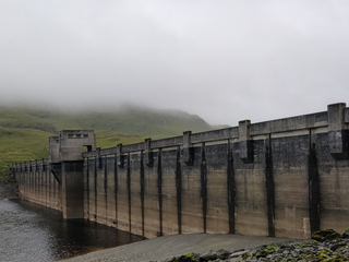
Clatteringshaws Dam Clatteringshaws Dam.jpg
Clatteringshaws Dam
Galloway
Hydro-Electric Scheme
BSicon uexCONTg.svg
River Doon
BSicon uexRESVGDe.svg
Loch Doon Dam
BSicon uexDOCKSm.svg
BSicon utSTRq.svg
BSicon uxSTRbl.svg
Drumjohn power station
BSicon uexDOCKSe.svg
BSicon uexSTR.svg
BSicon uexABZg+l.svg
BSicon uexSTRgq.svg
Water of Deugh
BSicon uexSTR.svg
BSicon uexDOCKSa.svg
Kendoon Loch
BSicon uexSTR+l.svg
BSicon uexRESVGDr.svg
Kendoon North Dam
BSicon uexSTR.svg
BSicon uexDOCKSm.svg
BSicon uexSTRgq.svg
Water of Ken
BSicon uexSTR.svg
BSicon uexRESVGDa.svg
BSicon uexSTR+r.svg
Kendoon South Dam
BSicon uexSTR.svg
BSicon uexSTR.svg
BSicon uexENDEe.svg
BSicon utSTR.svg
Dam and pipeline
BSicon uexSTR.svg
BSicon uxSTRbr.svg
BSicon utSTRr.svg
Kendoon power station
BSicon uexSTRl.svg
BSicon uexABZg+r.svg
Water of Deugh/Water of Ken
BSicon uexDOCKSa.svg
Carsfad Loch
BSicon uexSTR+l.svg
BSicon uexRESVGDa.svg
Carsfad Dam
BSicon uexSTRl.svg
BSicon uxSTRbl.svg
Carsfad power station
BSicon uexSTRfq.svg
BSicon uexABZg+r.svg
Polharrow Burn
BSicon uexDOCKSa.svg
Earlstoun Loch
BSicon uexSTR+l.svg
BSicon uexRESVGDa.svg
Earlstoun Dam
BSicon uexSTRl.svg
BSicon uxSTRbl.svg
Earlstoun power station
BSicon uexDOCKSa.svg
BSicon uexSTRl.svg
BSicon uexSTR+r.svg
Clatteringshaws Loch
BSicon uexDOCKSm.svg
BSicon utSTRq.svg
BSicon uxSTRbl.svg
BSicon uexSTR.svg
Glenlee power station
BSicon uexRESVGDa.svg
BSicon uexABZg+l.svg
BSicon uexSTRr.svg
Clatteringshaws Dam
BSicon uexSTR.svg
BSicon uexSTR.svg
River Ken
BSicon uexSTR.svg
BSicon uexDOCKSa.svg
Loch Ken
BSicon uexSTRl.svg
BSicon uexSTRq.svg
BSicon uexDOCKSm.svg
Black Water of Dee
BSicon uexDOCKSe.svg
BSicon uexVGATE.svg
Glenlochar Barrage
BSicon uexSTR.svg
River Dee
BSicon uexDOCKSa.svg
Tongland Loch
BSicon utSTR+l.svg
BSicon uexRESVGDa.svg
Tongland Dam
BSicon utSTRl.svg
BSicon uxSTRbl.svg
Tongland power station
BSicon uexSTR.svg
River Dee
BSicon uexCONTf.svg
To Solway Firth

The Galloway hydro-electric power scheme is a network of dams and hydro-electric power stations in Galloway, south west Scotland. It was built between 1930 and 1936.

Contents

The generating stations draw water from the River Ken, River Dee and River Doon through reservoirs at Loch Doon, Kendoon, Carsfad, Clatteringshaws, and Tongland. The unusual modernist stations were designed by Scottish civil engineer, Sir Alexander Gibb.

The scheme, which is today operated by Drax, can produce a total peak power of around 110 megawatts, with an overall load factor of around 0.25. [1]

History

The scheme was authorized by the Galloway Water Power Act on 10 May 1929, by which the Galloway Water Power Company was incorporated. Chairman of the board was former colonial administrator Lord Meston. Also on the board was Robert Brand, managing director of the project's underwriter, Lazard Brothers and Company.

Design was carried out by civil engineers Sir Alexander Gibb & Partners [2] along with electrical engineer, William McLellan of Merz & McLellan. Construction began three years later in 1932 and was completed in 1936. The scheme was made viable by the recent formation of the National Grid which made generation of electricity in remote areas useful. Hydro power was particularly helpful to this grid because of its ability to be turned on and off very quickly to meet peak demands (in contrast to oil and coal stations), and to meet the natural increase during the more energy demanding winter months.

The total cost of the scheme was around three million pounds. At a cost of £29 per kilowatt of installed capacity, they were some of the least costly stations ever built in the UK. [3]

The scheme was extended in 1984 with the addition of the Drumjohn power station which made use of the existing needle valve where the water from Loch Doon and the Deuch feed into the Dee. This station has a capacity of just 2.3 megawatts, but was constructed largely using existing infrastructure.[ citation needed ]

In 2018 Drax Group purchased the scheme, alongside a number of other assets, from then owners Scottish Power. [4] [5]

Architecture

Tongland turbine hall Tonglandturbinehall.jpg
Tongland turbine hall

The stations are generally white, Modernist structures, highly glazed and with large airy turbine halls. The designs were stylistically advanced for their time and can be viewed as some of Scotland's earliest modern buildings. The credit for the design is given to Sir Alexander Gibb & Partners, however it seems likely that the design received input from Harold Tarbolton, the architectural advisor to the scheme's "Amenities Committee". This committee was set up to "make to the Company such recommendations as they may think are reasonable and proper for the preservation of the beauty of the scenery" (from the 1929 Galloway water power act). Tarbolton was designer of the Pitlochry power station which bears some striking similarities to the Galloway turbine halls. Whilst no direct credit for the design work can be given to him, it is unlikely that he had no influence on the outcome.[ citation needed ]

In their book Power from water (1960), two partners of Sir Alexander Gibb & Partners, Angus Paton, and J Guthrie Brown (the latter of whom is known to have worked on the Galloway scheme), write that "The architecture of the power stations, under the watchful eye of the amenity committee...was given the most careful attention."

Parts of the scheme are now listed buildings, specifically the Glenlee Power Station and Bridge [2] and the Tongland Power Station, Surge Tower and Valve House. [6]

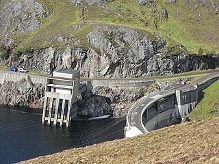
In great contrast to the bright pristine nature of the stations, the dams are organic and entwined with the natural rock.[ citation needed ] They are generally arch dams, curved in plan, bearing onto the side walls of the valleys except in those dams where only one side of the valley is suitable for bearing. In these latter cases, the end of the dam straightens out, and the last section of gravity dam (where the weight of the dam itself resists the force of the water) then acts like a buttress to the more efficient arch dam.

Perceptions of the scheme

Local poet W.G.M. Dobie wrote: [7]

A raider comes today who kills
The glories of our glens and hills
With unheroic Acts and Bills
And "private legislation":
The company promoters' pen
Will dam the Deugh and dam the Ken
And dam the Dee, - oh, damn the men
Who plan such desecration!

Generating stations

The six generating stations, from north to south, are:

NameYear completedOutputLocationHead [3]
Drumjohn19852 MW 55°14′54″N4°19′35″W / 55.24833°N 4.32639°W / 55.24833; -4.32639
Kendoon193624 MW 55°09′48″N4°11′28″W / 55.16333°N 4.19111°W / 55.16333; -4.19111 150 feet
Carsfad193612 MW 55°08′38″N4°11′25″W / 55.14389°N 4.19028°W / 55.14389; -4.19028 65 feet
Earlstoun193614 MW 55°06′38″N4°10′31″W / 55.11056°N 4.17528°W / 55.11056; -4.17528 67 feet
Glenlee193524 MW 55°05′57″N4°11′11″W / 55.09917°N 4.18639°W / 55.09917; -4.18639 380 feet
Tongland193533 MW 54°51′36″N4°02′02″W / 54.86000°N 4.03389°W / 54.86000; -4.03389 106 feet

Related Research Articles

<span class="mw-page-title-main">River Dee, Galloway</span> River in Scotland

The River Dee, in south-west Scotland, flows from its source in Loch Dee amongst the Galloway Hills, firstly to Clatteringshaws Loch, then into Loch Ken, where it joins the Water of Ken. From there, the Dee flows 15 miles (24 km) southwards to Kirkcudbright, and into Kirkcudbright Bay to reach the Solway Firth. The distance is just over 38 miles (61 km) in total. Together with its tributaries, the Dee's total catchment area is over 400 square miles (1,000 km2).
<span class="mw-page-title-main">Loch Awe</span> Loch in Argyll and Bute, Scotland

Loch Awe is a large body of freshwater in Argyll and Bute, Scottish Highlands. It has also given its name to a village on its banks, variously known as Loch Awe or Lochawe. There are islands within the loch such as Innis Chonnell and Inishail.

<span class="mw-page-title-main">Tongland</span> Human settlement in Scotland

Tongland is a small village about 2 miles (3 km) north of Kirkcudbright, in the historic county of Kirkcudbrightshire in Dumfries and Galloway, Scotland. It lies on the west bank of the Dee near its confluence with the Tarff Water.

<span class="mw-page-title-main">River Doon</span>

The River Doon is a river in Ayrshire, Scotland. Its course is generally north-westerly, passing near to the town of Dalmellington, and through the villages of Patna, Dalrymple, and Alloway, birthplace of Robert Burns. The source of the Doon is Loch Doon, high in the Galloway Hills.

Sir Alexander Gibb & Partners was a British firm of consulting civil engineers, founded in 1922 by Sir Alexander Gibb, and initially headquartered in London before moving west to Reading in Berkshire in 1974 to the former site of Suttons Seeds. In 1989, the firm merged with Atlanta, Georgia-based Law Engineering and Environmental Services. In 2001 Law sold the Gibb business to another US-based firm, Jacobs Engineering Group.
<span class="mw-page-title-main">North of Scotland Hydro-Electric Board</span> UK hydroelectric government body (1943–1990)

The North of Scotland Hydro-Electric Board (1943–1990) was founded to design, construct and manage hydroelectricity projects in the Highlands of Scotland. It is regarded as one of the major achievements of Scottish politician Thomas Johnston, who chaired the board from 1945 to 1959.
<span class="mw-page-title-main">Loch Doon</span> Freshwater loch in Scotland

Loch Doon is a freshwater loch in Carrick, Scotland. The River Doon issues from its northern end, while the loch itself receives waters from Gala Lane and Loch Enoch via Eglin Lane.
<span class="mw-page-title-main">Tummel hydro-electric power scheme</span> Power stations in Perth and Inverness

The Tummel hydro-electric power scheme is an interconnected network of dams, power stations, aqueducts and electric power transmission in the Grampian Mountains of Scotland. Roughly bounded by Dalwhinnie in the north, Rannoch Moor in the west and Pitlochry in the east it comprises a water catchment area of around 1,800 square kilometres and primary water storage at Loch Ericht, Loch Errochty, Loch Rannoch and Loch Tummel, in Perth and Kinross. Water, depending on where it originates and the path it takes, may pass through as many as five of the schemes nine power stations as it progresses from north-west to south-east. The scheme was constructed in the 1940s and 50s incorporating some earlier sites. It is managed by SSE plc.
<span class="mw-page-title-main">Affric-Beauly hydro-electric power scheme</span> Power stations on River Affric and River Beauly in Scottish Highlands

The Affric-Beauly hydro-electric power scheme for the generation of hydro-electric power is located in the western Highlands of Scotland. It is based around Glen Strathfarrar, Glen Cannich and Glen Affric, and Strathglass further downstream.

<span class="mw-page-title-main">Nostie</span> Human settlement and power station in Scotland

Nostie is a small remote hamlet, lying on Nostie Bay, an inlet at the northeastern end of the sea loch, Loch Alsh in the Scottish Highlands and is in the council area of Highland. Nostie lies a short distance from one of Scotland's popular tourist attractions, Eilean Donan Castle.

<span class="mw-page-title-main">Carsphairn and Scaur Hills</span> Hills in Scotland

The Carsphairn and Scaur Hills are the western and eastern hills respectively of a hill range in the Southern Uplands of Scotland. Ordnance Survey maps don't have a general name for the hill area as a whole. Also, Ordnance Survey use "Scar" rather than the local spelling of "Scaur" - the word is pronounced as "Scar" however. In their Landranger Series of maps, it requires four separate sheets to cover the area.

<span class="mw-page-title-main">Cruachan Power Station</span> Hydroelectric power station in Scotland

The Cruachan Power Station is a pumped-storage hydroelectric power station in Argyll and Bute, Scotland, UK. The scheme can provide 440 MW of power and produced 705 GWh in 2009.

<span class="mw-page-title-main">Loch Sloy Hydro-Electric Scheme</span> Dam in Argyll and Bute

The Loch Sloy Hydro-Electric Scheme is a hydro-electric facility situated between Loch Sloy and Inveruglas on the west bank of Loch Lomond in Scotland.

Colonel William McLellan CBE (1874–1934) was a Scottish electrical engineer. Born in Palnackie, McLellan joined Charles Merz in 1902 to form the Merz & McLellan consulting engineering partnership. In the 1920s, then Colonel McLellan, he designed the Galloway Hydro-Electric Power Scheme.

<span class="mw-page-title-main">Lanark Hydro Electric Scheme</span> Two power stations in South Lanarkshire, Scotland

The Lanark Hydro Electric Scheme consists of two hydroelectric plants in the Clydesdale area of South Lanarkshire, Scotland. They are run-of-the-river power stations, using water from the River Clyde near to the Falls of Clyde. Bonnington Power Station gets its water supply from just above Corra Linn in New Lanark, while Stonebyres Power Station takes water from above Stonebyres Linn near Kirkfieldbank. Bonnington is the larger of the two stations, which between them can produce 17 MW.
<span class="mw-page-title-main">Breadalbane Hydro-Electric Scheme</span> Multiple power stations in Scotland

The Breadalbane Hydro-Electric Scheme is a hydroelectric scheme in the Breadalbane area of Perthshire, Scotland. It comprises seven power stations which generate 120MW of power from the dams around Loch Lyon, Loch Earn and Loch Tay.

<span class="mw-page-title-main">Harold Tarbolton</span> British architect

Harold Ogle Tarbolton FRIBA (1869–1947) was a 19th/20th century British architect, mainly working in Scotland. He was affectionately known as Tarrybreeks. In later life he went into partnership with Sir Matthew Ochterlony to create Tarbolton & Ochterlony.

<span class="mw-page-title-main">Lussa Hydro-Electric Scheme</span> Power station near Peninver, Scotland

Lussa Hydro-Electric Scheme is a small-scale hydro-electric power station, built by the North of Scotland Hydro-Electric Board and commissioned in 1956. It is located near Peninver on the Kintyre peninsula, part of Argyll and Bute in Scotland. It was originally designed to supply power to Campbeltown, but is now connected to the National Grid.

<span class="mw-page-title-main">Striven Hydro-Electric Scheme</span> Power station near Ardtaraig, Scotland

Striven Hydro-Electric Scheme is a small-scale hydro-electric power station, built by the North of Scotland Hydro-Electric Board and commissioned in 1951. It is located near Ardtaraig on the Cowal peninsula, part of Argyll and Bute in Scotland. It is sometimes known as the Cowal Hydro-Electric Scheme. It was originally designed to supply power to the remote communities on the peninsula, but is now connected to the National Grid.

References

Notes

  1. "Galloway Hydro Technical Factsheet" (PDF). SP Energy.
  2. 1 2 Historic Environment Scotland. "Galloway Hydroelectric Power Scheme, Glenlee Power Station and Bridge (Category B Listed Building) (LB9736)" . Retrieved 26 March 2019.
  3. 1 2 J.Guthrie Brown (4 October 1956), Sixty Years of Hydro-Electric Development in Great Britain -Presidential Address to the Institute of Structural Engineers
  4. "Completion of deal means Drax will play bigger role at heart of Great Britain's energy system". Drax. Retrieved 7 January 2019.
  5. "Power generation and system services". Drax Group. Retrieved 3 October 2019.
  6. Historic Environment Scotland. "Galloway Electric Power Scheme, Tongland Power Station, Surge Tower and Valve House (Category A Listed Building) (LB17126)" . Retrieved 26 March 2019.
  7. W. G. M. Dobie (1938). Winter and Rough Weather. Heinemann.

Sources

  • Hill, George (1984). Tunnel and Dam: The Story of the Galloway Hydros. South of Scotland Electricity Board.
  • Payne, Peter L (1988). The Hydro. Aberdeen University Press. ISBN   978-0-08-036584-8.