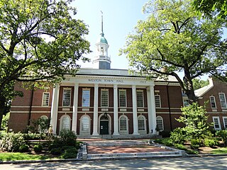
Weston is a town in Middlesex County, Massachusetts, United States, located approximately 15 miles (24 km) west of Boston. At the time of the 2020 United States Census, the population of Weston was 11,851.
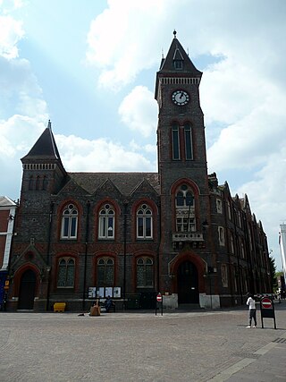
West Berkshire is a unitary authority area in the ceremonial county of Berkshire, England. It is administered from Newbury by West Berkshire Council.

Somerville is a town on the Mornington Peninsula in Melbourne, Victoria, Australia, 49 km (30 mi) south-east of Melbourne's Central Business District, located within the Shire of Mornington Peninsula local government area. Somerville recorded a population of 11,767 at the 2021 census.

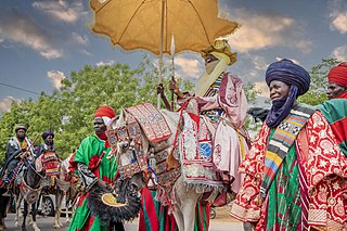
Gombe State is a state in northeastern Nigeria, bordered to the north and northeast by the states of Borno for 93 km in the vicinity of Gongola River and Lake Dadin Kowa and Yobe in the vicinity of Gongola River for 140 km, to the south by Taraba State for 58 km, to the southeast by Adamawa State for 95 km, and to the west by Bauchi State for 277 km. Gombe is the state capital of Gombe state and it was formed from a part of Bauchi State on 1 October 1996. Of the 36 states in Nigeria, Gombe is the 21st largest in area and the 32nd most populous, with an estimated population of about 3.25 million as of 2016. The state bears a slogan "Jewel in the Savannah".

Tumakuru district is an administrative district in the state of Karnataka in India. It is the third largest district in Karnataka by land area with an area of 10,598 km2, and fourth largest by Population. It is a one-and-a-half-hour drive from Bengaluru, the state capital. The district is known for the production of coconuts and is also called as 'Kalpataru Nadu'. It is the only discontiguous district in Karnataka.

Bauchi is a city in northeast Nigeria, the Administrative center of Bauchi State, of the Bauchi Local Government Area within that State, and of the traditional Bauchi Emirate. It is located on the northern edge of the Jos Plateau, at an elevation of 616 m. The Local Government Area covers an area of 3,687 km2 and had a population of 493,810 in 2006.

Bauchi State is a state in the North-East geopolitical zone of Nigeria, bordered by Jigawa to the north, Yobe to the northeast, Gombe to the east, Taraba and Plateau to the south, Kaduna to the west and Kano to the northwest. It takes its name from the historic town of Bauchi, which also serves as its capital city. The state was formed in 1976 when the former North-Eastern State was broken up. It originally included the area that is now Gombe State, which became a distinct state in 1996.
Jigawa State is one of the 36 states of Nigeria, located in the northern region of the country. Created on 27 August 1991, under the General Ibrahim Babangida administration who announced the creation of nine additional states in the country bringing the total number of states then to thirty. The announcement was given a legal backing through the; State Creation and Transitional Provisions Decree No. 37 of 1991. Jigawa State was a part of Kano State and was located in the northeastern-most region of Kano State, and it forms part of Nigeria's national border with the Republic of Niger. The state capital and largest city is Dutse. Jigawa state has 27 local governments

Katagum is a town, a local government area and a traditional emirate in Bauchi State of north eastern Nigeria. The town is located on the northern bank of the Jama'are River, which is a tributary of the Hadejia. Most of the inhabitants are peoples from the Fulani, Kanuri, Karai-karai and Hausa tribes. The chief agricultural products include peanuts (groundnuts), sorghum, millet, rice, cowpeas, cotton, indigo, and gum arabic. Livestock include horses, cattle, goats, sheep, donkeys and a lot of poultry.
Abdul Ahmed Ningi was a Deputy Majority Leader of the Nigerian Senate. A member of People's Democratic Party (PDP), he served as a Senator representing Bauchi central senatorial district from 2011 to 2015. Bauchi Central senatorial zone includes the local government areas of Danbam, Darazo, Ganjuwa, Misau, Ningi, and Warji.
Dambam is a Local Government Area of Bauchi State, Nigeria. Its administrative headquarter is located in the town of Dambam. It has two district Dagauda and Jalam
Darazo is a Local Government Area of Bauchi State, Nigeria, Its headquarters are in the town of Darazo. Darazo is mainly dominated by Fulani and Karai-karai people.
Zaki is a Local Government Area of Bauchi State, Nigeria. Its headquarters are in the town of Katagum.

The A237 highway is a highway in Nigeria. It is one of the East-West roads linking the main south-north roads..
Joshua Mamman Madaki was Governor of Bauchi State, Nigeria from December 1987 to August 1990 and then of Plateau State from August 1990 to January 1992 during the military regime of Major General Ibrahim Babangida.
Kafin Madaki is the headquarters of Ganjuwa Local Government Area of Bauchi State, Nigeria. It is a small town of about 20,000 people some 45 km north of Bauchi. The economy is based primarily on farming, with cottage industries in weaving, iron-working, soap-making and brick-making. Water supply is based on boreholes. In March 2008 the Bauchi state government started reconstruction of the General Hospital at Kafin Madaki, which had fallen into disrepair. The state Commissioner of Health inspected the construction of the new hospital in May 2010, and announced plans to hire additional medical personnel.

South Salmara-Mankachar is an administrative district in the state of Assam in India. The district headquarter is located at Hatsingimari village which is situated at about 245 km from Guwahati. It was earlier a sub-division of the Dhubri District.

The 2023 Bauchi State gubernatorial election took place on 18 March 2023, to elect the Governor of Bauchi State, concurrent with elections to the Bauchi State House of Assembly as well as twenty-seven other gubernatorial elections and elections to all other state houses of assembly. The election—which was postponed from its original 11 March date—was held three weeks after the presidential election and National Assembly elections. Incumbent PDP Governor Bala Mohammed initially declined to run for re-election, instead running for president. However, after losing the PDP presidential primary in May 2022, Mohammed was renominated in a rerun primary. Mohammed was re-elected as governor by a 9% margin over first runner-up and APC nominee — former Chief of the Air Staff Sadique Abubakar.

The 2023 Nigerian presidential election in Bauchi State was held on 25 February 2023 as part of the nationwide 2023 Nigerian presidential election to elect the president and vice president of Nigeria. Other federal elections, including elections to the House of Representatives and the Senate, will also be held on the same date while state elections will be held two weeks afterward on 11 March.

