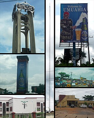
Umuahia is the capital city of Abia State in southeastern Nigeria. Umuahia is located along the rail road that lies between Port Harcourt to its south,and Enugu city to its north. Umuahia has a population of 359,230 according to the 2006 Nigerian census. Umuahia is indigenously Igbo.
Yenagoa is a Local Government Area and capital city of Bayelsa State, Southern Nigeria. It is located at the Niger-Delta region of the country at coordinates 4°55′29″N6°15′51″E.

Ningi is a town, a local government area, and an emirate in Bauchi State, Nigeria. The Ningi emirate comprises two local government areas, Ningi and Warji, with a combined area of 5,250 km2 and a population of 501,912 according to the 2006 Census. The Ningi local government area covers an area of 4,625 km2 with a population of 387,192 at the 2006 Census. The area is inhabited mostly by hausa people, Duwa, Ningawa.Yunusa Muhammadu Danyaya is the current Emir of Ningi.

Gboko is a Local Government Area in Benue state, North-central Nigeria. It is headquartered in the town of Gboko.
Bakori is a local government area in Katsina State, Nigeria. It was created on 15 May 1989 by the then military governor of Katsina State Major General Lawrence Onoja
Bende is a Local Government Area in Abia State, Nigeria with headquarters located in Bende Community. Bende Local Government Area (L.G.A) of Abia state lies on 70 30I of the Greenwich Meridian and latitude 50 30I North of the Equator. It is composed of thirteen (13) communities, namely: Alayi, Bende, Ezukwu, Igbere, Item, Itumbuzo, Nkpa, Ntalakwu, Ozuitem, Ugwueke, Umu-imenyi, Umuhu-Ezechi, and Uzuakoli.
Ankpa is a Local Government Area in Kogi State, Nigeria. Its headquarters are in the town of Ankpa on the A233 highway in the west of the area at7°22′14″N7°37′31″E.
Demsa is a Local Government Area of Adamawa State, Nigeria with headquarters located in Demsa. Demsa lies on the Benue River.
Shelleng is a Local Government Area (LGA) of Adamawa State, North-east Nigeria.
Darazo is a Local Government Area of Bauchi State, Nigeria, Its headquarters are in the town of Darazo. Darazo is mainly dominated by Fulani and Karai-karai people.
Gubio, also Gobiyo, is a Local Government Area of Borno State, in northeastern Nigeria. Its headquarters are in the town of Gubio.
Shani is a Local Government Area of Borno State, Nigeria. Its headquarters are in the town of Shani.

Nafada is one of the eleven Local Government Areas (LGA) of Gombe State, Nigeria. Its headquarter is in the town of Nafada in the east of the area at 11°05′44″N11°19′58″E, on the Gongola River which traverses the area. According to the 2006 census, the LGA covers 1,586 square kilometers and has a population of 138,185 people. Nafada has ten wards namely: Nafada East, Nafada Central, Nafada West, Jigawa, Birnin Fulani East, Birnin Bolewa, Birnin Fulani West, Gudukku, Barwo/Nasarawo and Barwo Winde.
Bagudo is a Local Government Area in Kebbi State, Nigeria, sharing a boundary with the Republic of Niger and Republic of Benin. Its headquarters are in the town of Bagudo.
Bunza is a Local Government Area (LGA) in Kebbi State, Nigeria. Its headquarters are in the town of Bunza and was created in 1975 out of the then-state of Sokoto during the local government reform under the General Murtala administration. Bunza shares bounders in the east with Kalgo LGA, the latter was created in 1996 out of the present Bunza; in the north with Dandi and Arewa LGA's; and in the south and west with Suru Local Government Area, the latter was created in 1991 out of Bunza.
Kankia is a Local Government Area in Katsina State, Nigeria. and has its headquarters is in the town of Kankia on Kano - Katsina road A9 highway at12°32′57″N7°49′31″E.. Towns and villages that make up Kankia Local Government Area include Kafin Dangi, Sukuntuni, Rimaye, Sabuwar Duniya, Tafashiya, Gaza, Kafin-soli, and Kankia. The population of Kankia Local Government Area is estimated at 151,434 inhabitants at the 2006 census with the majority of the area’s dwellers being members of the Hausa and the Fulani ethnic divisions. The Hausa and the Fufulde languages are widely spoken in the area with Islam as the LGA’s most practiced religion. The paramount traditional ruler in Kankia LGA is the Hakimi Kankia while notable landmarks in the area include the Kankiya Iro School of Hecalth Technology, Kankia and the Kankia General Hospital. The postal code of the area is 822
Kauru is a Local Government Area in southern Kaduna State, Nigeria. The area is 3,186 km2. Its headquarters are in the town of Kauru. The postal code of the area is 811.

Keffi Local Government Area and also is a traditional or commercial town in Nasarawa north central Nigeria Its headquarters are in the town of Keffi. Keffi is 50 kilometers from Abuja. Nasarawa State university is located in Keffi sitting along Keffi-Akwanga express way.
Bukkuyum is a Local Government Area in Zamfara State, Nigeria. Its headquarters is in the town of Bukkuyum. In March 2017 more than 300 children died of Lead poisoning from illegal mining site at yar Galma village at12°08′00″N5°28′00″E in the north-west of the area.
Nangere is a Local Government Area in Yobe State, Nigeria. It has its headquarters in the town of Sabon Garin Nangere.

