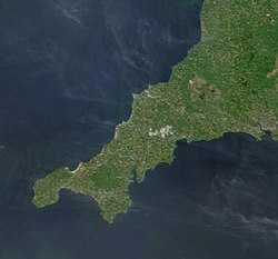
Geography of Cornwall

Last updated

Geography of Cornwall
Cw2.jpg
ContinentEurope
IslandGreat Britain
Coordinates 50°18′N4°54′W / 50.3°N 4.9°W / 50.3; -4.9
Area Ranked 9th out of 82 counties
3,563 km² (1,376 mi²)
Coastline697 km (422 mi)
Highest point Brown Willy
420 m (1,378 ft)
Lowest pointSea level
Longest river River Tamar (border)
94 km (58 mi)
River Camel (within Cornwall)
50 km (31 mi)
Largest lake The Loe

The geography of Cornwall (Cornish : Doronieth Kernow) describes the extreme southwestern peninsula of England west of the River Tamar. The population of Cornwall is greater in the less extensive west of the county than the east due to Bodmin Moor's location; however the larger part of the population live in rural areas. It is the only county in England bordered by only one other county, Devon, and is the 9th largest county by area, encompassing 3,563 km² (1,376 mi²). The length of the coast is large in proportion to the area of the county. Cornwall is exposed to the full force of the prevailing south-westerly winds that blow in from the Atlantic Ocean. To the north is the Celtic Sea, and to the south the English Channel.

Contents

Cornwall is the location of Great Britain's most southerly point, The Lizard, and the southern mainland's most westerly point, Land's End. A few miles further west are the Isles of Scilly.

Physical geography

Cornwall is located at 50°30′N5°00′W / 50.5°N 5°W / 50.5; -5 . The highest point is Brown Willy at 420 m (1,378 ft), part of the granite Bodmin Moor, of which such intrusions are covered by rough grass, heather and bog flora. Woodland is prevented from growing on the granite uplands because of the poor soil and the height giving them the full force of the wind and climate. The rest of the inland contains pastureland and arable farmland. The coastline, at 697 km (422 mi) , [1] is mostly occupied by high cliffs, but also featuring islets, stacks, coves and bays. Lowland stretches are also to be found, particularly along the south coast, sometimes backed by large expanses of towans or dunes such as near Par. The Isles of Scilly are the largest archipelago in the British Isles outside Scotland. The largest other islands are off the south coast: Looe Island and St Michael's Mount.

The sea to the north of Cornwall is the Celtic Sea; before the usage of Celtic Sea it was part of the Bristol Channel. On Joel Gascoyne's map of 1699 this part of the Atlantic Ocean was named "The North Sea or Severn Channel". [2]

Cornwall was one of the most important mining areas in Europe until the 20th century, due to its intrusions of granite into surrounding sedimentary rocks which resulted in metamorphism and mineralisation. Bodmin Moor and Carn Brea are examples of such granite intrusion. The Lizard peninsula is an example of an ophiolite.

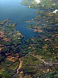
The north coast is more exposed to the prevailing winds from the Atlantic Ocean than the south coast and is more rugged, with many sheer cliffs and steep valleys. The south coast is more sheltered and is interrupted by several rias which provide deep water harbours such as Carrick Roads.

Cornwall has varied habitats including terrestrial and marine ecosystems. One of the lower plant forms in decline locally is the Reindeer lichen, which has been made a priority for protection under the national UK Biodiversity Action Plan.

National character areas

The national character areas recognised by Natural England that lie wholly or partially on Cornish soil are:

Hills

Human geography

One of the oldest maps still in existence depicting Cornwall is the 1290 Hereford Mappa Mundi currently on display in Hereford Cathedral in the United Kingdom. Many maps of the British Isles prior to the 17th century showed Cornwall (Cornubia/Cornwallia/Kernow) as a nation on a par with Wales and examples include the maps of Sebastian Münster, Abraham Ortelius, and Girolamo Ruscelli. After the 17th century, maps of Cornwall tended to no longer make the distinction between Anglia and Cornubia, the British Sea was renamed the English Channel and Cornwall as a separate entity was omitted from the maps.

The view northwest from Carn Brea, Penwith View northwest from Carn Brea, Penwith - geograph.org.uk - 40696.jpg
The view northwest from Carn Brea, Penwith

From 1889 to March 2009 Cornwall was administered by Cornwall County Council; the second level of local government included municipal boroughs, urban districts and rural districts, and within each of these were a number of civil parishes. Cornwall consisted from April 1974 to March 2009 of six districts, which are, from west to east: Penwith, Kerrier, Carrick, Restormel, North Cornwall, and Caradon. While traditionally administered as part of Cornwall, the Isles of Scilly are now a separate unitary authority though they are included in the ceremonial county. Natural resources include: granite, slate, tin, copper and kaolinite. Agricultural land: 73.64%; Woodland cover: 7.5%; Other types: 18.86%. The deposits of tin, copper and kaolinite were heavily exploited during the 19th and 20th centuries. Some species of fish are abundant in the coastal waters; the pilchard fishery was of great importance from the late 18th to the early 20th century.

Camborne is the county's largest town and more populous than the capital Truro. Together with the neighbouring town of Redruth, it forms the largest urban area in Cornwall, and both towns were significant as centres of the global tin mining industry in the 19th century; nearby copper mines were also very productive during that period. St Austell is also larger than Truro and was the centre of the china clay industry in Cornwall. Until four new parishes were created for the St Austell area on 1 April 2009 St Austell was the largest settlement in Cornwall. [3]

Climate

Cornwall has a temperate Oceanic climate (Köppen climate classification: Cfb), with mild winters and cool summers, and hot weather is rare. Cornwall has the mildest and sunniest climate in the United Kingdom, as a result of its oceanic setting and the influence of the Gulf Stream. [4] The average annual temperature in Cornwall ranges from 11.6 °C (53 °F) on the Isles of Scilly to 9.8 °C (50 °F) in the central uplands. Winters are amongst the warmest in the country, due to the moderating effects of the warm ocean currents, and frost and snow are very rare at the coast and are also rare in the central upland areas. Summers are, however, not as warm as those of other areas in southern England. The surrounding sea and its southwesterly position mean that Cornwall's weather is relatively changeable.

Cornwall is one of the sunniest areas in the UK, with over 1541 hours of sunshine per year, with the highest average of 7.6 hours of sunshine per day in July. [5] The moist, mild air coming from the south west brings higher amounts of rainfall than in eastern Great Britain, at 1051 to 1290 mm (41.4 to 50.8 in) per year, though not as much as in more northern areas of the west coast. [6] The Gulf Stream moderates the climate of Cornwall enough that Cornwall's weather is distinctly milder than other places in the world at the same latitude, such as Newfoundland. The mild climate has resulted in a number of botanical gardens, such as Trebah and the Lost Gardens of Heligan.

The Isles of Scilly, for example, is the warmest place in the whole of Great Britain with an average temperature of 11.6 °C, where there are on average less than two days of air frost per year, are in the USDA Hardiness zone 10, which is thus the only area in the UK that is in this zone. However, compared to most other climates in zone 10, Scilly has cool summers. In Scilly there is on average less than one day of air temperature exceeding 30 °C per year and it is in the AHS Heat Zone 1. Pendennis Point in Falmouth is the warmest place on mainland Great Britain, with an average temperature of 11.4 °C (52.5 °F). [7]

Extreme temperatures in Cornwall are particularly rare; however, extreme weather in the form of storms and floods is common. The Shipping Forecast areas bordering on Cornwall are Lundy (north coast) and Plymouth (south coast).

Temperature tables

Climate data for Bude
MonthJanFebMarAprMayJunJulAugSepOctNovDecYear
Average high °C (°F)9
(48)
9
(48)
10
(50)
12
(54)
16
(61)
18
(64)
20
(68)
20
(68)
19
(66)
15
(59)
12
(54)
10
(50)
14
(57)
Average low °C (°F)4
(39)
3
(37)
4
(39)
5
(41)
8
(46)
10
(50)
14
(57)
13
(55)
11
(52)
9
(48)
6
(43)
5
(41)
8
(46)
Source: Weather Channel [8]
Climate data for Helston
MonthJanFebMarAprMayJunJulAugSepOctNovDecYear
Average high °C (°F)9
(48)
9
(48)
10
(50)
12
(54)
15
(59)
17
(63)
19
(66)
20
(68)
18
(64)
15
(59)
11
(52)
9
(48)
13
(55)
Average low °C (°F)4
(39)
4
(39)
5
(41)
6
(43)
8
(46)
11
(52)
13
(55)
14
(57)
11
(52)
9
(48)
6
(43)
5
(41)
8
(46)
Source: Weather Channel [9]
Climate data for Isles of Scilly, Cornwall
MonthJanFebMarAprMayJunJulAugSepOctNovDecYear
Average high °C (°F)10
(50)
9
(48)
11
(52)
12
(54)
14
(57)
17
(63)
19
(66)
19
(66)
18
(64)
16
(61)
13
(55)
11
(52)
14.1
(57.4)
Average low °C (°F)7
(45)
6
(43)
7
(45)
8
(46)
9
(48)
12
(54)
13
(55)
14
(57)
13
(55)
11
(52)
9
(48)
8
(46)
9.7
(49.5)
Average precipitation mm (inches)91
(3.6)
71
(2.8)
69
(2.7)
46
(1.8)
56
(2.2)
49
(1.9)
61
(2.4)
64
(2.5)
67
(2.6)
80
(3.1)
96
(3.8)
94
(3.7)
844
(33.2)
Average precipitation days221716131414161516171921200
Mean monthly sunshine hours 618313518622922923822516412177571,805
Source: Climate Data for Isles of Scilly [10]
Climate data for Liskeard
MonthJanFebMarAprMayJunJulAugSepOctNovDecYear
Average high °C (°F)8
(46)
8
(46)
9
(48)
12
(54)
14
(57)
18
(64)
20
(68)
20
(68)
19
(66)
15
(59)
11
(52)
9
(48)
14.5
(58.1)
Average low °C (°F)4
(39)
3
(37)
4
(39)
5
(41)
8
(46)
11
(52)
13
(55)
14
(57)
11
(52)
9
(48)
7
(45)
5
(41)
9
(48)
Source: Weather Channel [11]
Climate data for Truro, Cornwall
MonthJanFebMarAprMayJunJulAugSepOctNovDecYear
Average high °C (°F)8
(46)
8
(46)
10
(50)
12
(54)
15
(59)
18
(64)
19
(66)
20
(68)
18
(64)
15
(59)
12
(54)
9
(48)
14
(57)
Average low °C (°F)5
(41)
4
(39)
5
(41)
6
(43)
8
(46)
11
(52)
13
(55)
14
(57)
12
(54)
10
(50)
7
(45)
6
(43)
8
(47)
Average precipitation mm (inches)81
(3.2)
63
(2.5)
49
(1.9)
54
(2.1)
40
(1.6)
47
(1.9)
48
(1.9)
51
(2.0)
57
(2.2)
87
(3.4)
87
(3.4)
78
(3.1)
742
(29.2)
Source: Foreca [12]

Natural hazards

Cornwall seen from the International Space Station Cornwall from the International Space Station.JPG
Cornwall seen from the International Space Station

Cornwall is not known for being prone to natural hazards, although they do happen. The county experiences droughts and heat waves with the rest of Europe as they happen, but its location close to the ocean dampens their severity. Also, European windstorms in the winter usually make landfall on the west coast of Europe, including Cornwall, resulting in severe gales and flooding. Cornwall's many valleys also make it prone to rapid flooding when an unusually heavy amount of rainfall occurs, as seen in the Boscastle flood of 2004.

Although not lying on any plate boundary, Britain occasionally experiences intraplate tremors as a result of the Eurasian Plate's motion, reactivating weak points in the rock. The west coast is more prone to these tremors than the east. [13] The strongest tremor so far recorded in Cornwall was in 1815, measuring 4.4 on the Richter scale with its epicentre near Penzance. [14]

The 1755 earthquake in Lisbon, Portugal which measured 9.0 on the Richter scale sent a tsunami towards the south coast of Cornwall. Historical accounts describe the waves of 3 metres (10 feet) in height and significant loss of life and property. [15]

See also

Cornish heath Erica vagans (aka).jpg
Cornish heath
Crackington Haven seen across the beach in 2005 CrackingtonHavenCornwall.jpg
Crackington Haven seen across the beach in 2005
Bluebells on the Cornish coast Bluebells on the Cornish Coast line.jpg
Bluebells on the Cornish coast

Related Research Articles

<span class="mw-page-title-main">Cornwall</span> County of England

Cornwall is a ceremonial county in South West England. It is recognised as one of the Celtic nations and is the homeland of the Cornish people. The county is bordered by the Atlantic Ocean to the north and west, Devon to the east, and the English Channel to the south. The largest settlement is Falmouth, and the county town is Truro.

<span class="mw-page-title-main">Devon</span> County of England

Devon is a ceremonial county in South West England. It is bordered by the Bristol Channel to the north, Somerset and Dorset to the east, the English Channel to the south, and Cornwall to the west. The city of Plymouth is the largest settlement, and the city of Exeter is the county town.

<span class="mw-page-title-main">South West England</span> Region of England

South West England, or the South West of England, is one of the nine official regions of England in the United Kingdom. It consists of the counties of Cornwall, Dorset, Devon, Gloucestershire, Somerset and Wiltshire. Cities and large towns in the region include Bath, Bristol, Bournemouth, Cheltenham, Exeter, Gloucester, Plymouth and Swindon. It is geographically the largest of the nine regions of England covering 9,200 square miles (23,800 km2), but the third-least populous, with approximately five million residents.

A stannary was an administrative division established under stannary law in the English counties of Cornwall and Devon to manage the collection of tin coinage, which was the duty payable on the metal tin smelted from the ore cassiterite mined in the region. In Cornwall, the duty was passed to the Duchy of Cornwall; in Devon to the Crown.

<span class="mw-page-title-main">Geography of England</span> Geographical features of England

England comprises most of the central and southern two-thirds of the island of Great Britain, in addition to a number of small islands of which the largest is the Isle of Wight. England is bordered to the north by Scotland and to the west by Wales. It is closer to continental Europe than any other part of mainland Britain, divided from France only by a 33 km (21 mi) sea gap, the English Channel. The 50 km (31 mi) Channel Tunnel, near Folkestone, directly links England to mainland Europe. The English/French border is halfway along the tunnel.

<span class="mw-page-title-main">Mining in Cornwall and Devon</span> Mining in the English counties of Cornwall and Devon

Mining in Cornwall and Devon, in the southwest of Britain, is thought to have begun in the early-middle Bronze Age with the exploitation of cassiterite. Tin, and later copper, were the most commonly extracted metals. Some tin mining continued long after the mining of other metals had become unprofitable, but ended in the late 20th century. In 2021, it was announced that a new mine was extracting battery-grade lithium carbonate, more than 20 years after the closure of the last South Crofty tin mine in Cornwall in 1998.

<span class="mw-page-title-main">Seven Stones Reef</span> Rocky reef offshore of Lands End, Cornwall

The Seven Stones reef is a rocky reef nearly 15 miles (24 km) west of Land's End, Cornwall and 7 miles (11 km) east-northeast of the Isles of Scilly. The reef consists of two groups of rocks and is nearly 2 miles (3.2 km) long and 1 mile (1.6 km) in breadth. They rise out of deep water and are a navigational hazard for shipping with 71 named wrecks and an estimated 200 shipwrecks overall. The most infamous is the Torrey Canyon in 1967, which was at that time the world's costliest shipping disaster, and to date, still the worst oil spill on the coast of the United Kingdom.

<span class="mw-page-title-main">Geology of Cornwall</span>

The geology of Cornwall, England, is dominated by its granite backbone, part of the Cornubian batholith, formed during the Variscan orogeny. Around this is an extensive metamorphic aureole formed in the mainly Devonian slates that make up most of the rest of the county. There is an area of sandstone and shale of Carboniferous age in the north east, and the Lizard peninsula is formed of a rare section of uplifted oceanic crust.

<span class="mw-page-title-main">Economy of Cornwall</span> Regional economy

The economy of Cornwall in South West England is largely dependent upon agriculture, followed by tourism. Cornwall is one of the poorest areas in the United Kingdom with a GVA of 70.9% of the national average in 2015. It is one of four areas in the UK that qualified for poverty-related grants from the EU. Farming and food processing contributed £366 million to the county's economy in 2006, equal to 5.3% of Cornwall’s total GVA. The agriculture industry in Cornwall employed 9,500 people as of 2011. 23,700 more were employed in the food industry in Cornwall. The Cornish economy also depends heavily on its successful tourist industry, which contributes 12% of Cornwall's GDP and supports about 1 in 5 jobs. Tourism contributed £1.85 billion to the Cornish economy in 2011.

<span class="mw-page-title-main">Cornish Main Line</span> Railway line in Cornwall, England

The Cornish Main Line is a railway line in Cornwall and Devon in the United Kingdom. It runs from Penzance to Plymouth, crossing from Cornwall into Devon over the famous Royal Albert Bridge at Saltash.

This timeline summarizes significant events in the History of Cornwall

<span class="mw-page-title-main">Transport in Cornwall</span>

The evolution of transport in Cornwall has been shaped by the county's strong maritime, mining and industrial traditions and much of the transport infrastructure reflects this heritage.

<span class="mw-page-title-main">Flora and fauna of Cornwall</span>

Cornwall is the county that forms the tip of the southwestern peninsula of England; this area has a mild and warm climate regulated by the Gulf Stream. The mild climate allows rich plant cover, such as palm trees in the far south and west of the county and in the Isles of Scilly, due to sub-tropical conditions in the summer.

<span class="mw-page-title-main">Isles of Scilly</span> Group of islands off the south-westernmost point of mainland Britain

The Isles of Scilly is an archipelago off the southwestern tip of Cornwall, England, United Kingdom. One of the islands, St Agnes, is the most southerly point in the British Isles, being over four miles further south than the most southerly point of the British mainland at Lizard Point.

<span class="mw-page-title-main">Climate of south-west England</span> Typical climate of South-West England

The climate of south-west England is classed as oceanic (Cfb) according to the Köppen climate classification. The oceanic climate is typified by frequent cloudy skies, cool winters with cool summers and precipitation all year round, with more experienced in winter. Annual rainfall is about 1,000 millimetres (39 in) and up to 2,000 millimetres (79 in) on higher ground. Exceptions include areas to the east of high ground ( e.g. Exeter / parts of West Somerset that are subject to a rain shadow effect and annual rainfall is closer to 30 inches.

<span class="mw-page-title-main">Cornubian batholith</span> Granite rock in southwest England

The Cornubian batholith is a large mass of granite rock, formed about 280 million years ago, which lies beneath much of Cornwall and Devon in the south-western peninsula of Great Britain. The main exposed masses of granite are seen at Dartmoor, Bodmin Moor, St Austell, Carnmenellis, Land's End and the Isles of Scilly. The intrusion is associated with significant quantities of minerals particularly cassiterite, an ore of tin which has been mined since about 2000 BC. Other minerals include china clay and ores of copper, lead, zinc and tungsten.

<span class="mw-page-title-main">Cornwall Area of Outstanding Natural Beauty</span> Designated coastal areas and a moorland in southwesternmost county of England

The Cornwall Area of Outstanding Natural Beauty covers 958 square kilometres (370 sq mi) in Cornwall, England, UK; that is, about 27% of the total area of the county. It comprises 12 separate areas, designated under the National Parks and Access to the Countryside Act 1949 for special landscape protection. Of the areas, eleven cover stretches of coastline; the twelfth is Bodmin Moor. The areas are together treated as a single Area of Outstanding Natural Beauty (AONB).

<span class="mw-page-title-main">Outline of Cornwall</span> Overview of and topical guide to Cornwall

The following outline is provided as an overview of and topical guide to Cornwall: Cornwall – ceremonial county and unitary authority area of England within the United Kingdom. Cornwall is a peninsula bordered to the north and west by the Celtic Sea, to the south by the English Channel, and to the east by the county of Devon, over the River Tamar. Cornwall is also a royal duchy of the United Kingdom. It has an estimated population of half a million and it has its own distinctive history and culture.

Presented below is an alphabetical index of articles related to Cornwall:

<span class="mw-page-title-main">Joel Gascoyne</span> English cartographer and surveyor

Joel Gascoyne was an English nautical chartmaker, land cartographer and surveyor who set new standards of accuracy and pioneered large scale county maps. After achieving repute in the Thames school of chartmakers, he switched careers and became one of the leading surveyors of his day and a maker of land maps. He is best known for his maps of the colonial Province of Carolina, of the county of Cornwall, and the early 18th-century Parish of Stepney, precursor of today's East End of London. Gascoyne's distinctive style of chart and map-drawing was characterised by the use of bold and imaginative cartouches.

References

  1. Cornwall County Council – Profile of the Cornish Landscape Archived 10 February 2007 at the Wayback Machine
  2. Gascoyne, Joel A Map of the County of Cornwall, 1699; reprinted in facsimile with an introduction by William L. D. Ravenhill and O. J. Padel (Devon and Cornwall Record Society: new series; vol. 34.); Exeter: Devon and Cornwall Record Society, 1991
  3. "Town and parishes to get councils". BBC News website. BBC. 5 December 2008. Retrieved 6 December 2008.
  4. Met Office, 2000. Annual average temperature for the United Kingdom Archived 4 March 2010 at the Wayback Machine .
  5. Met Office, 2000. Annual average sunshine for the United Kingdom Archived 4 March 2010 at the Wayback Machine .
  6. Met Office, 2000. Annual average rainfall for the United Kingdom Archived 4 March 2010 at the Wayback Machine .
  7. Ash, Russell (2006). The Top 10 of Everything 2007. Hamlyn. ISBN   978-0-600-61532-3.
  8. Bude travel information Weather Channel UK Retrieved 4 April 2009
  9. Helston travel information Weather Channel UK Retrieved 4 April 2009
  10. "Average Weather for Isles of Scilly, ENG — Temperature and Precipitation". Archived from the original on 11 July 2010.
  11. Liskeard travel information Weather Channel UK Retrieved 4 April 2009
  12. "Weather Averages - Truro, England". Foreca. Archived from the original on 30 September 2011. Retrieved 20 May 2008.
  13. Earthquake shakes south west England – BBC News
  14. Earthquakes in the South West – South West Observatory
  15. First of November, the Earthquake day – Oliver Wendell Holmes Archived 31 December 2007 at the Wayback Machine

Further reading