Gippsland Plains Grassy Woodland

Last updated

Gippsland Plains Grassy Woodland
Yumbungalake.jpg
Ecology
Realm Australasia
Biome Temperate grasslands, savannas, and shrublands
Borders
Geography
Area60,000 km2 (23,000 sq mi)
CountryAustralia
Elevation20–100 metres (66–328 ft)
Coordinates 38°06′S147°06′E / 38.1°S 147.10°E / -38.1; 147.10 Coordinates: 38°06′S147°06′E / 38.1°S 147.10°E / -38.1; 147.10
Climate type Oceanic climate (Cfb)
Soil types Clay loam

The Gippsland Plains Grassy Woodland is an ecological temperate grassland community located in the Gippsland region in southern Victoria, Australia. Stretching from Bairnsdale in the east to the eastern portion of Melbourne in the west, they typify one of Victoria's most threatened and disconnected indigenous ecosystems. The Gippsland Red Gum Grassy Woodland is the most prominent community in the system situated in the centre. [1] [2]

Contents

Situated in the South East Coastal Plain, the Gippsland grasslands consist of South Gippsland Plains Grassland (east), Central Gippsland Plains Grasslands (centre) and Forest Red Gum Grassy Woodland (west) in southern Victoria, where they border Victorian Volcanic Plain grasslands in the west. [3]

Geography

The Gippsland Railway traverses the grassy woodland. Vicrailmap-gippsland.png
The Gippsland Railway traverses the grassy woodland.

The vegetation community was once ubiquitous across the Gippsland plain, but now only less than five per cent of its original extent remains, partly consisting of sporadic vegetation areas encircled by a mostly cleared, farming landscape. The zone is bounded by the Strzelecki Ranges to the west, the Great Dividing Range to the north and the Mornington Peninsula to the east, reaching Cranbourne and Westernport in Melbourne's east. The community caters to many nationally and state-listed threatened plants and animals. [4]

The open grasslands of the Central Gippsland Plains used to cover about 600 km2 of land and the Forest Red Gum Grassy Woodland around 1200 km2 at the time of European settlement, but are now most likely nonexistent. The Forest Red Gum Grassy Woodland is situated on Lower Pleistocene gravels, sands, silts and clays, with some Tertiary alluvium. [3]

The community is situated on undulating to generally flat plains that are less than 100 metres above sea level, with some presence on low hills up to 220 metres. There used to be a tree canopy, but it has mostly been cleared. Shrubs are thinly distributed in both forms, with a cover of less than 10 per cent. However, despite being mostly cleared, the community is still sparsely present on roadsides or railways, cemeteries and nature reserves. [1]

Annual rainfall typically ranges between 570 mm and 650 mm, and elevation is relatively low at 20–40 m above sea level. [3]

Ecology

Trees

The Avon River within the grassy woodlands VM 0258 Stratford - Avon River.jpg
The Avon River within the grassy woodlands

The Gippsland Red Gum Grassy Woodland ecoregion is so named because Eucalyptus tereticornis is prevalent, in addition to Eucalyptus bridgesiana, Eucalyptus camaldulensis, Eucalyptus globoidea, Eucalyptus angophoroides, Eucalyptus bosistoana, Eucalyptus pauciflora, Eucalyptus melliodora and Eucalyptus polyanthemos, as well as patches of Allocasuarina littoralis, Acacia implexa, Acacia mearnsii and Allocasuarina verticillata. The South Gippsland Plains Grassland is located at wetter sites with poor soil to the south and west of the central Gippsland plain, from coastal Gippsland in the south to Traralgon, where it features thinly scattered eucalypts, such as Eucalyptus ovata and Eucalyptus viminalis. Furthermore, the New Zealand native Kunzea ericoides has invaded some parts of the grassland. [1]

Groundcover

The groundcover features many different wildflowers, including Arthropodium strictum, Chrysocephalum apiculatum and Xerochrysum palustre, Dianella revoluta, Diuris punctata, Acaena echinata, Hypericum gramineum, Dianella amoena, Chrysocephalum apiculatum, Dichondra repens, Drosera peltata, Hydrocotyle laxiflora, Poranthera microphylla, Thysanotus patersonii, Tricoryne elatior and Wurmbea dioica, which inhabit the areas between tussocks. [3]

Grasses include tussock grasses such as Themeda triandra, and as well as Austrodanthonia laevis, Pentapogon quadrifidus, Wahlenbergia gracilis, Austrostipa, Hypoxis hygrometrica, Lomandra filiformis, Carex breviculmis, Microlaena stipoides, Schoenus apogon, Themeda triandra, Hemarthria uncinata var. uncinata, Lachnagrostis spp. and Juncus subsecundus. [1]

Animals

Animals include Lathamus discolor, Anthochaera phrygia, Litoria raniformis, Dasyurus maculatus and Isoodon obesulus. [1]

Related Research Articles

Belgrave Heights is a town in Melbourne, Victoria, Australia, 36 km south-east from Melbourne's central business district, located within the Shire of Yarra Ranges local government area. Belgrave Heights recorded a population of 1,398 at the 2021 census.

Scottsdale Reserve is a 1,328-hectare (3,280-acre) nature reserve on the Murrumbidgee River in south-central New South Wales, Australia. It is 79 kilometres (49 mi) south of Canberra, and 4 kilometres (2.5 mi) north of Bredbo. It is owned and managed by Bush Heritage Australia (BHA), which purchased it in 2006. The purchase was supportive of projects aiming to connect existing fragmented remnant habitat such as K2C. Since the 1870s up until 2006, the land was used for agriculture – primarily sheep grazing with some minor cropping. A significant component of the Reserve has been cleared of native vegetation.

<span class="mw-page-title-main">Southeast Australia temperate savanna</span>

The Southeast Australia temperate savanna ecoregion is a large area of grassland dotted with eucalyptus trees running north–south across central New South Wales, Australia.

<span class="mw-page-title-main">Mount Lofty woodlands</span> Ecoregion in South Australia

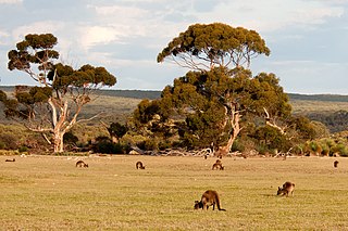
The Mount Lofty woodlands, or the Peppermint Box Grassy Woodland of South Australia, is an ecoregion in South Australia, which includes woodlands, shrublands, and grasslands in the Mount Lofty Ranges, Fleurieu Peninsula, and Kangaroo Island.

The Black Andrew Nature Reserve is a protected nature reserve located on the south west slopes of New South Wales, Australia. The 1,559-hectare (3,850-acre) reserve is situated on the southern shore of Burrinjuck Dam on the Murrumbidgee River, an important reservoir for the Murrumbidgee Irrigation Area.

<span class="mw-page-title-main">Western Sydney Regional Park</span> Park in Sydney

Western Sydney Regional Park is a large urban park and a nature reserve situated in Western Sydney, Australia within the suburbs of Horsley Park and Abbotsbury. A precinct of Western Sydney Parklands, a park system, and situated within the heart of the Cumberland Plain Woodland, the regional park features several picnic areas, recreational facilities, equestrian trails, and walking paths within the Australian bush.

The Queanbeyan Nature Reserve is a protected nature reserve that is located in the Southern Tablelands region of New South Wales, in eastern Australia. The 67-hectare (170-acre) reserve is situated approximately 4 kilometres (2.5 mi) west-south-west of the City of Queanbeyan.

<span class="mw-page-title-main">Cumberland Plain Woodland</span> Indigenous woodland community in Sydney, Australia

The Cumberland Plain Woodland, also known as Cumberland Plain Bushland and Western Sydney woodland, is a grassy woodland community found predominantly in Western Sydney, New South Wales, Australia, that comprises an open tree canopy, a groundcover with grasses and herbs, usually with layers of shrubs and/or small trees.

<span class="mw-page-title-main">Ecology of Sydney</span> Geographic aspect of Sydney, Australia

The ecology of Sydney, located in the state of New South Wales, Australia, is diverse for its size, where it would mainly feature biomes such as grassy woodlands or savannas and some sclerophyll forests, with some pockets of mallee shrublands, riparian forests, heathlands, and wetlands, in addition to small temperate rainforest fragments.

<span class="mw-page-title-main">Southeast Australia temperate forests</span> Terrestrial ecoregion in Australia

The Southeast Australia temperate forests is a temperate broadleaf and mixed forests ecoregion of south-eastern Australia. It includes the temperate lowland forests of southeastern Australia, at the southern end of the Great Dividing Range. Vegetation ranges from wet forests along the coast to dry forests and woodlands inland.

<span class="mw-page-title-main">Victorian Volcanic Plain grasslands</span> Ecological community in southern Victoria

The Victorian Volcanic Plain Grasslands are a critically endangered temperate grasslands that occur in the Australian state of Victoria, stretching from Hamilton in the northwest to the city of Melbourne. Part of the Southern Volcanic Plain and bordering the Gippsland Plains Grassy Woodland to the east, the grasslands sit on Cainozoic volcanic deposits. In 2011, the Victorian Government had reserved 15,000 hectares of land to protect the critically endangered community. Only less than 5% of the pre-European concentration of the grasslands remain.

<span class="mw-page-title-main">Iron-grass Natural Temperate Grassland of South Australia</span> Ecological community in South Australia

The Iron-grass Natural Temperate Grassland of South Australia is a temperate grassland in the southeast of South Australia that stretches from Orroroo in the north, to Strathalbyn in the south, just straddling the eastern fringes of Adelaide's Mount Lofty Ranges. Listed as Critically Endangered under the EPBC Act, the grasslands predominantly feature Iron-grasses.

<span class="mw-page-title-main">Northern Plains Grassland</span> Ecological community in northern Victoria

The Northern Plains Grassland (NPGL) is an open, shrubby temperate grassland community located in northern Victoria straddling the Murray Darling Depression and Wimmera, extending to the Riverina and South Western Slopes regions in southern New South Wales. Floristically rich, the area features 30 native plant species per 100 m2.

<span class="mw-page-title-main">Southern Tablelands Temperate Grassland</span> Ecological community in New South Wales

The Southern Tablelands Temperate Grassland, formally Natural Temperate Grassland of the Southern Tablelands, is a temperate grassland community situated in the Southern Tablelands and Monaro region of New South Wales, extending into the Australian Capital Territory and the Victorian border. Listed as Endangered under the Environment Protection and Biodiversity Conservation Act 1999, the grassland is dominated by reasonably tall, dense to open tussock grasses.

<span class="mw-page-title-main">New England Peppermint Grassy Woodland</span> Ecological community in New South Wales

The New England Peppermint Grassy Woodland is a grassy-woodland community primarily situated in the New England and Northern Tablelands regions in northern New South Wales, Australia. Named after the Eucalyptus nova-anglica, it is listed as a critically endangered ecological communities (TECs) under the Environment Protection and Biodiversity Conservation Act 1999.

<span class="mw-page-title-main">Shale Sandstone Transition Forest</span> Indigenous woodland community in Sydney, Australia

The Shale Sandstone Transition Forest, also known as Cumberland Shale-Sandstone Ironbark Forest, is a transitory ecotone between the grassy woodlands of the Cumberland Plain Woodlands and the dry sclerophyll forests of the sandstone plateaus on the edges of the Cumberland Plain in Sydney, Australia.

<span class="mw-page-title-main">Lowland Native Grasslands of Tasmania</span> Ecological community in southern Victoria

The Lowland Native Grasslands of Tasmania are a temperate grassland situated in the eastern portion of Tasmania, Australia. Listed as a critically endangered ecological community listed under the national environment law, they are dominated by kangaroo grass, velvet tussock grass and/or silver tussock grass.

References

  1. 1 2 3 4 5 Gippsland Red Gum Grassy Woodland and Associated Native Grassland Environment Protection and Biodiversity Conservation Act 1999. Retrieved 6 September 2022. CC-BY icon.svg Text was copied from this source, which is available under Creative Commons Attribution 4.0 International License.
  2. South East Coastal Plain Grasslands Biodiversity of South-Eastern Australia. Retrieved 6 September 2022.
  3. 1 2 3 4 Central Gippsland Plains Grassland, Forest Red Gum Grassy Woodland, Northern Plains Grassland, South Gippsland Plains Grassland, Western (Basalt) Plains Grassland Action Statement, Flora and Fauna Guarantee Act 1988 No. 182, Department of Sustainability and Environment. Retrieved 6 September 2022.
  4. Gippsland Red Gum Grassy Woodland and Associated Native Grassland Grasslands Biodiversity of South-Eastern Australia. Retrieved 6 September 2022.