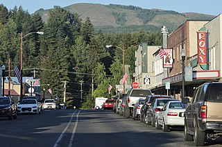
Morton is a city in Lewis County, Washington, United States. The population was 1,036 at the 2020 census.

The Cowlitz River is a river in the state of Washington in the United States, a tributary of the Columbia River. Its tributaries drain a large region including the slopes of Mount Rainier, Mount Adams, and Mount St. Helens.
Randle is a small town in eastern Lewis County, Washington, United States. Randle is located on U.S. Route 12 and is notable as the northeastern access point to the Mount St. Helens Windy Ridge viewpoint, by way of forest service roads that cut through the Gifford Pinchot National Forest.

Cougar is an unincorporated community and former town in Cowlitz County, Washington. Cougar is located around 30 miles (48 km) northeast of Woodland along Washington State Route 503 and situated along the northwest bank of Yale Lake, a reservoir on the Lewis River. The population of Cougar was 122 at the 1990 Census, when it was still incorporated as a town, but disincorporated before the 2000 Census. As of 2023, the population is 83. The Cougar community is part of the Woodland School District, a K-12 school district of about 2,200 students. Cougar is the nearest community to Mount St. Helens, which lies 13 miles (20.9215 km) to its northeast. The eruption of Mount St. Helens on May 18, 1980 was the deadliest and most economically destructive volcanic event in the history of the United States.

Packwood is an unincorporated community and census-designated place (CDP) located in easternmost Lewis County, Washington, in the United States. As of the 2020 census, the CDP had a population of 319, while the town and surrounding Packwood community had a total population of 1,073.

The Cispus River is about 54 miles (87 km) long and flows into the Cowlitz River at Lake Scanewa in the Cascade Range of Washington. Its tributaries drain most of south-central and southeastern Lewis County, extreme northeast Skamania County, and some of western Yakima County.
Curtis is an unincorporated community in Washington. It is located less than 3-miles north of Boistfort and is south of Washington State Route 6. The South Fork Chehalis River flows thru the town.
Doty, Washington is an unincorporated community located 1.3-miles directly west of Dryad and 5 miles east of Pe Ell on Washington State Route 6. As of 2023, approximately 250 people reside in or around Doty, which boasts a general store, post office, fire department, and two churches. Logging and farming are the industries that most of the residents rely on for income.

Evaline is an unincorporated community in Washington, United States, south of Napavine and 3 miles north of Winlock on State Route 603.

Mineral is an unincorporated community and census-designated place (CDP) in Lewis County, Washington, on State Route 7 near the Pierce/Lewis county line. Mineral originally began as a logging camp and mining town. Prospectors searching the area for gold instead found coal and arsenic. By the early 1920s, the mines closed, and with a devastating fire to the town's largest sawmill, Mineral began to turn to tourism as its main industry, primarily through recreational fishing on Mineral Lake.

Four Lakes is an unincorporated community and census-designated place in Spokane County, Washington, United States, just southwest of the city of Spokane, and north of Cheney. As of the 2010 census, its population was 512. Both Interstate 90 and SR 904 run through Four Lakes and the junction of the two is located near the center of town. Four Lakes was founded in 1879 by G.H. Morgan. The community was so named on account of there being four lakes near the original town site. It is speculated the fourth lake, is now a marsh south of Meadow Lake, which was drained by the ditch, blasted through basalt, which Minnie Creek flows through, under SR 904, south of the rodeo grounds.

Kosmos was an unincorporated community in Lewis County, Washington, southwest of Glenoma and is now considered a flooded town. Kosmos is named from a Greek term meaning "the world or universe as an embodiment of order and harmony".
Silver Creek is an unincorporated community in Lewis County, Washington, United States. Silver Creek is located along U.S. Route 12 near its junction with Washington State Route 122, 5 miles (8.0 km) west of Mossyrock. Lake Mayfield is accessible 3.5 miles to the east.
The White Pass School District is a school located in East Lewis County, Washington. It serves the communities of Packwood, Randle, and Glenoma which are located along US Highway 12. The district currently has a student population of around 500 students. The district and schools are named after the mountain pass over the crest of the Cascade Mountains, located at the east end of the district.
McCormick is an unincorporated community off Washington State Route 6 in Lewis County, in the U.S. state of Washington.
Mayfield is an unincorporated community on the southern shore of Lake Mayfield in Lewis County, Washington. It is located off U.S. Route 12, east of Silver Creek. The Mayfield Dam, which supplies hydroelectricity to Tacoma and its neighboring cities, sits 1-mile west of the area.
Meskill is an unincorporated community off Washington State Route 6 in Lewis County, Washington. The town is located near Rainbow Falls State Park, and rests between Ceres and Dryad. The Willapa Hills Trail bisects the area.
Silcott is an unincorporated community and ghost town in Asotin County, in the U.S. state of Washington. It is located on the south bank of the Snake River. U.S. Route 12 passes through the community. Much of the townsite was inundated when Lower Granite Lake filled on the Snake River behind Lower Granite Dam in 1975.
Swofford is an unincorporated community in Lewis County, in the U.S. state of Washington. The town sits on the south shore of Riffe Lake.
Wildwood is an unincorporated community in Lewis County, in the U.S. state of Washington. The town is located between Boistfort and Vader. The community's early days, similar to other areas in Lewis County, had an economy driven by lumber production however it has retained its predominant agricultural roots. The area is known for its elk hunting.


