
The glossary of Arabic toponyms gives translations of Arabic terms commonly found as components in Arabic toponyms. A significant number of them were put together during the PEF Survey of Palestine carried out in the second half of the 19th century.
The glossary of Arabic toponyms gives translations of Arabic terms commonly found as components in Arabic toponyms. A significant number of them were put together during the PEF Survey of Palestine carried out in the second half of the 19th century.
![]() The dictionary definition of qasr at Wiktionary
The dictionary definition of qasr at Wiktionary

The City of David, known locally mostly as Wadi Hilweh, is the name given to an archaeological site considered by most scholars to be the original settlement core of Jerusalem during the Bronze and Iron Ages. It is situated on southern part of the eastern ridge of ancient Jerusalem, west of the Kidron Valley and east of the Tyropoeon Valley, to the immediate south of the Temple Mount.

Beit She'an, also Beth-shean, formerly Beisan, is a town in the Northern District of Israel. The town lies at the Beit She'an Valley about 120 m below sea level.

The Copper Scroll (3Q15) is one of the Dead Sea Scrolls found in Cave 3 near Khirbet Qumran, but differs significantly from the others. Whereas the other scrolls are written on parchment or papyrus, this scroll is written on metal: copper mixed with about 1 percent tin, although no metallic copper remained in the strips; the action of the centuries had been to convert the metal into brittle oxide. The so-called 'scrolls' of copper were, in reality, two separated sections of what was originally a single scroll about 2.4 metres (7.9 ft) in length. Unlike the others, it is not a literary work, but a list of 64 places where various items of gold and silver were buried or hidden. It differs from the other scrolls in its Hebrew, its orthography, palaeography and date.

Rujm el-Hiri is an ancient megalith consisting of concentric circles of stone with a tumulus at center. It is located in the Israeli-occupied territories of the Golan Heights some 16 kilometres (9.9 mi) east of the coast of the Sea of Galilee, in the middle of a large plateau covered with hundreds of dolmens.

Beit She'arim necropolis is an extensive necropolis of rock-cut tombs near the remains of the ancient Jewish town of Beit She'arim. In early modern times the site was the Arab village of Sheikh Bureik; it was depopulated in the 1920s as a result of the Sursock Purchases, and identified as Beit She'arim in 1936 by historical geographer Samuel Klein.
Qasr, from Latin castrum, may refer to:

Wadi Al-Seer or Wadi as-Seer is a valley (wadi) west of Amman, which gave the name to an area in the Greater Amman Municipality. It is said to have taken its name from a prehistoric queen that ruled the area, Queen Seer. It consists of ten neighborhoods, some of which are residential, other commercial, or both.

Qalat or kalata (قلعه) in Persian, and qal'a(-t) or qil'a(-t) in Arabic, means 'fortress', 'fortification', 'castle', or simply 'fortified place'. The common English plural is "qalats".
ʿArūḍ is the study of poetic meters, which identifies the meter of a poem and determines whether the meter is sound or broken in lines of the poem. It is often called the Science of Poetry. Its laws were laid down by Al-Khalīl ibn Aḥmad al-Farāhīdī, an early Arab lexicographer and philologist. In his book Al-ʿArḍ, which is no longer extant, he described 15 types of meter. Later Al-Akhfash al-Akbar described a 16th meter, the mustadārik.
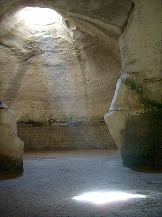
Beit Guvrin-Maresha National Park is a national park in central Israel, containing a large network of caves recognized by UNESCO as a World Heritage Site. The national park includes the remains of the historical towns of Maresha, one of the important towns of Judah during the First Temple Period, and Bayt Jibrin, a depopulated Palestinian town known as Eleutheropolis in the Roman era. However, Maresha and Bayt Jibrin are not part of the UNESCO site, which covers only the cave network.

The Beirut River is a river in Lebanon separating the city of Beirut from its eastern suburbs, primarily Bourj Hammoud and Sin el Fil. The river flows mostly east to west from snow drains and springs on the western slopes of Mount Kneisseh and the southern end of Mount Sannine near the towns of Hammana and Falougha, before curving north and emptying at Beirut's northern Mediterranean coast, east of the Port of Beirut. According to popular legend, St. George slew the dragon in a spot near the mouth of the river.

Sheikh Bureik, locally called Sheikh Abreik or Sheikh Ibreik in recent times, was a Palestinian Arab village located 10 miles (16 km) southeast of Haifa. Situated at an ancient site that shows evidence of habitation as early as the Iron Age, it was known as Beit She'arayim in the Roman and Byzantine periods and became an important center of Jewish learning in the 2nd century, with habitation continuing during the Early Islamic period and limited signs of activity from the Crusader period.
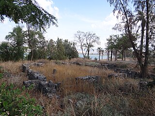
Al-Sinnabra or Sinn en-Nabra, is the Arabic place name for a historic site on the southern shore of the Sea of Galilee in modern-day Israel. The ancient site lay on a spur from the hills that close the southern end of the Sea of Galilee, next to which towards its south being the tell, Khirbet Kerak or Bet Yerah, one of the largest in the Levant, spanning an area of over 50 acres. Bet Yerah was the Hellenistic era twin city of Sennabris, as al-Sinnabra was known in Classical antiquity, and its remains are located at the same tell.
Mazar of Al-Mazar may refer to:
Several calendars have been used in pre-Islamic Arabia. Inscriptions of the ancient South Arabian calendars reveal the use of a number of local calendars. At least some of these South Arabian calendars followed the lunisolar system. For Central Arabia, especially Mecca, there is a lack of epigraphic evidence, but details are found in the writings of Muslim authors of the Abbasid era. Some historians maintain that the pre-Islamic calendar used in Central Arabia was a purely lunar calendar similar to the modern Islamic calendar. Others concur that the pre-Islamic calendar was originally a lunar calendar, but suggest that about 200 years before the Hijra it was transformed into a lunisolar calendar, which had an intercalary month added from time to time to keep the pilgrimage within the season of the year when merchandise was most abundant.

The Mosaic of Reḥob (Hebrew: כתובת רחוב, romanized: k'tovet rechov, also known as the Tel Rehov inscription and the Baraita of the Boundaries, is a late 3rd–6th century CE mosaic discovered in 1973. The mosaic, written in late Mishnaic Hebrew, describes the geography and agricultural rules of the local Jews of the era. It was inlaid in the floor of the foyer or narthex of an ancient synagogue near Tel Rehov, 4.5 kilometres south of Beit She'an and about 6.5 kilometres west of the Jordan River. The mosaic contains the longest written text yet discovered in any Hebrew mosaic in Israel, and also the oldest known Talmudic text.

Khirbet et-Tibbâneh (Arabic: خربة التبانة), sometimes referred to by historical geographers as the Timnah of Judah, is a small ruin situated on a high ridge in the Judaean mountains, in the Sansan Nature Reserve, 622 metres (2,041 ft) above sea level, about 3 kilometers east of Aviezer and ca. 7 kilometers southeast of Bayt Nattif.
Ziyad Jamil Abdel Fattah is a Palestinian politician, writer, journalist and novelist, born in Tulkarm, Palestine. He is one of the leaders of the Fatah movement, founder of the Palestinian News Agency, a member of the Palestinian National Council in the Palestine Liberation Organization for several sessions, and the former president of Federation of Arab News Agencies (FANA), the Palestinian General Authority for Consultations, and the Palestinian National Library. Abdel Fattah was very close to late president Yasser Arafat, and he witnessed all the events on his side. Abdel Fattah has been dubbed "the legend of the Palestinian revolution media."
Oikonyms in Western, Central, South, and Southeast Asia can be grouped according to various components, reflecting common linguistic and cultural histories. Toponymic study is not as extensive as it is for placenames in Europe and Anglophone parts of the world, but the origins of many placenames can be determined with a fair degree of certainty. One complexity to the study when discussing it in English is that the Romanization of names, during British rule and otherwise, from other languages has not been consistent.

Tarim is a historic town situated in Wadi Hadhramaut, Yemen. It is widely acknowledged as the theological, juridical, and academic center of the Hadhramaut Valley. An important center of Islamic learning, it is estimated to contain the highest concentration of descendants of the Islamic Prophet Muhammad known as the Sadah anywhere in the world. The city is distinguished for producing numerous Islamic scholars, including Imam al-Haddad. Additionally, Tarim is also home to Dar al-Mustafa, a well-known educational institution for the study of traditional Islamic Sciences.
| Branches |
| ||||||||
|---|---|---|---|---|---|---|---|---|---|
| Techniques and tools |
| ||||||||
| Institutions | |||||||||
| Education | |||||||||