Goodnight, Kentucky

Last updated

Goodnight
USA Kentucky location map.svg
Red pog.svg
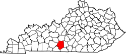
Goodnight
Location within the state of Kentucky
Usa edcp location map.svg
Red pog.svg
Goodnight
Goodnight (the United States)
Coordinates: 37°5′36″N85°52′49″W / 37.09333°N 85.88028°W / 37.09333; -85.88028
Country United States
State Kentucky
County Barren
Elevation
738 ft (225 m)
Time zone UTC-6 (Central (CST))
  Summer (DST) UTC-5 (CST)
GNIS feature ID508113 [1]

Goodnight is an unincorporated community in Barren County, Kentucky, United States. The community was named in honor of Isaac Goodnight, a member of the United States House of Representatives from Kentucky. [2]

Related Research Articles

<span class="mw-page-title-main">Kentucky</span> U.S. state

Kentucky, officially the Commonwealth of Kentucky, is a state in the Southeastern region of the United States and one of the states of the Upper South. Kentucky borders Illinois, Indiana, and Ohio to the north, West Virginia to the northeast, Virginia to the east, Tennessee to the south, and Missouri to the west. Its northern border is defined by the Ohio River. Its capital is Frankfort and its largest city is Louisville. Its population was approximately 4.5 million in 2020.

<span class="mw-page-title-main">Hopkins County, Kentucky</span> County in Kentucky, United States

Hopkins County is a county located in the western part of the U.S. state of Kentucky. As of the 2020 census, the population was 45,423. Its county seat is Madisonville. Hopkins County was created December 9, 1806 from Henderson County. It was named for General Samuel Hopkins, an officer in both the American Revolutionary War and War of 1812, and later a Kentucky legislator and U.S. Congressman.

<span class="mw-page-title-main">Barren County, Kentucky</span> County in Kentucky, United States

Barren County is a county located in the south-central portion of the U.S. state of Kentucky. As of the 2020 census, the population was 44,485. Its county seat is Glasgow. The county was founded on December 20, 1798, from parts of Warren and Green Counties. It was named for the Barrens, meadowlands that cover the northern third, though actually the soil is fertile. Barren County is part of the Glasgow, KY Micropolitan Statistical Area, which is also included in the Bowling Green-Glasgow, KY Combined Statistical Area. In 2007 Barren County was named the "Best Place to Live in Rural America" by Progressive Farmer Magazine.

<span class="mw-page-title-main">Owingsville, Kentucky</span> City in Kentucky, United States

Owingsville is a home rule-class city in Bath County, Kentucky, in the United States. The population was 1,530 during the year 2010 U.S. Census. It is the county seat and is located roughly at the county's center, at the junction of US 60 and Kentucky 36. It is part of the Mount Sterling micropolitan area.

<span class="mw-page-title-main">Harlan, Kentucky</span> City in Kentucky, United States

Harlan is a home rule-class city in and the county seat of Harlan County, Kentucky, United States. The population was 1,745 at the 2010 census, down from 2,081 at the 2000 census.

<span class="mw-page-title-main">Independence, Kentucky</span> City in Kentucky, United States

Independence is a home rule-class city in Kenton County, Kentucky, in the United States. It is one of its county's two seats of government. The population was 24,757 at the time of the 2010 U.S. census, up from 14,982 at the 2000 census. It is the third largest city in Northern Kentucky after Covington and Florence.

<span class="mw-page-title-main">Franklin, Kentucky</span> City in Kentucky, United States

Franklin is a home rule-class city in and the county seat of Simpson County, Kentucky, United States. The county is located on the south central border of the state, and its population was 10,176 at the 2020 census.

A census-designated place (CDP) is a concentration of population defined by the United States Census Bureau for statistical purposes only.

<span class="mw-page-title-main">Oliver Loving</span> Cattle rancher and pioneer of the cattle drive (1812–1867)

Oliver Loving was an American rancher and cattle driver. Together with Charles Goodnight, he developed the Goodnight-Loving Trail. He was mortally wounded by Native Americans while on a cattle drive.

Good Night or Goodnight may refer to:

Commonwealth is a term used by four of the 50 states of the United States in their full official state names. "Commonwealth" is a traditional English term used to describe a political community as having been founded for the common good. The four states – Kentucky, Massachusetts, Pennsylvania, and Virginia – are all in the Eastern United States, and prior to the formation of the United States in 1776 were British colonial possessions. As such, they share a strong influence of English common law in some of their laws and institutions. However, the "commonwealth" appellation has no legal or political significance, and it does not make "commonwealth" states any different from other U.S. states.

Goodnight is a village in southern Polk County, Missouri, United States. Located on Route 215, the community is part of the Springfield, Missouri Metropolitan Statistical Area. The population was 18 at the 2010 census.

<span class="mw-page-title-main">Isaac Goodnight</span> American politician

Isaac Herschel Goodnight was a United States representative from Kentucky.

<span class="mw-page-title-main">Ceratolasmatidae</span> Family of harvestmen/daddy longlegs

The Ceratolasmatidae are a family of harvestmen with eleven described species.

<span class="mw-page-title-main">Blue Heron, Kentucky</span> Coal town in Kentucky, United States

Blue Heron, also known as Mine 18, is a former coal mining community or coal town on the banks of the Big South Fork of the Cumberland River in McCreary County, Kentucky, United States, that has been recreated and is maintained as an interpretive history area in the Big South Fork National River and Recreation Area.

Goodnight is an unincorporated community in Armstrong County, Texas, United States. The community is part of the Amarillo Metropolitan Statistical Area. In 2000, the population was 18.

<span class="mw-page-title-main">Unknown Confederate Dead Monument in Perryville</span> Civil War memorial in Boyle County, Kentucky

The Unknown Confederate Dead Monument in Perryville is located in the vicinity of Perryville, in Boyle County, Kentucky, United States, in the Goodknight Cemetery, a small family cemetery on private land. It is presumed to have been constructed around the year 1928, sixty-six years after the Battle of Perryville on October 8, 1862, in which the Confederate soldiers buried here anonymously died. In total, 532 Confederates died at the battle, but it is unknown how many of this number are buried here.

Meta is an unincorporated community in Pike County, Kentucky. Meta is located at the junction of Kentucky Route 1426 and Kentucky Route 2169 7.7 miles (12.4 km) northeast of Pikeville. The community had a post office from 1896 to 1959.

Piso is an unincorporated community located in Pike County, Kentucky, United States. Their post office has been closed. The community was named by Bud Williamson after viewing an advertisement for medicine in an almanac.

<span class="mw-page-title-main">Goodnight House</span> Historic house in Franklin, Kentucky

The Goodnight House, at 201 S. Main St. in Franklin, Kentucky, was built in 1893. It was listed on the National Register of Historic Places in 1977. Designed by the McDonald Brothers, it is Late Victorian in style. It has also been known as the Judge Isaac Herschel Goodnight & Mrs. Ella Hoy Goodnight House and was home of Isaac Herschel Goodnight, who served three terms in the United States House of Representatives from 1889 to 1895. After that, he returned to his law practice in Franklin, and later became judge of Kentucky's 7th Circuit Court District.

References

  1. U.S. Geological Survey Geographic Names Information System: Goodnight, Kentucky
  2. Rennick, Charles (1984). Kentucky Place Names. Lexington, KY: University Press of Kentucky. p. 119.