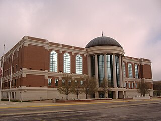
Warren County is a county located in the south central portion of the U.S. state of Kentucky. As of the 2020 census, the population was 134,554, making it the fifth-most populous county in Kentucky. The county seat is Bowling Green. Warren County is now classified as a wet county after voters approved the measure in 2018. The measure became law in January 2019 that allows alcohol to be sold county wide.

Hart County is a county located in the south central portion of the Commonwealth of Kentucky. As of the 2020 census, the population was 19,288. Its county seat is Munfordville, its largest city is Horse Cave. Hart County is a prohibition or dry county.

Edmonson County is a county located in the south central portion of the U.S. state of Kentucky. As of the 2020 census, the population was 12,126. Its county seat and only municipality is Brownsville. The county was formed in 1825 and named for Captain John "Jack" Edmonson (1764–1813), who was killed at the Battle of Frenchtown during the War of 1812. This is a dry county where the sale of alcohol is prohibited. Edmonson County is included in the Bowling Green, Kentucky Metropolitan Statistical Area.

Barren County is a county located in the south-central portion of the U.S. state of Kentucky. As of the 2020 census, the population was 44,485. Its county seat is Glasgow. The county was founded on December 20, 1798, from parts of Warren and Green Counties. It was named for the Barrens, meadowlands that cover the northern third, though actually the soil is fertile. Barren County is part of the Glasgow, KY Micropolitan Statistical Area, which is also included in the Bowling Green-Glasgow, KY Combined Statistical Area. In 2007 Barren County was named the "Best Place to Live in Rural America" by Progressive Farmer Magazine.
Horse Cave is a home rule-class city in Hart County, Kentucky, United States. Randall Curry currently serves as mayor of the city and is assisted by a city council that is composed of six members. As of the 2010 census, the population of Horse Cave was 2,311, making it the most populous community in the county.

Cave City is a home rule-class city in Barren County, Kentucky, in the United States. The population was 2,240 at the 2010 census. It is part of the Glasgow Micropolitan Statistical Area.

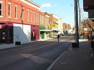
Glasgow is a home rule-class city in Barren County, Kentucky, United States. It is the seat of its county. Glasgow is the principal city of the Glasgow micropolitan area, which comprises Barren and Metcalfe counties. The population was 15,014 at the 2020 U.S. census.

Park City is a home rule-class city in Barren County, Kentucky, United States. The population was 537 at the 2010 census. It has served as the historical entrance to nearby Mammoth Cave National Park and to Diamond Caverns, a privately owned cave attraction. Exit 48 off I-65 is the only direct access exit to the Mammoth Cave National Park.

U.S. Route 31E (US 31E) is the easternmost of two parallel routes for U.S. Highway 31 from Nashville, Tennessee, to Louisville, Kentucky.

Kentucky Route 90 is a major east–west state highway in southern Kentucky. The route is 134.734 miles (216.833 km) long, and it traverses Barren, Metcalfe, Cumberland, Clinton, Wayne, Pulaski, McCreary and Whitley Counties in southern Kentucky. It runs from the KY 70 junction near Interstate 65 in Cave City to US 25W about 8 miles (13 km) from Interstate 75.

Kentucky Route 70 (KY 70) is a long east-east state highway that originates at a junction with U.S. Route 60 (US 60) in Smithland in Livingston County, just east of the Ohio River. The route continues through the counties of Crittenden, Caldwell, Hopkins, Muhlenberg, Butler, Edmonson, Barren, Barren, Metcalfe, Green, Taylor, Casey, Pulaski, Lincoln and back into Pulaski again to terminate at a junction with US 150 near Maretburg in Rockcastle.

Kentucky Route 255 (KY 255) is a 16.977-mile-long (27.322 km) south-north state highway located in south central Kentucky. It provides access to Interstate 65 and Mammoth Cave National park to residents of southern Barren County.
Temple Hill is an unincorporated community in Barren County, Kentucky, in the United States.

Kentucky Route 218 is a 31.113-mile-long (50.072 km) west-east state highway that traverses three counties in south-central Kentucky. It is locally known as LeGrande Highway from Horse Cave to near Shady Grove.
Houchin's Ferry Road is a secondary roadway located in Edmonson County in west-central Kentucky. County road logs list this road as CR-1004 and CR-1005.
Kyrock is a ghost town in Edmonson County in south central Kentucky. The ghost town is located about 2.4 miles (3.9 km) east of Sweeden, or about 5 miles (8.0 km) north-northeast of the county seat of Brownsville. It was once a referred to as a “company town” along the Nolin River during much of the first half of the 20th century, but the industrial town was disincorporated in 1966, about nine years after the closure of the company that created the town.
Griderville is a rural unincorporated community in northern Barren County, Kentucky, United States.
Reedyville is an Unincorporated community in Butler County, Kentucky, United States. The town is supposedly named for the nearby Big Reedy Creek, a tributary of the Green River.
Northtown is an unincorporated community in Hart County, Kentucky, United States. The elevation of Northtown is 837 feet. It appears on the Mammoth Cave U.S. Geological Survey Map and is in the Central Time Zone.


