
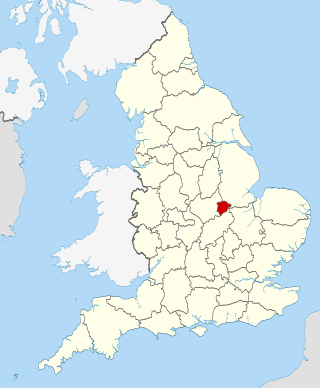
There are over 20,000 Grade II* listed buildings in England. This page is a list of these buildings in the district of North Warwickshire in Warwickshire.
There are over 20,000 Grade II* listed buildings in England. This page is a list of these buildings in the district of North Warwickshire in Warwickshire.
| Name | Location | Type | Completed [note 1] | Date designated | Grid ref. [note 2] Geo-coordinates | Entry number [note 3] | Image |
|---|---|---|---|---|---|---|---|
| Church of St Lawrence | Church End, Ansley, North Warwickshire | Church | Mid to late 12th century | 25 March 1968 | SP2901392637 52°31′51″N1°34′25″W / 52.530834°N 1.573746°W | 1365141 |  |
| Church of St Wilfred | Old Arley, Arley, North Warwickshire | Church | 14th century | 30 March 1988 | SP2832190618 52°30′46″N1°35′03″W / 52.51272°N 1.584118°W | 1034773 | 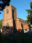 |
| Astley Castle | Astley Castle, Astley, North Warwickshire | Country House | Mid 16th century | 11 November 1952 | SP3116289485 52°30′09″N1°32′33″W / 52.50238°N 1.542363°W | 1365144 |  |
| Stable block at Astley Castle | Astley Castle, Astley, North Warwickshire | Stable | Mid to late 18th century | 11 November 1952 | SP3114789392 52°30′06″N1°32′33″W / 52.501545°N 1.542593°W | 1034777 |  Upload Photo |
| Beech House and attached Railings | Atherstone, North Warwickshire | Row | 1708 | 25 March 1968 | SP3085297896 52°34′41″N1°32′46″W / 52.578009°N 1.546151°W | 1185175 | Upload Photo |
| Church of St Mary | Atherstone, North Warwickshire | Church | 14th century | 25 March 1968 | SP3084497969 52°34′43″N1°32′47″W / 52.578666°N 1.546262°W | 1365164 | 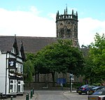 |
| Church of St Nicholas | Austrey, North Warwickshire | Church | Late 13th century | 22 July 1953 | SK2957906282 52°39′12″N1°33′51″W / 52.653466°N 1.564188°W | 1365184 |  |
| Church of St Theobald and Saint Chad | Caldecote, North Warwickshire | Church | Late 13th century | 25 March 1968 | SP3487295124 52°33′10″N1°29′14″W / 52.552848°N 1.487121°W | 1034744 |  |
| Cole Bridge | Coleshill, North Warwickshire | Road Bridge | Mid 16th century | 8 September 1961 | SP1992589513 52°30′11″N1°42′28″W / 52.503156°N 1.707897°W | 1034701 | 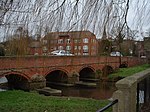 |
| Church of St Mary | Corley, North Warwickshire | Parish Church | Early 12th century | 8 September 1961 | SP3012085113 52°27′47″N1°33′29″W / 52.463136°N 1.558106°W | 1299365 |  |
| Corley Hall and attached Wall and Gatepiers | Corley, North Warwickshire | House | 17th century | 11 November 1952 | SP3046685724 52°28′07″N1°33′11″W / 52.468609°N 1.552958°W | 1034864 | Upload Photo |
| Church of St Nicholas and St Peter | Curdworth, North Warwickshire | Church | Late 12th century | 8 September 1961 | SP1779292811 52°31′58″N1°44′21″W / 52.532878°N 1.739145°W | 1185754 | 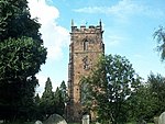 |
| Church of St Mary and All Saints | Fillongley, North Warwickshire | Church | 12th century | 8 September 1961 | SP2808887171 52°28′54″N1°35′16″W / 52.481744°N 1.587841°W | 1034830 | 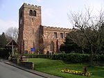 |
| Stone House Farmhouse | Fillongley, North Warwickshire | Farmhouse | 19th century | 23 March 1988 | SP2610587742 52°29′13″N1°37′01″W / 52.486976°N 1.616995°W | 1034866 |  |
| Packington Hall | Packington Park, Great Packington, North Warwickshire | Country House | Late 17th century | 11 November 1952 | SP2227683820 52°27′07″N1°40′25″W / 52.451887°N 1.673642°W | 1116473 | 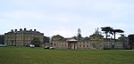 |
| Packington Old Hall with Walls adjoining on East and West Sides, Courtyard Wall adjoining at Rear, and attached Outbuildings | Packington Park, Great Packington, North Warwickshire | House | 1679 | 11 November 1952 | SP2308484616 52°27′32″N1°39′42″W / 52.459009°N 1.661698°W | 1034811 |  |
| Church of All Saints | Grendon, North Warwickshire | Church | 12th century | 25 March 1968 | SK2872000918 52°36′19″N1°34′38″W / 52.605292°N 1.577351°W | 1034716 | 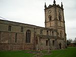 |
| Grendon Bridge (that Part in Grendon Civil Parish) Grendon Bridge (that Part in Polesworth Civil Parish) | Grendon, North Warwickshire | Bridge | 15th century | 23 November 1951 | SK2845000986 52°36′21″N1°34′53″W / 52.605917°N 1.581332°W | 1186247 |  |
| Hartshill Grange | Hartshill, North Warwickshire | House | Early 18th century | 25 November 1969 | SP3299894731 52°32′58″N1°30′53″W / 52.549432°N 1.514798°W | 1034749 | Upload Photo |
| Church of Saint Peter and Saint Paul | Kingsbury, North Warwickshire | Church | 12th century | 22 July 1953 | SP2147696265 52°33′50″N1°41′05″W / 52.563796°N 1.684614°W | 1034683 |  |
| Kingsbury Hall | Kingsbury, North Warwickshire | Manor House | c. 1500 | 22 July 1953 | SP2138896321 52°33′51″N1°41′09″W / 52.564303°N 1.685909°W | 1116550 | 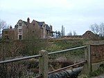 |
| Mancetter Manor and attached Gatepier | Mancetter, North Warwickshire | Double Ended Hall House | Extended | 23 November 1951 | SP3203296623 52°33′59″N1°31′44″W / 52.566498°N 1.528861°W | 1185415 |  |
| Church of St Michael and All Angels | Maxstoke, North Warwickshire | Church | Early 14th century | 8 September 1961 | SP2359286863 52°28′45″N1°39′15″W / 52.479188°N 1.654064°W | 1365128 |  |
| Churchyard Cross 20 Metres South East of Church of St Michael and All Angels | Maxstoke, North Warwickshire | Cross | 14th century | 23 March 1988 | SP2360486850 52°28′45″N1°39′14″W / 52.47907°N 1.653888°W | 1116121 |  |
| Inner Precinct Wall approximately 100 Metres West of Priory Farmhouse | Maxstoke, North Warwickshire | Mill House | 1336 | 8 September 1961 | SP2340286795 52°28′43″N1°39′25″W / 52.478584°N 1.656866°W | 1034821 | Upload Photo |
| Outer Gatehouse and attached Precinct Walls and Barn 200 Metres North of Priory Farmhouse | Maxstoke, North Warwickshire | Precinct Wall | 14th century | 8 September 1961 | SP2345286889 52°28′46″N1°39′22″W / 52.479427°N 1.656123°W | 1365129 |  |
| Precinct Wall, West of Outer Gatehouse | Maxstoke, North Warwickshire | Precinct Wall | Early 14th century | 8 September 1961 | SP2333886904 52°28′46″N1°39′28″W / 52.479567°N 1.6578°W | 1116038 | 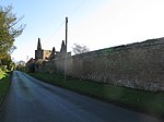 |
| Precinct Wall, East of Outer Gatehouse and Bounding Churchyard of St Michael and All Saints on the West | Maxstoke, North Warwickshire | Precinct Wall | Early 14th century | 8 September 1961 | SP2353886890 52°28′46″N1°39′17″W / 52.479433°N 1.654857°W | 1034823 | 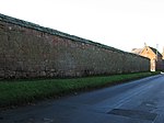 |
| Priory Farmhouse | Maxstoke, North Warwickshire | House | Late 16th century | 11 November 1952 | SP2345086833 52°28′44″N1°39′22″W / 52.478924°N 1.656156°W | 1116105 | 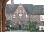 |
| Remains of Tower and Walls of Monastic Church approximately 250 Metres South of Priory Farmhouse | Maxstoke, North Warwickshire | Church | 1336 | 8 September 1961 | SP2344586742 52°28′41″N1°39′22″W / 52.478106°N 1.656236°W | 1320105 | 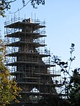 |
| West Wall of Former Infirmary, approximately 150 Metres South of Priory Farmhouse | Maxstoke, North Warwickshire | Augustinian Monastery | Early 14th century | 8 September 1961 | SP2348086776 52°28′42″N1°39′21″W / 52.47841°N 1.655719°W | 1034822 | Upload Photo |
| Merevale Hall | Merevale Park, Merevale, North Warwickshire | Country House | Late 17th century | 25 March 1968 | SP2953697350 52°34′23″N1°33′56″W / 52.573174°N 1.565619°W | 1299654 | 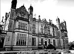 |
| Remains of Merevale Abbey | Merevale, North Warwickshire | Abbey | 1148 | 23 November 1951 | SP2922797783 52°34′37″N1°34′13″W / 52.577083°N 1.57014°W | 1365173 | Upload Photo |
| Stable Block and attached Forecourt Walls, Gatepiers and Gates at Merevale Hall | Merevale Park, Merevale, North Warwickshire | Gate | 1835-42 | 1 November 1959 | SP2953397289 52°34′21″N1°33′56″W / 52.572626°N 1.565669°W | 1185536 | Upload Photo |
| Church of St John the Baptist | Middleton, North Warwickshire | Church | Mid 12th century | 26 January 1989 | SP1768198346 52°34′58″N1°44′26″W / 52.58264°N 1.740488°W | 1034640 |  |
| House approximately 50 Metres North East of Middleton Hall | Middleton Park, Middleton, North Warwickshire | House | c. 1600 | 26 January 1989 | SP1930698162 52°34′51″N1°42′59″W / 52.580931°N 1.716516°W | 1365197 | Upload Photo |
| Middleton Hall | Middleton Park, Middleton, North Warwickshire | Country House | Early 18th century | 26 January 1989 | SP1925498097 52°34′49″N1°43′02″W / 52.580348°N 1.717287°W | 1365196 |  |
| Botts Green Hall | Botts Green, Nether Whitacre, North Warwickshire | Jettied House | 1593 | 11 November 1952 | SP2439692508 52°31′48″N1°38′31″W / 52.5299°N 1.641814°W | 1365198 |  |
| Walls, Towers and Gateway enclosing Whitacre Hall | Nether Whitacre, North Warwickshire | Moat | Early 16th century | 11 November 1952 | SP2413793674 52°32′25″N1°38′44″W / 52.540393°N 1.645547°W | 1365199 | Upload Photo |
| Church of St Mary | Newton Regis, North Warwickshire | Church | Early 13th century | 22 July 1953 | SK2791907468 52°39′51″N1°35′19″W / 52.664215°N 1.588626°W | 1116451 | 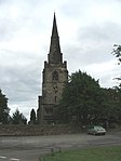 |
| Church of St Leonard | Over Whitacre, North Warwickshire | Church | 1766 | 8 September 1961 | SP2545791028 52°31′00″N1°37′35″W / 52.516546°N 1.626287°W | 1115596 |  |
| Hoar Hall | Over Whitacre, North Warwickshire | House | 1732 | 23 March 1988 | SP2595591954 52°31′29″N1°37′08″W / 52.524848°N 1.618877°W | 1034798 | Upload Photo |
| Abbey Gatehouse | Polesworth, North Warwickshire | Abbey | Late 14th century | 23 November 1951 | SK2629102554 52°37′12″N1°36′47″W / 52.620121°N 1.613087°W | 1262202 |  |
| Church of St Editha | Polesworth, North Warwickshire | Church | 11th century ORIGINS | 25 March 1968 | SK2633202433 52°37′09″N1°36′45″W / 52.619032°N 1.612491°W | 1252564 | 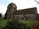 |
| Gate House | Polesworth, North Warwickshire | House | Later | 23 November 1951 | SK2631002562 52°37′13″N1°36′46″W / 52.620192°N 1.612806°W | 1252594 | Upload Photo |
| Pooley Hall, attached Former Chapel and Pooley Hall Farmhouse | Polesworth, North Warwickshire | Farmhouse | 1988 | 23 November 1951 | SK2588502817 52°37′21″N1°37′09″W / 52.622505°N 1.619063°W | 1365179 | 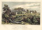 |
| 22 High Street | Polesworth, North Warwickshire | House | Late 16th century | 25 March 1968 | SK2628302553 52°37′12″N1°36′48″W / 52.620113°N 1.613205°W | 1252595 | Upload Photo |
| Church of All Saints | Seckington, North Warwickshire | Church | mid/late 13th century | 22 July 1953 | SK2601807417 52°39′50″N1°37′00″W / 52.66385°N 1.616738°W | 1252599 | 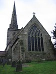 |
| Church of St Cuthbert | Shustoke, North Warwickshire | Church | Late 13th century | 8 September 1961 | SP2429690990 52°30′59″N1°38′36″W / 52.516258°N 1.643398°W | 1320424 | 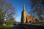 |
| Priory Farmhouse | Shustoke, North Warwickshire | Farmhouse | Late 15th century | 23 March 1988 | SP2271490929 52°30′57″N1°40′00″W / 52.515777°N 1.666715°W | 1320436 |  |
| Shustoke Hall Farmhouse | Shustoke, North Warwickshire | House | 1988 | 23 March 1988 | SP2339390019 52°30′27″N1°39′24″W / 52.507568°N 1.656773°W | 1266022 | Upload Photo |
| Moat, Bridges and Gatepiers at Shustoke Hall Farmhouse | Shustoke, North Warwickshire | Moat | c. 1686 | 11 November 1952 | SP2339390001 52°30′27″N1°39′24″W / 52.507406°N 1.656774°W | 1226189 | Upload Photo |
| Church of St Chad | Wishaw, North Warwickshire | Church | 13th century | 8 September 1961 | SP1767794570 52°32′55″N1°44′27″W / 52.548694°N 1.740747°W | 1034654 | 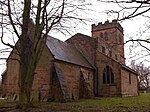 |

There are over 9,000 Grade I listed buildings in England. This page is a list of these buildings in the county of Hertfordshire, organised by district.

There are over 9,000 Grade I listed buildings in England. This page is a list of these buildings in the county of Nottinghamshire, by district.

There are over 9000 Grade I listed buildings in England. This page is a list of these buildings in the county of Staffordshire, by district.

There are over 9,000 Grade I listed buildings in England. This page is a list of these buildings in the county of Warwickshire, by district.

There are 19 Grade I listed buildings in the City of Coventry. In the United Kingdom, a listed building is a building or structure of special historical or architectural importance. These buildings are legally protected from demolition, as well as from any extensions or alterations that would adversely affect the building's character or destroy historic features. Listed buildings in England and Wales are divided into three categories—Grade II buildings are buildings of special interest; Grade II* buildings are Grade II buildings of particular interest; and Grade I buildings, which are those of "exceptional" interest. Only around four per cent of listed buildings are given Grade I status.

There are over 20,000 Grade II* listed buildings in England. This page is a list of the 183 of these buildings in the ceremonial county of the East Riding of Yorkshire.
There are over 20,000 Grade II* listed buildings in England. This page is a list of the 71 of these buildings in the county of Rutland.

There are over 20,000 Grade II* listed buildings in England. This list includes those in South Yorkshire.
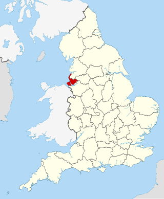
There are over 20,000 Grade II* listed buildings in England. This page is a list of these buildings in the county of Merseyside.
There are over 20,000 Grade II* listed buildings in England. This page is a list of these buildings in the county of Nottinghamshire, by district.
This is a list of Grade II* listed buildings in Lancashire, England.
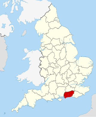
There are over 20,000 Grade II* listed buildings in England. This page is a list of these buildings in the county of West Sussex by district.
There are over 20,000 Grade II* listed buildings in England. This page is a list of these buildings in the district of Nuneaton and Bedworth in Warwickshire.
There are over 20,000 Grade II* listed buildings in England. This page is a list of these buildings in the district of Rugby in Warwickshire.
There are over 20,000 Grade II* listed buildings in England. This page is a list of these buildings in the district of Stratford-on-Avon in Warwickshire.
There are over 20,000 Grade II* listed buildings in England. This page is a list of these buildings in the district of Warwick in Warwickshire.
There are over 20,000 Grade II* listed buildings in England. This page is a list of these buildings in the district of Ashford in Kent.

There are over 20,000 Grade II* listed buildings in England. This page is a list of these buildings in the district of Exeter in Devon.
There are over 20,000 Grade II* listed buildings in England. This page is a list of these buildings in the Borough of Basildon in Essex.

There are over 20,000 Grade II* listed buildings in England. This page is a list of these buildings in the district of Bournemouth in Dorset.