Granvin

Last updated
Granvin herad
Granvin bruk.JPG
View of the village of Granvin
Flag of Granvin.gif
Norway Counties Hordaland Position.svg
NO 1234 Granvin.svg
Granvin within Hordaland
Coordinates: 60°31′37″N06°43′10″E / 60.52694°N 6.71944°E / 60.52694; 6.71944
Country Norway
County Hordaland
District Hardanger
Established1 May 1891
  Preceded by Ulvik Municipality
Disestablished1 Jan 2020
  Succeeded by Voss Municipality
Administrative centre Eide
Government
  Mayor (2011-2019)Ingebjørg Winjum (V)
Area
 (upon dissolution)
  Total211.28 km2 (81.58 sq mi)
  Land203.86 km2 (78.71 sq mi)
  Water7.42 km2 (2.86 sq mi)  3.5%
  Rank#326 in Norway
Population
 (2019)
  Total933
  Rank#403 in Norway
  Density4.6/km2 (12/sq mi)
  Change (10 years)
Decrease2.svg −4.5%
Demonym Gravensar [1]
Official language
[2]
   Norwegian form Nynorsk
Time zone UTC+01:00 (CET)
  Summer (DST) UTC+02:00 (CEST)
ISO 3166 code NO-1234

Granvin is a former municipality in the old Hordaland county, Norway. The municipality existed from 1891 until its dissolution in 2020 when it merged with Voss Municipality. The municipality was located in the traditional district of Hardanger. The administrative centre of Granvin was the village of Eide, which is also called "Granvin". About half of the residents of the municipality lived in the municipal centre. The rest lived in the rural valley areas surrounding the Granvin Fjord or the lake Granvinsvatnet in the central part of the municipality.

Contents

Prior to its dissolution in 2020, the 211-square-kilometre (81 sq mi) municipality is the 326th largest by area out of the 422 municipalities in Norway. Granvin is the 403rd most populous municipality in Norway with a population of 933. The municipality's population density is 4.6 inhabitants per square kilometre (12/sq mi) and its population has decreased by 4.5% over the last decade. [3]

General information

View of a small road in Granvin Sykler forbi Espeland pa veg til Ulvik.jpg
View of a small road in Granvin
Granvin Church Granvin kyrkje 01.JPG
Granvin Church

The parish of Graven was established as a municipality on 1 January 1838 (see formannskapsdistrikt law). This new municipality was very large and it included two annexes to the parish: Ulvik and Eidfjord. On 1 January 1859, "Ulvik" became the main parish, so that Granvin and Eidfjord became annexes to Ulvik, and the name of municipality was changed accordingly. [4]

On 1 May 1891, the municipality of Ulvik was divided into three parts by creating two new municipalities. The western annex (population: 1,331) became the new municipality of Granvin and the southeastern annex (population: 1,018) became the new municipality of Eidfjord. On 1 January 1964, the Lussand-Kvanndal area of Kinsarvik municipality (population: 72) was transferred to Granvin. [4]

On 1 January 2020, the neighboring municipalities of Granvin and Voss were merged into a new large municipality called Voss. [5]

Name

The municipality (originally the parish) is named after the old Granvin farm (Old Norse : Grǫnvin) since the first Granvin Church was built there. The first element is grǫn which means "spruce". The last element is vin which means "meadow" or "pasture". The area is one of the few places in Western Norway that has spruce forests. The name of the parish was spelled as "Graven" before 1858. It was then spelled as "Granvin" from 1858 until 1891. When it became a separate municipality in 1891, the old spelling of "Graven" was used again briefly until 1898. Since 1898 the spelling of "Granvin" has been used. [6]

Coat of arms

The coat of arms was granted on 13 May 1988 and it was in use until 1 January 2020 when the municipality was dissolved. The official blazon is "Vert, a fiddle Or in bend sinister" (Norwegian : På grøn grunn ei gul fele, skråstilt venstre-høgre). This means the arms have a green field (background) and the charge is a diagonal hardanger fiddle (Hardingfele), a type of Norwegian folk instrument. The fiddle has a tincture of Or which means it is commonly colored yellow, but if it is made out of metal, then gold is used. The design was chosen to symbolize the rich folk-music traditions in the Hardanger region and it also symbolizes an active and creative community. The fiddle is a simplified representation of the richly decorated Hardanger fiddles. This fiddle, used to play folk dance music, has two sets or layers of four strings and has a very characteristic sound. The lower set of sympathetic strings is not directly touched by the fiddler, but they vibrate when the other strings are played. The arms were designed by Øyvind Kvamme. The municipal flag has the same design as the coat of arms. [7] [8] [9]

Churches

The Church of Norway had one parish (sokn) within the municipality of Granvin. It is part of the Hardanger og Voss prosti (deanery) in the Diocese of Bjørgvin.

Churches in Granvin
Parish (sokn)Church nameLocation of the churchYear built
Granvin Granvin Church Granvin1726

Geography

View of the Skjervefossen Skjervefossen.jpg
View of the Skjervefossen

The municipality was situated along both sides of the Granvin Fjord (a small arm off of the main Hardangerfjorden) and the valley extending inland from the end of the fjord, in the region of Hardanger. The large lake Granvinsvatnet lies right in the center of the valley, just north of the village of Eide. On both sides of the fjord and valley, there are high mountains. Espeland Falls is located in the Espelandsdalen valley near the border with Ulvik. The Skjervefossen waterfall is also located in Granvin.

Transportation

Norwegian National Road 13 entered Granvin via the Tunsberg Tunnel which runs through the high mountains to the northwest. The highway then ran through Granvin before entering the Vallavik Tunnel which runs through the high mountains to the southeast. The Vallavik Tunnel connects up with the Hardanger Bridge in Ulvik which crosses the Hardangerfjorden. A car ferry service connects Kvanndal (in southwest Granvin) with the villages of Utne and Kinsarvik (in Ullensvang municipality) on the south side of the Hardangerfjord. From 1935 to 1988, Hardanger railway line ran between Granvin and Vossevangen. The line was closed in 1988 and the rails were later removed.

History

In April 1940, during the German invasion of Norway during World War II, there was some fighting between German and Norwegian forces in Granvin. German forces landed in the village of Granvin on 25 April as part of their pincer movement towards the Norwegian military camps at Vossevangen. There was fighting at Skjervefossen for most of that day, until the Norwegian forces retreated late at night to avoid encirclement. Four Norwegian soldiers and at least 30 German soldiers fell in the fighting. [10]

Population

Historical population
YearPop.±% p.a.
18911,331    
19001,276−0.47%
19101,213−0.51%
19201,070−1.25%
19301,159+0.80%
YearPop.±% p.a.
19461,190+0.17%
19511,158−0.54%
19601,102−0.55%
19701,039−0.59%
1980996−0.42%
YearPop.±% p.a.
19901,036+0.39%
20001,044+0.08%
2010947−0.97%
2019937−0.12%
Source: Statistics Norway [11] [12] and Norwegian Historical Data Centre [13]

Upon the dissolution of the municipality, the population of Granvin had been dropping since World War II. In 1951, the population was 1,158. Since then, it has dropped by 21.3% to 911 in 2014. This situation is common in many smaller, rural municipalities in Norway. [14]

Government

While it existed, this municipality was responsible for primary education (through 10th grade), outpatient health services, senior citizen services, unemployment, social services, zoning, economic development, and municipal roads. During its existence, this municipality was governed by a municipal council of directly elected representatives. The mayor was indirectly elected by a vote of the municipal council. [15]

Municipal council

The municipal council (Heradsstyre) of Granvin was made up of 13 representatives that are elected to four year terms. The party breakdown of the council is as follows:

Granvin heradsstyre 20162019 [16]   
Party Name (in Nynorsk)Number of
representatives
  Labour Party (Arbeidarpartiet)2
  Conservative Party (Høgre)2
  Centre Party (Senterpartiet)5
  Socialist Left Party (Sosialistisk Venstreparti)1
  Liberal Party (Venstre)3
Total number of members:13
Granvin heradsstyre 20122015 [17]   
Party Name (in Nynorsk)Number of
representatives
  Conservative Party (Høgre)3
  Centre Party (Senterpartiet)4
  Socialist Left Party (Sosialistisk Venstreparti)1
  Liberal Party (Venstre)5
Total number of members:13
Granvin heradsstyre 20082011 [16]   
Party Name (in Nynorsk)Number of
representatives
  Labour Party (Arbeidarpartiet)6
  Conservative Party (Høgre)2
  Centre Party (Senterpartiet)4
  Liberal Party (Venstre)1
Total number of members:13
Granvin heradsstyre 20042007 [16]   
Party Name (in Nynorsk)Number of
representatives
  Labour Party (Arbeidarpartiet)3
  Conservative Party (Høgre)1
  Centre Party (Senterpartiet)5
  Socialist Left Party (Sosialistisk Venstreparti)2
  Liberal Party (Venstre)2
Total number of members:13
Granvin heradsstyre 20002003 [16]   
Party Name (in Nynorsk)Number of
representatives
  Labour Party (Arbeidarpartiet)2
  Conservative Party (Høgre)2
  Centre Party (Senterpartiet)6
  Socialist Left Party (Sosialistisk Venstreparti)1
  Liberal Party (Venstre)2
Total number of members:13
Granvin heradsstyre 19961999 [18]   
Party Name (in Nynorsk)Number of
representatives
  Labour Party (Arbeidarpartiet)2
  Conservative Party (Høgre)2
  Centre Party (Senterpartiet)6
  Socialist Left Party (Sosialistisk Venstreparti)1
  Liberal Party (Venstre)2
Total number of members:13
Granvin heradsstyre 19921995 [19]   
Party Name (in Nynorsk)Number of
representatives
  Labour Party (Arbeidarpartiet)2
  Conservative Party (Høgre)2
  Centre Party (Senterpartiet)6
  Socialist Left Party (Sosialistisk Venstreparti)1
  Liberal Party (Venstre)2
Total number of members:13
Granvin heradsstyre 19881991 [20]   
Party Name (in Nynorsk)Number of
representatives
  Labour Party (Arbeidarpartiet)3
  Conservative Party (Høgre)2
  Centre Party (Senterpartiet)6
  Liberal Party (Venstre)2
Total number of members:13
Granvin heradsstyre 19841987 [21]   
Party Name (in Nynorsk)Number of
representatives
  Labour Party (Arbeidarpartiet)3
  Conservative Party (Høgre)2
  Centre Party (Senterpartiet)6
 Joint list of the Liberal Party (Venstre) and Christian Democratic Party (Kristelig Folkeparti)2
Total number of members:13
Granvin heradsstyre 19801983 [22]   
Party Name (in Nynorsk)Number of
representatives
  Labour Party (Arbeidarpartiet)3
  Conservative Party (Høgre)2
  Centre Party (Senterpartiet)7
 Joint list of the Liberal Party (Venstre) and Christian Democratic Party (Kristelig Folkeparti)1
Total number of members:13
Granvin heradsstyre 19761979 [23]   
Party Name (in Nynorsk)Number of
representatives
  Labour Party (Arbeidarpartiet)4
  Centre Party (Senterpartiet)7
  Local list for Granvin (Bygdelista for Granvin)2
Total number of members:13
Granvin heradsstyre 19721975 [24]   
Party Name (in Nynorsk)Number of
representatives
  Labour Party (Arbeidarpartiet)4
  Centre Party (Senterpartiet)7
  Local List(s) (Lokale lister)2
Total number of members:13
Granvin heradsstyre 19681971 [25]   
Party Name (in Nynorsk)Number of
representatives
  Labour Party (Arbeidarpartiet)4
  Centre Party (Senterpartiet)6
  Liberal Party (Venstre)3
Total number of members:13
Granvin heradsstyre 19641967 [26]   
Party Name (in Nynorsk)Number of
representatives
  Labour Party (Arbeidarpartiet)3
  Centre Party (Senterpartiet)7
  Liberal Party (Venstre)3
Total number of members:13
Granvin heradsstyre 19601963 [27]   
Party Name (in Nynorsk)Number of
representatives
  Labour Party (Arbeidarpartiet)3
  Centre Party (Senterpartiet)7
  Liberal Party (Venstre)3
Total number of members:13
Granvin heradsstyre 19561959 [28]   
Party Name (in Nynorsk)Number of
representatives
  Labour Party (Arbeidarpartiet)3
  Farmers' Party (Bondepartiet)8
  Liberal Party (Venstre)1
  Joint List(s) of Non-Socialist Parties (Borgarlege Felleslister)1
Total number of members:13
Granvin heradsstyre 19521955 [29]   
Party Name (in Nynorsk)Number of
representatives
  Labour Party (Arbeidarpartiet)3
  Joint List(s) of Non-Socialist Parties (Borgarlege Felleslister)9
Total number of members:12
Granvin heradsstyre 19481951 [30]   
Party Name (in Nynorsk)Number of
representatives
  Local List(s) (Lokale lister)12
Total number of members:12
Granvin heradsstyre 19451947 [31]   
Party Name (in Nynorsk)Number of
representatives
  Local List(s) (Lokale lister)12
Total number of members:12
Granvin heradsstyre 19381941* [32]   
Party Name (in Nynorsk)Number of
representatives
  Labour Party (Arbeidarpartiet)1
  Joint List(s) of Non-Socialist Parties (Borgarlege Felleslister)11
Total number of members:12
Note: Due to the German occupation of Norway during World War II, no elections were held for new municipal councils until after the war ended in 1945.

Mayors

The mayors (Nynorsk : ordførar) of Granvin (incomplete list):

  • 1891-1892: Hans Saakvitne (V)
  • 1968-1972: Torbjørn Seim
  • 1996-2007: Olav Seim (Sp)
  • 2007-2011: Jan Ivar Rødland (Ap)
  • 2011-2019: Ingebjørg Winjum (V)

Notable people

Granvin is a major setting in Moe Cidaly's short story "Summer Episode". [33]

See also

Related Research Articles

<span class="mw-page-title-main">Sokndal</span> Municipality in Rogaland, Norway

Sokndal is the southernmost municipality in Rogaland county, Norway. It is located in the traditional district of Dalane. The administrative centre of the municipality is the village of Hauge. Other villages in Sokndal include Li, Rekefjord, Sogndalsstranda, and Åna-Sira.

<span class="mw-page-title-main">Fitjar</span> Municipality in Vestland, Norway

Fitjar is a municipality in Vestland county, Norway. The municipality is located in the traditional district of Sunnhordland. Fitjar municipality includes the northern part of the island of Stord and the hundreds of surrounding islands, mostly to the northwest of the main island. The administrative centre of the municipality is the village of Fitjar.

<span class="mw-page-title-main">Kvinnherad</span> Municipality in Vestland, Norway

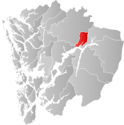
Kvinnherad is a municipality in Vestland county, Norway. It is located in the traditional district of Sunnhordland, along the Hardangerfjorden. The municipality was the 5th in size in former Hordaland county.

<span class="mw-page-title-main">Jondal</span> Former municipality in Hordaland, Norway

Jondal is a former municipality in the old Hordaland county, Norway. The 247-square-kilometre (95 sq mi) municipality existed from 1863 until its dissolution in 2020 when it became part of Ullensvang Municipality in Vestland county. It was located on the Folgefonna peninsula in the Hardanger district, on the eastern shore of the Hardangerfjorden. The administrative centre of the municipality was the village of Jondal. Other villages in Jondal include Herand, Kysnesstranda, and Torsnes.

<span class="mw-page-title-main">Odda</span> Former municipality in Hordaland, Norway

Odda is a former municipality in the old Hordaland county, Norway. The municipality existed from 1913 until its dissolution in 2020 when it was merged into Ullensvang Municipality in Vestland county. It was located in southeastern Hordaland county, surrounding the southern end of the Sørfjorden. The administrative centre was the town of Odda, which was also the main commercial and economic centre of the entire Hardanger region. Other villages in the municipality included Botnen, Eitrheim, Håra, Røldal, Seljestad, Skare, and Tyssedal.

<span class="mw-page-title-main">Ullensvang</span> Municipality in Vestland, Norway

Ullensvang is a municipality in Vestland county, Norway. It is located in the traditional district of Hardanger. The administrative centre is the town of Odda. Some of the notable villages in the municipality include Lofthus, Utne, Vikebygd, Alsåker, Botnen, Eitrheim, Håra, Røldal, Seljestad, Skare, Tyssedal, Jondal, Herand, Kysnesstranda, and Torsnes.

<span class="mw-page-title-main">Eidfjord</span> Municipality in Vestland, Norway

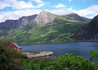
Eidfjord is a municipality in Vestland county, Norway. The municipality is located in the traditional district of Hardanger. The administrative centre of the municipality is the village of Eidfjord, where the majority of the municipal population lives. The other major population centre in the municipality is the village of Øvre Eidfjord.

<span class="mw-page-title-main">Ulvik</span> Municipality in Vestland, Norway

Ulvik is a municipality in Vestland county, Norway. The municipality stretches from the Hardangerfjord to the mountains that reach 1,800 metres (5,900 ft) above sea level. The administrative centre of the municipality is the village of Ulvik. The villages of Osa and Finse are also located in Ulvik municipality.

<span class="mw-page-title-main">Voss</span> Municipality in Vestland, Norway

Voss is a municipality and a traditional district in Vestland county, Norway. The administrative center of the municipality is the village of Vossevangen. Other villages include Bolstadøyri, Borstrondi, Evanger, Kvitheim, Mjølfjell, Oppheim, Stalheim, and Vinje.

<span class="mw-page-title-main">Kvam</span> Municipality in Vestland, Norway

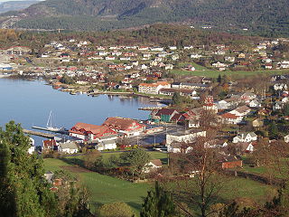
Kvam is a municipality in Vestland county, Norway. The municipality is located along the Hardangerfjorden in the traditional district of Hardanger. The administrative centre of the municipality is the village of Norheimsund. Other larger settlements in the municipality include Øystese, Bru, Ålvik, Tørvikbygd, Omastranda, and Mundheim. Historically, the municipality was named Vikør.

<span class="mw-page-title-main">Fusa</span> Former municipality in Hordaland, Norway

Fusa is a former municipality in the old Hordaland county, Norway. It existed from 1856 until its dissolution in 2020. It was located east of the city of Bergen in the Midhordland region. The administrative centre of the municipality was the village of Eikelandsosen. Other villages in the municipality include Fusa, Holdhus, Holmefjord, Vinnes, Strandvik, and Sundvord. The Frank Mohn company's Fusa marine division is headquartered here, with almost 500 employees. On 1 January 2020, the municipality became part of the new Bjørnafjorden Municipality in Vestland county.

<span class="mw-page-title-main">Bø, Telemark</span> Former municipality in Norway

is a former municipality in Telemark county, Norway. It was part of the traditional region of Midt-Telemark, but was historically regarded as part of Grenland. The 263-square-kilometre (102 sq mi) municipality existed from 1838 until its dissolution in 2020. The area is now part of Midt-Telemark Municipality. The administrative centre was the village of Bø i Telemark. Other villages in the municipality included Folkestad and Nordbøåsane.

<span class="mw-page-title-main">Vanylven</span> Municipality in Møre og Romsdal, Norway

Vanylven is a municipality in Møre og Romsdal county, Norway. It is part of the Sunnmøre region. The administrative centre is the village of Fiskåbygd. Other villages in the municipality include Åheim, Åram, Rovdane, Eidså, Slagnes, and Myklebost.

<span class="mw-page-title-main">Ørsta</span> Municipality in Møre og Romsdal, Norway

is a municipality in Møre og Romsdal county, Norway. It is part of the Sunnmøre region of Western Norway. The administrative centre of the municipality is the village of Ørsta. Other villages in the municipality include Hovdebygda, Flåskjer, Liadal, Urke, Barstadvik, Åmdalen, Follestaddalen, Nordre Vartdal, Vartdal, Sæbø, Sætre, Store-Standal, and Ytre Standal.

<span class="mw-page-title-main">Gjemnes</span> Municipality in Møre og Romsdal, Norway

Gjemnes is a municipality in Møre og Romsdal county, Norway on the Romsdal peninsula. It is part of the Nordmøre region. The administrative centre is the village of Batnfjordsøra, which lies along the Batnfjorden and it is a former steamship landing place. Other villages in Gjemnes include Torvikbukt, Flemma, Angvika, Gjemnes, Øre, and Osmarka.

<span class="mw-page-title-main">Vevelstad</span> Municipality in Nordland, Norway

Vevelstad is a municipality in Nordland county, Norway. It is part of the Helgeland traditional region. The administrative centre of the municipality is the village of Forvika.

<span class="mw-page-title-main">Leirfjord</span> Municipality in Nordland, Norway

Leirfjord is a municipality in Nordland county, Norway. It is part of the Helgeland traditional region. The administrative centre of the municipality is the village of Leland. Other villages in Leirfjord include Bardalssjøen and Sundøy. The large Helgeland Bridge is partly located in the municipality, connecting it to Alstahaug Municipality and the town of Sandnessjøen.

<span class="mw-page-title-main">Lavangen</span> Municipality in Troms og Finnmark, Norway

Lavangen is a municipality in Troms og Finnmark county, Norway. The administrative centre of the municipality is the village of Tennevoll. Other villages in Lavangen include Fossbakken and Spansdalen and Kjeiprød, Røkenes, Låternes, Tennevoll, Hesjevika, Soløy, and Å.

<span class="mw-page-title-main">Salangen</span> Municipality in Troms og Finnmark, Norway

Salangen is a municipality in Troms og Finnmark county, Norway. The administrative centre of the municipality is the village of Sjøvegan, where most of the people in the municipality live. Other villages include Elvenes, Laberg, and Seljeskog.

<span class="mw-page-title-main">Kvænangen</span> Municipality in Troms og Finnmark, Norway

Kvænangen is a municipality in Troms og Finnmark county, Norway. The administrative centre of the municipality is the village of Burfjord. The European route E6 highway goes through the municipality and over the Sørstraumen Bridge, and many people stop at the Kvænangsfjellet pass to view the scenery of the Kvænangen fjord.

References

  1. "Navn på steder og personer: Innbyggjarnamn" (in Norwegian). Språkrådet.
  2. "Forskrift om målvedtak i kommunar og fylkeskommunar" (in Norwegian). Lovdata.no.
  3. Statistisk sentralbyrå (2017). "Table: 06913: Population 1 January and population changes during the calendar year (M)" (in Norwegian). Retrieved 24 October 2017.
  4. 1 2 Jukvam, Dag (1999). Historisk oversikt over endringer i kommune- og fylkesinndelingen (PDF) (in Norwegian). Statistisk sentralbyrå. ISBN   9788253746845.
  5. "Ein Ny Kommune" (in Norwegian). Retrieved 24 October 2017.
  6. Rygh, Oluf (1910). Norske gaardnavne: Søndre Bergenhus amt (in Norwegian) (11 ed.). Kristiania, Norge: W. C. Fabritius & sønners bogtrikkeri. pp. 484–486.
  7. "Civic heraldry of Norway - Norske Kommunevåpen". Heraldry of the World. Retrieved 22 June 2023.
  8. "Granvin, Hordaland". Flags of the World. Retrieved 22 June 2023.
  9. "Godkjenning av våpen og flagg". Lovdata.no (in Norwegian). Norges kommunal- og arbeidsdepartementet. 13 May 1988. Retrieved 22 June 2023.
  10. Hansteen, Wilhelm (1971). Operasjonene til lands på Vestlandet og i Hallingdal og Numedal (in Norwegian). Oslo. pp. 170–183.{{cite book}}: CS1 maint: location missing publisher (link)
  11. Statistisk sentralbyrå. "Table: 06913: Population 1 January and population changes during the calendar year (M)" (in Norwegian).
  12. Statistisk sentralbyrå. "Folketelling 1960" (PDF) (in Norwegian).
  13. Universitetet i Tromsø – Norges arktiske universitet. "Censuses in the Norwegian Historical Data Archive (NHDC)".
  14. "Population changes in municipalities 1951-2014. Granvin" (in Norwegian). Statistics Norway. Retrieved 22 May 2014.
  15. Hansen, Tore; Vabo, Signy Irene, eds. (20 September 2022). "kommunestyre". Store norske leksikon (in Norwegian). Kunnskapsforlaget . Retrieved 1 January 2023.
  16. 1 2 3 4 "Table: 04813: Members of the local councils, by party/electoral list at the Municipal Council election (M)" (in Norwegian). Statistics Norway.
  17. "Tall for Norge: Kommunestyrevalg 2011 - Hordaland". Valg Direktoratet. Retrieved 2 February 2020.
  18. "Kommunestyrevalget 1995" (PDF) (in Norwegian). Oslo-Kongsvinger: Statistisk sentralbyrå. 1996. Retrieved 14 May 2020.
  19. "Kommunestyrevalget 1991" (PDF) (in Norwegian). Oslo-Kongsvinger: Statistisk sentralbyrå. 1993. Retrieved 14 May 2020.
  20. "Kommunestyrevalget 1987" (PDF) (in Norwegian). Oslo-Kongsvinger: Statistisk sentralbyrå. 1988. Retrieved 14 May 2020.
  21. "Kommunestyrevalget 1983" (PDF) (in Norwegian). Oslo-Kongsvinger: Statistisk sentralbyrå. 1984. Retrieved 14 May 2020.
  22. "Kommunestyrevalget 1979" (PDF) (in Norwegian). Oslo: Statistisk sentralbyrå. 1979. Retrieved 14 May 2020.
  23. "Kommunevalgene 1975" (PDF) (in Norwegian). Oslo: Statistisk sentralbyrå. 1977. Retrieved 14 May 2020.
  24. "Kommunevalgene 1972" (PDF) (in Norwegian). Oslo: Statistisk sentralbyrå. 1973. Retrieved 14 May 2020.
  25. "Kommunevalgene 1967" (PDF) (in Norwegian). Oslo: Statistisk sentralbyrå. 1967. Retrieved 14 May 2020.
  26. "Kommunevalgene 1963" (PDF) (in Norwegian). Oslo: Statistisk sentralbyrå. 1964. Retrieved 14 May 2020.
  27. "Kommunevalgene og Ordførervalgene 1959" (PDF) (in Norwegian). Oslo: Statistisk sentralbyrå. 1960. Retrieved 14 May 2020.
  28. "Kommunevalgene og Ordførervalgene 1955" (PDF) (in Norwegian). Oslo: Statistisk sentralbyrå. 1957. Retrieved 14 May 2020.
  29. "Kommunevalgene og Ordførervalgene 1951" (PDF) (in Norwegian). Oslo: Statistisk sentralbyrå. 1952. Retrieved 14 May 2020.
  30. "Kommunevalgene og Ordførervalgene 1947" (PDF) (in Norwegian). Oslo: Statistisk sentralbyrå. 1948. Retrieved 14 May 2020.
  31. "Kommunevalgene og Ordførervalgene 1945" (PDF) (in Norwegian). Oslo: Statistisk sentralbyrå. 1947. Retrieved 14 May 2020.
  32. "Kommunevalgene og Ordførervalgene 1937" (PDF) (in Norwegian). Oslo: Statistisk sentralbyrå. 1938. Retrieved 14 May 2020.
  33. "Summer Episode". moecidaly.com. 2016. Archived from the original on 27 September 2016.