
Tuolumne Meadows is a gentle, dome-studded, sub-alpine meadow area along the Tuolumne River in the eastern section of Yosemite National Park in the United States. Its approximate location is 37°52.5′N119°21′W. Its approximate elevation is 8,619 feet (2,627 m). The term Tuolumne Meadows is also often used to describe a large portion of the Yosemite high country around the meadows, especially in context of rock climbing.

The Historic Columbia River Highway is an approximately 75-mile-long (121 km) scenic highway in the U.S. state of Oregon between Troutdale and The Dalles, built through the Columbia River Gorge between 1913 and 1922. As the first planned scenic roadway in the United States, it has been recognized in numerous ways, including being listed on the National Register of Historic Places, being designated as a National Historic Landmark by the U.S. Secretary of the Interior, being designated as a National Historic Civil Engineering Landmark by the American Society of Civil Engineers, and being considered a "destination unto itself" as an All-American Road by the U.S. Secretary of Transportation. The historic roadway was bypassed by the present Columbia River Highway No. 2 from the 1930s to the 1950s, leaving behind the old two-lane road. The road is now mostly owned and maintained by the state through the Oregon Department of Transportation as the Historic Columbia River Highway No. 100 or the Oregon Parks and Recreation Department as the Historic Columbia River Highway State Trail.

Tioga Pass is a mountain pass in the Sierra Nevada mountain range of California. State Route 120 runs through it, and serves as the eastern entry point for Yosemite National Park, at the Tioga Pass Entrance Station. It is the highest elevation highway pass in California and in the Sierra Nevada at an elevation of 9,945 ft (3,031 m). Mount Dana is to the east of the pass, and Gaylor Peak to the west.

Walker Pass is a mountain pass by Lake Isabella in the southern Sierra Nevada. It is located in northeastern Kern County, approximately 53 mi (85 km) ENE of Bakersfield and 10 mi (16 km) WNW of Ridgecrest. The pass provides a route between the Kern River Valley and San Joaquin Valley on the west, and the Mojave Desert on the east.

State Route 120 is a state highway in the central part of California, connecting the San Joaquin Valley with the Sierra Nevada, Yosemite National Park, and the Mono Lake area. Its western terminus is at Interstate 5 in Lathrop, and its eastern terminus at U.S. Route 6 in Benton. While the route is signed as a contiguous route through Yosemite, the portion inside the park is federally maintained and is not included in the state route logs. The portion at Tioga Pass at Yosemite's eastern boundary is the highest paved through road in the California State Route system. This part is not maintained in the winter and is usually closed during the winter season.

State Route 49 is a north–south state highway in the U.S. state of California that passes through many historic mining communities of the 1849 California gold rush and it is known as the Golden Chain Highway. The highway's creation was lobbied by the Mother Lode Highway Association, a group of locals and historians seeking a single highway to connect many relevant locations along the Gold Rush to honor the 49ers. One of the bridges along SR 49 is named for the leader of the association, Archie Stevenot.

Tenaya Lake is an alpine lake in Yosemite National Park, located between Yosemite Valley and Tuolumne Meadows. The surface of Tenaya Lake has an elevation of 8,150 feet (2,484 m). The lake basin was formed by glacial action, which left a backdrop of light granite rocks, whose beauty was known to the Native Americans. Today, Tenaya Lake is easily accessible by State Route 120 and is a popular lake for water activities.

State Route 88 (SR 88), also known as the Carson Pass Highway, is a state highway in the U.S. state of California. It travels in an east–west direction from Stockton, in the San Joaquin Valley, to the Nevada state line, where it becomes Nevada State Route 88, eventually terminating at U.S. Route 395 (US 395). The highway is so named as it crests the Sierra Nevada at Carson Pass. The highway corridor predates the era of the automobile; the path over Carson pass was previously used for the California Trail and the Mormon Emigrant Trail. The mountainous portion of the route is included in the State Scenic Highway System.

Mineral King is a subalpine glacial valley located in the southern part of Sequoia National Park, in the U.S. state of California. The valley lies at the headwaters of the East Fork of the Kaweah River, which rises at the eastern part of the valley and flows northwest. Accessed by a long and narrow winding road, the valley is mostly popular with backpackers and hikers.

Sonora Pass is a mountain pass in the Sierra Nevada in California. It is the second-highest pass with a road in California and in the Sierra Nevada. It is 321 feet (98 m) lower than Tioga Pass to the south. State Route 108 traverses the pass, as does the Pacific Crest Trail.

The Bridgeport Covered Bridge is located in Bridgeport, Nevada County, California, southwest of French Corral and north of Lake Wildwood. It is used as a pedestrian crossing over the South Yuba River. The bridge was built in 1862 by David John Wood. Its lumber came from Plum Valley in Sierra County, California. The bridge was closed to vehicular traffic in 1972 and pedestrian traffic in 2011 due to deferred maintenance and "structural problems".
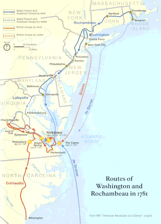
The Washington–Rochambeau Revolutionary Route is a 680-mile (1,090 km) series of roads used in 1781 by the Continental Army under the command of George Washington and the Expédition Particulière under the command of Jean-Baptiste de Rochambeau during their 14-week march from Newport, Rhode Island, to Yorktown, Virginia. Some 4,000 French and 3,000 American soldiers began the march.

The Old Santa Susana Stage Road, or Santa Susana Wagon Road, is a route taken by early travelers between the San Fernando Valley and Simi Valley near Chatsworth, California, via the Santa Susana Pass. The main route climbs through what is now the Santa Susana Pass State Historic Park, with a branch in Chatsworth Park South.
Foote's Crossing Road originates in North Columbia, California and winds through the Tahoe National Forest to connect with the community of Alleghany, California. It is a Registered Historic Place.

The Great Sierra Mine Historic Site preserves the site of the largest mining operation in what would become Yosemite National Park. The mine was located on Tioga Hill on the crest and eastern slope of the Sierra Nevada, one of several claims intended to work the Sheepherder silver lode. The Sheepherder lode was discovered in 1860, and rediscovered by shepherd Thomas Brusky, Jr., who staked a number of claims in the area. In 1881 all of the claims were bought out by the Great Sierra Consolidated Silver Mining Company and established the company town of Dana. Due to the 11,000 foot altitude the town was soon relocated to the bottom of the hill at Bennettville.

The Tioga Pass Entrance Station is the primary entrance for travelers entering Yosemite National Park from the east on the Tioga Pass Road. Open only during the summer months, the entrance station consists of two historical buildings, a ranger station and a comfort station, built in 1931 and 1934 respectively. Both are rustic stone structures with peeled log roof structures, and are examples of the National Park Service rustic style employed at the time by the National Park Service. Two log gate structures that had been removed since the site's original construction were rebuilt in 1999; the stone piers that supported them remain. The use of stone at Tioga Pass set a precedent for the extensive employment of stone construction in other park buildings in the Yosemite high country. Civilian Conservation Corps workers assisted in the entrance station's construction.
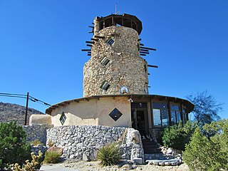
The Desert View Tower is located on Interstate 8, in Boulder Park, in western Imperial County, Southern California. It is also adjacent to remaining sections of Old U.S. Route 80. It is at 3,000 feet (910 m) in elevation, in the In-Ko-Pah Mountains.

Medlicott Dome is a prominent granite dome in Yosemite high country. It is located on the southeast side of Tioga Road, between Mariolumne Dome and Dozier Dome, near Pywiack Dome, the Cathedral lakes, Drug Dome, East Cottage Dome, West Cottage Dome, North and South Whizz Domes, and Fairview Dome. It is popular with climbers, hikers and backpackers due to relative ease of access and ascent, as well as scenic views of Yosemite.

The Old Mine Road Historic District is a 687-acre (278 ha) historic district located along Old Mine Road in Sussex County and Warren County, New Jersey. It is part of the Delaware Water Gap National Recreation Area. The district was added to the National Register of Historic Places on December 3, 1980, for its significance in agriculture, archaeology, architecture, commerce, exploration/settlement, and transportation. It includes 24 contributing buildings and five contributing sites.


