
Yosemite National Park is a national park in California. It is bordered on the southeast by Sierra National Forest and on the northwest by Stanislaus National Forest. The park is managed by the National Park Service and covers 759,620 acres in four counties – centered in Tuolumne and Mariposa, extending north and east to Mono and south to Madera. Designated a World Heritage Site in 1984, Yosemite is internationally recognized for its granite cliffs, waterfalls, clear streams, giant sequoia groves, lakes, mountains, meadows, glaciers, and biological diversity. Almost 95 percent of the park is designated wilderness. Yosemite is one of the largest and least fragmented habitat blocks in the Sierra Nevada.

Wawona is a census-designated place in Mariposa County, California, United States. The population was 111 at the 2020 census.
Mariposa Grove is a sequoia grove located near Wawona, California, United States, in the southernmost part of Yosemite National Park. It is the largest grove of giant sequoias in the park, with several hundred mature examples of the tree. Two of its trees are among the 30 largest giant sequoias in the world. The grove closed on July 6, 2015, for a restoration project and reopened on June 15, 2018.

Human habitation in the Sierra Nevada region of California reaches back 8,000 to 10,000 years ago. Historically attested Native American populations, such as the Sierra Miwok, Mono and Paiute, belong to the Uto-Aztecan and Utian phyla. In the mid-19th century, a band of Native Americans called the Ahwahnechee lived in Yosemite Valley. The California Gold Rush greatly increased the number of non-indigenous people in the region. Tensions between Native Americans and white settlers escalated into the Mariposa War. As part of this conflict, settler James Savage led the Mariposa Battalion into Yosemite Valley in 1851, in pursuit of Ahwaneechees led by Chief Tenaya. The California state military forces burned the tribe's villages, destroyed their food stores, killed the chief's sons, and forced the tribe out of Yosemite. Accounts from the Mariposa Battalion, especially from Dr. Lafayette Bunnell, popularized Yosemite Valley as a scenic wonder.

Watson Mill Bridge State Park is a 1,018-acre (4.12 km2) Georgia state park located near Comer and Carlton on the South Fork of the Broad River. The park is named for the Watson Mill Bridge the longest original-site covered bridge in Georgia, which spans 229 feet (70 m) across the South Fork of the Broad River. The site is listed on the National Register of Historic Places as the Watson Mill Covered Bridge and Mill Historic District. The bridge, built in 1885, is supported by a Town lattice truss system held together with wooden pegs also known as trunnels. Georgia once had over 200 covered bridges, but only 20 now remain. The park also offers a scenic nature trail and a new hiking/riding trail that winds through the thick forests and along the rivers edge.

The Wawona Hotel is a historic hotel located within southern Yosemite National Park, in California. It was declared a National Historic Landmark in 1987, and is on the National Register of Historic Places.

Yosemite West is an unincorporated community of resort homes located just outside the southern area of Yosemite National Park, just off Wawona Road, a continuation of State Route 41 from Fresno. It is a census-designated place (CDP), with a population of 47 as of the 2020 census. It is situated one mile (1.6 km) south of the Chinquapin intersection of Wawona Road with Glacier Point Road, at an altitude of 5,100 to 6,300 feet. The elevation reported by the USGS is 5,866 feet (1,788 m). The community is part of Henness Ridge, nearly 3,000 feet (910 m) above the southern banks of the Merced River and State Route 140 from Mariposa. Addresses in this area are shown as "Yosemite National Park, CA 95389".

Old Blenheim Bridge was a wooden covered bridge that spanned Schoharie Creek in North Blenheim, New York, United States. With an open span of 210 feet (64 m), it had the second longest span of any surviving single-span covered bridge in the world. The 1862 Bridgeport Covered Bridge in Nevada County, California, currently undergoing repairs due to 1986 flooding is longer overall at 233 feet (71 m) but is argued to have a 208 feet (63 m) clear span. The bridge, opened in 1855, was also one of the oldest of its type in the United States. It was destroyed by flooding resulting from Tropical Storm Irene in 2011. Rebuilding of the bridge commenced in 2017 and was completed in 2018.
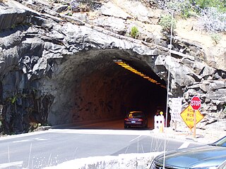
The Wawona Tunnel is a highway tunnel in Yosemite National Park. It, and Tunnel View just beyond its east portal, were completed in 1933.

The Generals' Highway Stone Bridges, built in 1930, are part of the Generals' Highway from the General Grant Grove of giant sequoias in Kings Canyon National Park through Sequoia National Park. One bridge spans the Marble Fork of the Kaweah River in a wooded setting, while the other, similar bridge spans Clover Creek in a bare canyon.

The South Fork Merced River is the largest tributary of the Merced River. Most of the river flows within Yosemite National Park in the Sierra Nevada of California. The river is 43 miles (69 km) long, and its drainage basin covers about 240 square miles (620 km2), of which 109 square miles (280 km2) are in the national park. The average flow at the mouth is 356 cubic feet per second (10.1 m3/s).

The January 1997 flood of the Merced River occurred from December 31, 1996, to January 5, 1997, throughout the Yosemite Valley in Yosemite National Park, Mariposa County, California, US. The flood stands as arguably the park's worst natural disaster to date, and inarguably the worst flood in park history. The Merced River at Happy Isles peaked at 10,100 cubic feet per second during the flood. A book was written on the flood later in 1997 by Mark Goodin titled Yosemite: The 100-Year Flood.
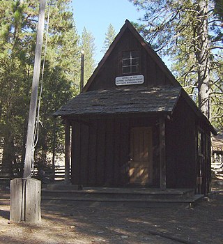
The Acting Superintendent's Headquarters in Yosemite National Park was built by the U.S. Army at Camp A.E. Wood in the Wawona district of the park in 1904 to house the commander of the military administration that operated the park in the years prior to the establishment of the National Park Service. It was moved to the Yosemite Valley in 1906. The Acting Superintendent's Headquarters is the last remaining structure at Wawona associated with the park's military administration. The cabin followed the military to the Yosemite Valley, remaining there until 1958, when it was moved back to Wawona. It is part of the Pioneer Yosemite History Center.

The Yosemite Valley Bridges are eight bridges in the Yosemite Valley of Yosemite National Park, most of them spanning the Merced River. Five of them were built in 1928, with the remainder built between 1921 and 1933. The bridges feature a concrete structure faced with local stone, in an elliptical or three-centered arch configuration. They are notable for their uniform character and for their conformance to tenets of the National Park Service rustic style. Design work for the seven newer bridges was by George D. Whittle of the San Francisco District Office of the U.S. Bureau of Public Roads for the National Park Service. Concrete bridges were chosen at the urging of Thomas Chalmers Vint of the Park Service, in lieu of alternative designs for steel truss bridges, or suspension bridges suggested by the park superintendent.

The Hodgdon Homestead Cabin was built by Jeremiah Hodgdon in 1879 in the Aspen Valley area of what became Yosemite National Park. The two-story log cabin, measuring 22 feet (6.7 m) by 30 feet (9.1 m), was located in an inholding in the park, owned by Hodgdon's descendants. In the 1950s the family proposed to demolish the structure. The National Park Service acquired it and moved it to its Pioneer Yosemite History Center at Wawona, where the restored cabin is part of an exhibit on early settlement and development of the Yosemite area. In addition to housing Hogdon, the cabin housed workers on the Great Sierra Wagon Road in the 1880s, as a patrol cabin for U.S. Army troops who managed the new national park in the 1890s, and as a historic landmark at the old Aspen Valley Resort.

The Chris Jorgensen Studio is a one-room log building, built in 1904 as an artist's studio for Chris Jorgensen in the Yosemite Valley. Jorgensen, an instructor and assistant director of the California School of Fine Arts, arrived in Yosemite in the 1890s. Jorgensen studied and depicted local Native Americans from 1899, collecting native basketwork. The National Park Service acquired the Jorgensen Studio in 1919, calling it the Yosemite Museum. Jorgensen donated his basket collection to the museum in 1923. Jorgensen's widow, Angela Ghiardelli, donated many of Jorgensen's works to the museum following his death in 1935.
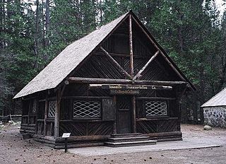
The Pioneer Yosemite History Center is an assembled collection of historic buildings from Yosemite National Park that is located in Wawona, California. Visitors can walk around the buildings year round, and the interiors are open in the summer on a limited basis. There are also special programs and carriage rides in the summer.

The California Powder Works Bridge is a historic covered bridge in Santa Cruz, California. It is a Smith truss bridge, built across the San Lorenzo River in 1872 by the California Powder Works, an explosives manufacturer whose factory complex stood on the river banks. The bridge was designated a National Historic Landmark in 2015 as one of the best-preserved national examples of the Smith truss. It is owned and maintained by the Paradise Park Masonic Club, and is open to pedestrian and vehicular traffic, with a posted weight limit of 5 tons.
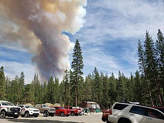
The Washburn Fire was a wildfire that burned in Yosemite National Park near the Mariposa Grove of giant sequoias. The fire was reported on July 7, 2022, in the lower Mariposa Grove area near the Washburn trail, for which the fire is named. The fire quickly attracted national attention due in part to the role the Mariposa Grove played in the establishment of Yosemite National Park and the National Park Service.

The Sentinel Hotel, originally known as the Yosemite Falls Hotel, was a hotel located in Yosemite Valley, California in the United States. Built in 1876, it was open until the early 1900s. Situated on the banks of the Merced River and across the Sentinel Bridge, the hotel had views of Half Dome and Yosemite Falls. The hotel, originally established during the stagecoach era, subsequently grew into a favored destination for tourists journeying to Yosemite via railway and stagecoach. Despite multiple renovations and changes in ownership, the Sentinel Hotel's relevance declined with the advent of modern hospitality services. The entire complex was eventually dismantled between 1938 and 1941.


