
Yosemite National Park is an American national park in the western Sierra Nevada of Central California, bounded on the southeast by Sierra National Forest and on the northwest by Stanislaus National Forest. The park is managed by the National Park Service and covers an area of 748,436 acres and sits in four counties: centered in Tuolumne and Mariposa, extending north and east to Mono and south to Madera County. Designated a World Heritage Site in 1984, Yosemite is internationally recognized for its granite cliffs, waterfalls, clear streams, giant sequoia groves, lakes, mountains, meadows, glaciers, and biological diversity. Almost 95% of the park is designated wilderness.
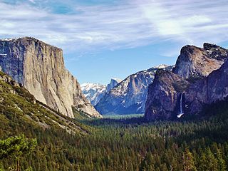
Yosemite Valley is a glacial valley in Yosemite National Park in the western Sierra Nevada mountains of Central California. The valley is about 7.5 miles (12 km) long and approximately 3000–3500 feet deep, surrounded by high granite summits such as Half Dome and El Capitan, and densely forested with pines. The valley is drained by the Merced River, and a multitude of streams and waterfalls flow into it, including Tenaya, Illilouette, Yosemite and Bridalveil Creeks. Yosemite Falls is the highest waterfall in North America and is a big attraction especially in the spring, when the water flow is at its peak. The valley is renowned for its natural environment and is regarded as the centerpiece of Yosemite National Park, attracting visitors from around the world.

Tuolumne Meadows is a gentle, dome-studded, sub-alpine meadow area along the Tuolumne River in the eastern section of Yosemite National Park in the United States. Its approximate location is 37°52.5′N119°21′W. Its approximate elevation is 8,619 feet (2,627 m). The term Tuolumne Meadows is also often used to describe a large portion of the Yosemite high country around the meadows, especially in context of rock climbing.

Hetch Hetchy is a valley, a reservoir, and a water system in California in the United States. The glacial Hetch Hetchy Valley lies in the northwestern part of Yosemite National Park and is drained by the Tuolumne River. For thousands of years before the arrival of settlers from the United States in the 1850s, the valley was inhabited by Native Americans who practiced subsistence hunting-gathering. During the late 19th century, the valley was renowned for its natural beauty – often compared to that of Yosemite Valley – but also targeted for the development of water supply for irrigation and municipal interests.

The Merced River, in the central part of the U.S. state of California, is a 145-mile (233 km)-long tributary of the San Joaquin River flowing from the Sierra Nevada into the San Joaquin Valley. It is most well known for its swift and steep course through the southern part of Yosemite National Park, where it is the primary watercourse flowing through Yosemite Valley. The river's character changes dramatically once it reaches the plains of the agricultural San Joaquin Valley, where it becomes a slow-moving meandering stream.

The Tuolumne River flows for 149 miles (240 km) through Central California, from the high Sierra Nevada to join the San Joaquin River in the Central Valley. Originating at over 8,000 feet (2,400 m) above sea level in Yosemite National Park, the Tuolumne drains a rugged watershed of 1,958 square miles (5,070 km2), carving a series of canyons through the western slope of the Sierra. While the upper Tuolumne is a fast-flowing mountain stream, the lower river crosses a broad, fertile and extensively cultivated alluvial plain. Like most other central California rivers, the Tuolumne is dammed multiple times for irrigation and the generation of hydroelectricity.

Mariposa Grove is a sequoia grove located near Wawona, California, United States, in the southernmost part of Yosemite National Park. It is the largest grove of giant sequoias in the park, with several hundred mature examples of the tree. Two of its trees are among the 30 largest giant sequoias in the world. The grove closed on July 6, 2015, for a restoration project and reopened on June 15, 2018.

Human habitation in the Sierra Nevada region of California reaches back 8,000 to 10,000 years ago. Historically attested Native American populations, such as the Sierra Miwok, Mono and Paiute, belong to the Uto-Aztecan and Utian phyla. In the mid-19th century, a band of Native Americans called the Ahwahnechee lived in Yosemite Valley. The California Gold Rush greatly increased the number of non-indigenous people in the region. Tensions between Native Americans and white settlers escalated into the Mariposa War. As part of this conflict, settler James Savage led the Mariposa Battalion into Yosemite Valley in 1851, in pursuit of Ahwaneechees led by Chief Tenaya. The California state military forces burned the tribe's villages, destroyed their food stores, killed the chief's sons, and forced the tribe out of Yosemite. Accounts from the Mariposa Battalion, especially from Dr. Lafayette Bunnell, popularized Yosemite Valley as a scenic wonder.

The John Muir National Historic Site is located in the San Francisco Bay Area, in Martinez, Contra Costa County, California. It preserves the 14-room Italianate Victorian mansion where the naturalist and writer John Muir lived, as well as a nearby 325-acre tract of native oak woodlands and grasslands historically owned by the Muir family. The main site is on the edge of town, in the shadow of State Route 4, also known as the "John Muir Parkway."

Merced station is an Amtrak intercity rail station located in Merced, California, United States. The station is served by seven daily round trips of the San Joaquin and is a major transfer point for YARTS buses serving Yosemite National Park. Merced station has a single side platform adjacent to the western track of the BNSF Stockton Subdivision.
The LeConte Memorial Lodge, now known as the Yosemite Conservation Heritage Center, is a structure in Yosemite National Park in California, United States. LeConte is spelled variously as Le Conte or as Leconte. Built in 1903 by the Sierra Club, it is nearly unique within the National Park Service system as a high-quality example of Tudor Revival architecture, and is an important early expression of the Club's mission. The lodge was declared a National Historic Landmark in 1987.

The Sánchez Adobe Park, home to the Sánchez Adobe, is located in Pacifica, California, at 1000 Linda Mar Boulevard, on the north bank of San Pedro Creek, approximately 0.91 miles (1,470 m) from the Pacific Ocean in Linda Mar Valley. The 5.46-acre (2.21 ha) county park, established in 1947 contains the Sanchez Adobe Historical site, designated a National Register Historical District in 1976 and is California registered landmark 391.

Architectural Resources Group is a firm that was founded in 1980 by Bruce Judd and Steve Farneth in San Francisco, CA. It began by providing professional services in the fields of architecture and urban planning with particular expertise in the area of historic preservation. In 2000, David Wessel, a Principal of ARG, founded a separate conservation-contracting division, ARG Conservation Services which operates under the same roof as ARG. By 2005, the firm had expanded to a full-service architecture firm with 50+ employees. ARG also opened offices in Pasadena serving Southern California, and Portland, Oregon, serving the Pacific Northwest.

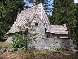
The Parsons Memorial Lodge is a small building built in 1915 by the Sierra Club at the northern end of Tuolumne Meadows of Yosemite National Park. It was one of the earliest structures built of stone in a national park.

Curry Village is a resort in Mariposa County, California in Yosemite National Park within the Yosemite Valley.

The Yosemite Village Historic District encompasses the primary built-up section of the Yosemite Valley as it was developed by the National Park Service for Yosemite National Park. The district includes visitor services areas, park personnel residences and administrative facilities. It is located to the north of the Merced River. The district includes the National Historic Landmark Rangers' Club.

The Yosemite Valley Bridges are eight bridges in the Yosemite Valley of Yosemite National Park, most of them spanning the Merced River. Five of them were built in 1928, with the remainder built between 1921 and 1933. The bridges feature a concrete structure faced with local stone, in an elliptical or three-centered arch configuration. They are notable for their uniform character and for their conformance to tenets of the National Park Service rustic style. Design work for the seven newer bridges was by George D. Whittle of the San Francisco District Office of the U.S. Bureau of Public Roads for the National Park Service. Concrete bridges were chosen at the urging of Thomas Chalmers Vint of the Park Service, in lieu of alternative designs for steel truss bridges, or suspension bridges suggested by the park superintendent.

The Wawona Covered Bridge is a covered bridge spanning the South Fork of the Merced River near Wawona, California in Yosemite National Park. The bridge was built by Galen Clark, the steward of what was then called the Yosemite Grant, in 1868, without its cladding. The bridge was a major component of Clark's proposed new road from Wawona to the Yosemite Valley. Clark was unable to complete the road, which he sold to the Washburn Group of investors along with the Wawona Hotel. The Washburn Group completed the road to the Yosemite Valley in 1879. It is one of twelve remaining covered bridges in California.

The Yosemite Transportation Company Office, also known as the Wells Fargo Office, was built in the Yosemite Valley in 1910 to house facilities of motor stage and horse stage services between the nearest rail terminal at El Portal and Yosemite National Park. The rustic log structure also provided telegraph and express services.
Daniel Ray Hull (1890–1964), sometimes stated Daniel P. Hull, was an American landscape architect who was responsible for much of the early planning of the built environment the national parks of the United States during the 1920s. Hull planned town sites, designed landscapes, and designed individual buildings for the Park Service, in private practice, and later for the California State Parks. A number of his works are listed on the U.S. National Register of Historic Places.


