
Kitsilano is a neighbourhood located in the city of Vancouver, British Columbia, Canada. Kitsilano is named after Squamish chief August Jack Khatsahlano, and the neighbourhood is located in Vancouver's West Side along the south shore of English Bay, between the neighbourhoods of West Point Grey and Fairview. The area is mostly residential with two main commercial areas, West 4th Avenue and West Broadway, known for their retail stores, restaurants and organic food markets.
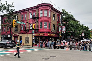
Commercial Drive is a roadway in the city of Vancouver in British Columbia, Canada that extends from Powell Street at its northern extremity, near the waterfront, south through the heart of the Grandview–Woodland neighbourhood to the Victoria Diversion near Trout Lake. The neighbourhood is so dominated by the businesses, cultural facilities, and residents along Commercial Drive that the area is far better known as "The Drive" than by the civic boundaries. The district is one of Vancouver's Business Improvement Areas (BIA).
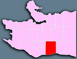
Established in 1907, South Granville is an upscale Business Improvement Area (BIA) and neighbourhood south of Vancouver's downtown core, centred along Granville Street and bordered by the neighbourhoods of Kitsilano, Fairview and Shaughnessy.
Kerrisdale is a neighbourhood in the city of Vancouver, British Columbia, Canada.
Greektown is a general name for an ethnic enclave populated primarily by Greeks or people of Greek ancestry, usually in an urban neighborhood.

Greektown is a social and dining district, located on the Near West Side of the United States' city of Chicago, Illinois. Today, Greektown consists mostly of restaurants and businesses, although a cultural museum and an annual parade and festival still remain in the neighborhood.
Kitsilano Beach is one of the most popular beaches in Vancouver, especially in the warm summer months. Located at the north edge of the Kitsilano neighbourhood, the beach faces out onto English Bay.

Lulu Island is the name of the largest island in the estuary of the Fraser River, located south of Vancouver, British Columbia, and the second-most populous island in British Columbia, after Vancouver Island. The city of Richmond occupies most of the island, while a small section at the eastern tip, known as Queensborough, is part of the city of New Westminster.

The 99 B-Line is an express bus line with bus rapid transit elements in Metro Vancouver, British Columbia, Canada. It travels along Broadway, a major east–west thoroughfare, and connects the University of British Columbia (UBC) to Commercial–Broadway station on the SkyTrain system. It is operated by Coast Mountain Bus Company and funded by TransLink.

Arbutus Ridge is an affluent residential neighbourhood in Vancouver's West Side. It is bordered by 16th Avenue in the north, 41st Avenue in the south, Mackenzie Street in the west, and East Boulevard in the east. The neighbourhood is characterized by larger than average lot sizes, with stately homes on tree-lined streets.

East Vancouver is a region within the city of Vancouver, British Columbia, Canada. Geographically, East Vancouver is bordered to the north by Burrard Inlet, to the south by the Fraser River, and to the east by the city of Burnaby. East Vancouver is divided from Vancouver's "West Side" by Ontario Street.
Mount Pleasant is a neighbourhood in the city of Vancouver, British Columbia, Canada, stretching from Cambie Street to Clark Drive and from Great Northern Way and 2nd, to 16th and Kingsway. The neighbourhood, once characterized as working-class, has undergone a process of gentrification since the early 1990s, including the area around the Main Street and Broadway intersection.

Madrona School Society is a not-for-profit independent school located in Vancouver, British Columbia, with a focus on gifted education. Subjects are taught in small groups based on students' ability levels. On average, the student-teacher ratio is between 6:1 and 14:1. Currently, the school offers Kindergarten through Grade 8.
Sunset is the most ethnically diverse neighbourhood in Vancouver, British Columbia. It is located in the south-east quadrant of the city. Surrounding the multicultural Fraser Street district, Sunset is bordered by both the Marpole and Oakridge neighbourhoods to the west, and the Victoria-Fraserview neighbourhood to the east.

Shaughnessy is an almost-entirely residential neighbourhood in Vancouver, British Columbia, Canada, spanning about 447 hectares in a relatively central locale. It is bordered by 16th Avenue to the north, 41st Avenue to the south, Oak Street to the east, and East Boulevard to the west. The older section of the neighbourhood, called "First Shaughnessy," is considered more prestigious and is bordered by 16th Avenue to the north, King Edward Avenue to the south, Oak Street to the east, and East Boulevard to the west. In 2016, the population was approximately 8,810. It was named after Thomas Shaughnessy, 1st Baron Shaughnessy, former president of the Canadian Pacific Railway.

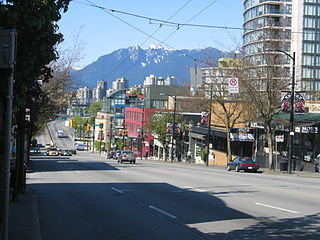
Broadway is a major east–west thoroughfare in the city of Vancouver, British Columbia, Canada. In Vancouver's numbered avenue grid system, it runs in place of a 9th Avenue, between 8th and 10th. The street has six lanes for most of its course. Portions of the street carry the British Columbia Highway 7 designation.

Vanier Park is a municipal park located in the Kitsilano neighbourhood of Vancouver, British Columbia, Canada, created in 1967. It is home to the Museum of Vancouver, the Vancouver Maritime Museum, the City of Vancouver Archives, and the H.R. MacMillan Space Centre. It is also the site of the ancestral Squamish settlement of Sen̓áḵw, which was destroyed by the Provincial government 54 years earlier.
The history of Greeks in Baltimore dates back to the late 19th and early 20th centuries. Baltimore is home to one of the largest Greek American communities in the United States. The community is centered in the Greektown and Highlandtown neighborhoods of East Baltimore.

Arbutus is a planned underground station on the Millennium Line of Metro Vancouver's SkyTrain rapid transit system. It will be located at the northeast corner of the intersection of West Broadway and Arbutus Street in the Kitsilano neighbourhood of Vancouver, British Columbia, Canada, and will be the western terminus of the Millennium Line when completed. Originally scheduled to open in 2025, the station's projected opening was pushed back to early 2026 in November 2022.

