Sunset, Vancouver

Last updated
Sunset
Neighbourhood
Vancouver Sunset.jpg
Location of the Sunset neighbourhood in Vancouver
15 Metro Vancouver Regional District British Columbia.svg
Red pog.svg
Sunset
Location in Metro Vancouver
Coordinates: 49°13′05″N123°03′58″W / 49.218°N 123.066°W / 49.218; -123.066
CountryFlag of Canada (Pantone).svg  Canada
Province British Columbia
City Vancouver
Government
   MP Liberal Harjit Sajjan
(Vancouver South)
   MLAs NDP George Chow
(Vancouver-Fraserview)
Area
[1]
  Total6.26 km2 (2.42 sq mi)
Population
 (2016) [1]
  Total36,500
  Density5,830.6/km2 (15,101/sq mi)
Website https://vancouver.ca/news-calendar/sunset.aspx

Sunset is the most ethnically diverse neighbourhood in Vancouver, British Columbia. It is located in the south-east quadrant of the city. Surrounding the multicultural Fraser Street district, Sunset is bordered by both the Marpole and Oakridge neighbourhoods to the west, and the Victoria-Fraserview neighbourhood to the east.

Contents

History

Development of the Sunset neighbourhood first took place in the 1860s. At the time, the area was part of the District of South Vancouver and consisted mostly of farmland alongside a cluster of homes. [2] Extensive logging took place along the south slope of Vancouver during the late 19th into early 20th century, prompting communities such as Sunset to rapidly industrialize. [3]

In 1929, the District of South Vancouver amalgamated with the City of Vancouver, thus incorporating Sunset as a part of the city. The neighbourhood remained quite rural until the 1940s, when a large wave immigrants from central and eastern Europe moved into the area. [4] Many new German immigrants established churches, most of which remain to this day. [5] [4]

Beginning in the 1950s, into the 1960s and 1970s, another large wave of immigrants moved into Sunset. [6] Primarily Sikhs from the Punjab region of South Asia, the new immigrants founded the Punjabi Market (Little India) on Main Street and presided over the last final large scale development in the neighbourhood with the construction of hundreds of Vancouver Specials. [7] [4] As most development in the area ceased in the 1980s, these homes continue to be a mainstay across southeast Vancouver.

Today, the neighbourhood is among the most ethnically diverse across Metro Vancouver and continues the serve as one of several centres of the South Asian community in Vancouver.

Geography

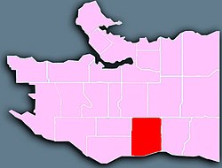
Sunset lies between E 41st Avenue, Ontario St, Knight St and the Fraser River.

Commercial districts in Sunset are situated on Fraser Street between 41st and 51st avenues; named as Vancouver's most multicultural neighbourhood, the Fraser district features many South Asian, Chinese, Filipino and European businesses. [8] [4]

Another commercial district in Sunset is the Punjabi Market (also known as Little India) [9] which is situated on Main Street and 49th Avenue.

Like most of south-east Vancouver, the area used to be predominantly working class but rising house prices elsewhere have made the area increasingly popular with young professionals and families who can no longer afford houses in areas such as the west side.[ citation needed ]

Demographics

The neighbourhood contains the largest South Asian (33.6%) and Punjabi speaking (23%) population in the city.

Panethnic groups in the Sunset neighbourhood (2001−2016)
Panethnic
group
2016 [10] 2006 [11] 2001 [12]
Pop. %Pop.%Pop.%
South Asian 12,12013,14011,360
East Asian [lower-alpha 1] 8,6009,0109,570
Southeast Asian [lower-alpha 2] 6,8805,1504,445
European [lower-alpha 3] 5,6505,7806,455
Indigenous 535365245
Latin American 695665435
Middle Eastern [lower-alpha 4] 340380100
African 350350260
Other/Multiracial [lower-alpha 5] 910475395
Total responses36,07535,23033,275
Total population36,50035,30533,425
Note: Totals greater than 100% due to multiple origin responses

Notes

  1. Statistic includes total responses of "Chinese", "Korean", and "Japanese" under visible minority section on census.
  2. Statistic includes total responses of "Filipino" and "Southeast Asian" under visible minority section on census.
  3. Statistic includes all persons that did not make up part of a visible minority or an indigenous identity.
  4. Statistic includes total responses of "West Asian" and "Arab" under visible minority section on census.
  5. Statistic includes total responses of "Visible minority, n.i.e." and "Multiple visible minorities" under visible minority section on census.

Related Research Articles

<span class="mw-page-title-main">West End, Vancouver</span> Neighbourhood in Vancouver, British Columbia, Canada

The West End is a neighbourhood in Vancouver, British Columbia, Canada, located between the Coal Harbour neighbourhood and the financial and central business districts of Downtown Vancouver to the east, Stanley Park to the northwest, the English Bay to the west, and Kitsilano to the southwest across the False Creek opening.

<span class="mw-page-title-main">Kerrisdale</span> Neighborhood in Vancouver, BC, Canada

Kerrisdale is a neighbourhood in the city of Vancouver, British Columbia, Canada.

<span class="mw-page-title-main">Hastings–Sunrise</span> Neighbourhood of Vancouver in British Columbia, Canada

Hastings–Sunrise is a neighbourhood located in the northeastern corner of the city of Vancouver, British Columbia.

<span class="mw-page-title-main">Strathcona, Vancouver</span> Neighbourhood in Vancouver, Metro Vancouver

Strathcona is the oldest residential neighbourhood of Vancouver, British Columbia, Canada. Officially a part of the East Side, it is bordered by Downtown Vancouver's Chinatown neighbourhood and the False Creek inlet to the west, Downtown Eastside to the north, Grandview-Woodland to the east, and Mount Pleasant to the south of Emily Carr University and the Canadian National Railway and Great Northern Railway classification yards.

<span class="mw-page-title-main">Marpole</span> Neighbourhood in Vancouver, British Columbia, Canada

Marpole, originally a Musqueam village named c̓əsnaʔəm, is a mostly residential neighbourhood of 23,832 in 2011, located on the southern edge of the city of Vancouver, British Columbia, immediately northeast of Vancouver International Airport, and is approximately bordered by Angus Drive to the west, 57th Avenue to the north, Ontario Street to the east and the Fraser River to the south. It has undergone many changes in the 20th century, with the influx of traffic and development associated with the construction of the Oak Street Bridge and the Arthur Laing Bridge.

<span class="mw-page-title-main">Kensington–Cedar Cottage</span> Neighbourhood in Vancouver, British Columbia, Canada

Kensington–Cedar Cottage is one of the most ethnically diverse neighbourhoods in east Vancouver, British Columbia, Canada. The neighbourhood is approximately 7.23 square kilometres (2.79 sq mi) in area.

<span class="mw-page-title-main">Downtown Vancouver</span> Neighbourhood of Vancouver in British Columbia, Canada

Downtown Vancouver is the central business district and the city centre neighbourhood of Vancouver, Canada, on the northwestern shore of the Burrard Peninsula in the Lower Mainland region of British Columbia. It occupies most of the north shore of the False Creek inlet, which cuts into the Burrard Peninsula creating the Downtown Peninsula, where the West End neighbourhood and Stanley Park are also located.

<span class="mw-page-title-main">Riley Park, Vancouver</span> Neighbourhood in Vancouver, British Columbia, Canada

Riley Park, sometimes also known as Riley Park–Little Mountain, is a neighbourhood in Vancouver, British Columbia. Its boundaries are 41st Avenue to the south, 16th Avenue to the north, Cambie Street to the west, and Fraser Street to the east. The main commercial thoroughfare of the neighbourhood is Main Street.

<span class="mw-page-title-main">Arbutus Ridge</span> Neighbourhood in British Columbia, Canada

Arbutus Ridge is an affluent residential neighbourhood in Vancouver's West Side. It is bordered by 16th Avenue in the north, 41st Avenue in the south, Mackenzie Street in the west, and East Boulevard in the east. The neighbourhood is characterized by larger than average lot sizes, with stately homes on tree-lined streets.

<span class="mw-page-title-main">West Point Grey</span> Neighbourhood in Metro Vancouver, British Columbia, Canada

West Point Grey is a neighbourhood in the northwest of the city of Vancouver, British Columbia, Canada. It is on Point Grey and bordered by 16th Avenue to the south, Alma Street to the east, English Bay to the north, and Blanca Street to the west. Notable beaches within West Point Grey include Spanish Banks, Locarno and Jericho. Immediately to the south is Pacific Spirit Regional Park and to the east is Kitsilano.

<span class="mw-page-title-main">Fairview, Vancouver</span> Place in British Columbia, Canada

Fairview is a neighbourhood on the west side of the city of Vancouver, British Columbia, Canada. It runs from False Creek in the north to 16th Avenue in the south, and from Burrard Street in the west to Cambie Street in the east.

<span class="mw-page-title-main">Dunbar–Southlands</span> Neighbourhood in Lower Mainland, British Columbia, Canada

Dunbar–Southlands is a neighbourhood situated on the western side of Vancouver, British Columbia, Canada, that stretches north from the Fraser River and covers most of the land between the mouth of the Fraser and English Bay.

<span class="mw-page-title-main">Killarney, Vancouver</span> Neighbourhood in Vancouver, British Columbia, Canada

Killarney is a neighbourhood in East Vancouver, British Columbia with a population of over 28,000 in 2011 and lies in the far southeast corner of the city. It is on the south slope of the ridge that rises above the Fraser River, and contains a collection of single-family residences with a few multi-family homes as well as the townhouses and high-rises of the Fraserlands development along the river.

<span class="mw-page-title-main">Victoria–Fraserview</span> Neighbourhood in Vancouver, British Columbia, Canada

Victoria–Fraserview is a neighbourhood in the City of Vancouver, set on the south slope of the rise that runs north from the Fraser River and encompassing a large area of residential and commercial development. Surrounding the culturally eclectic Victoria Drive corridor, Victoria–Fraserview is an ethnically diverse area that was one of the earliest areas of settlement in the region.

<span class="mw-page-title-main">Grandview–Woodland</span> Neighbourhood in Lower Mainland, British Columbia, Canada

Grandview–Woodland, also commonly known as Grandview–Woodlands, is a neighbourhood in Vancouver, British Columbia, Canada to the east of the downtown area, stretching south from the shores of Burrard Inlet and encompassing portions of the popular Commercial Drive area. It is a mature neighbourhood in Vancouver that is a vibrant mixture of commercial, industrial, single-family and multi-family residential with a rich ethnic history and features.

<span class="mw-page-title-main">Mount Pleasant, Vancouver</span> Neighborhood of Vancouver, British Columbia, Canada

Mount Pleasant is a neighbourhood in the city of Vancouver, British Columbia, Canada, stretching from Cambie Street to Clark Drive and from Great Northern Way and 2nd, to 16th and Kingsway. The neighbourhood, once characterized as working-class, has undergone a process of gentrification since the early 1990s, including the area around the Main Street and Broadway intersection.

<span class="mw-page-title-main">Oakridge, Vancouver</span> Neighbourhood in Vancouver, British Columbia, Canada

Oakridge is a neighbourhood in Vancouver, British Columbia, Canada, with a multicultural residential and commercial area. It had a population of 13,030 in 2016, of which approximately 50 percent have Chinese as their mother tongue.

<span class="mw-page-title-main">Renfrew–Collingwood</span> Neighbourhood in Vancouver, British Columbia, Canada

Renfrew–Collingwood is a large neighbourhood that lies on the eastern side of Vancouver, British Columbia, Canada, on its boundary with Burnaby and encompassing an area that was one of the earlier developed regions of the city. It is a diverse area that includes a substantial business community in several areas, as well as some of the fastest-growing residential sectors of Vancouver. In 2011, the neighbourhood had a population of 50,500, 38.4% of whom claim Chinese as their first language.

<span class="mw-page-title-main">Shaughnessy, Vancouver</span> Neighbourhood in Vancouver, British Columbia, Canada

Shaughnessy is an almost-entirely residential neighbourhood in Vancouver, British Columbia, Canada, spanning about 447 hectares in a relatively central locale. It is bordered by 16th Avenue to the north, 41st Avenue to the south, Oak Street to the east, and East Boulevard to the west. The older section of the neighbourhood, called "First Shaughnessy," is considered more prestigious and is bordered by 16th Avenue to the north, King Edward Avenue to the south, Oak Street to the east, and East Boulevard to the west. In 2016, the population was approximately 8,810. It was named after Thomas Shaughnessy, 1st Baron Shaughnessy, former president of the Canadian Pacific Railway.

<span class="mw-page-title-main">South Cambie</span>

South Cambie is a neighbourhood in the city of Vancouver, British Columbia, Canada, that is generally considered one of the smallest neighbourhoods in the city, both in size and in population. It is wedged between one of the city's largest parks and the upscale neighbourhood of Shaughnessy, and is known for a large cluster of medical facilities.

References

  1. 1 2 "Sunset; Community Profiles" (PDF). vancouver.ca. Government of the City of Vancouver. Retrieved March 12, 2020.
  2. "Sunset: The neighbourhood at a glance".
  3. "Sunset".
  4. 1 2 3 4 Kevin Chong (December 16, 2022). "Sunset⁠—The Buried History of a South Vancouver Neighbourhood". Montecristo Magazine. Retrieved February 23, 2023.
  5. "Vancouver neighbourhoods: Sunset".
  6. Campbell, Michael Graeme (1977). The Sikhs of Vancouver : a case study in minority-host relations (Thesis). University of British Columbia. doi:10.14288/1.0094087.
  7. "Vancouver Special Sunset Project" (PDF). Archived from the original (PDF) on 2017-07-05. Retrieved 2019-05-17.
  8. "Economy trumps all in culturally diverse Vancouver South". The Globe And Mail. March 30, 2011.
  9. "Vancouver's Little India: Inside the Punjabi Market District". Inside Vancouver. Retrieved November 15, 2021.
  10. Open Data Portal, City Of Vancouver (2018-04-10). "Census local area profiles 2016". opendata.vancouver.ca. Retrieved 2023-03-20.
  11. Open Data Portal, City Of Vancouver (2013-03-25). "Census local area profiles 2006". opendata.vancouver.ca. Retrieved 2023-03-20.
  12. Open Data Portal, City Of Vancouver (2013-03-25). "Census local area profiles 2001". opendata.vancouver.ca. Retrieved 2023-03-20.

49°13′26″N123°05′20″W / 49.224°N 123.089°W / 49.224; -123.089