
Cambie Street is a street in Vancouver, British Columbia, Canada. It is named for Henry John Cambie, chief surveyor of the Canadian Pacific Railway's western division.
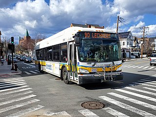
The Massachusetts Bay Transportation Authority (MBTA) operates 152 bus routes in the Greater Boston area. The MBTA has a policy objective to provide transit service within walking distance for all residents living in areas with population densities greater than 5,000 inhabitants per square mile (1,900/km2) within the MBTA's service district. Much of this service is provided by bus. In 2022, the system had a ridership of 83,623,600, or about 319,400 per weekday as of the first quarter of 2023.
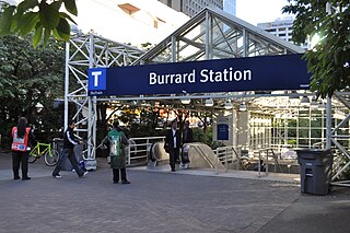
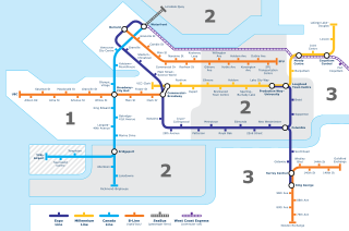
Burrard is an underground station on the Expo Line of Metro Vancouver's SkyTrain rapid transit system. The station is located in Downtown Vancouver on Burrard Street, where Melville and Dunsmuir Streets meet, and is the western terminus of the R5 Hastings St that provides service to Simon Fraser University.

Granville is an underground station on the Expo Line of Metro Vancouver's SkyTrain rapid transit system. The station is located in Downtown Vancouver on the portion of Granville Street that is known as the Granville Mall. The station is accessible from the surface via entrances on Granville Street and Seymour Street, and the Dunsmuir entrance between Granville and Seymour.

Main Street–Science World is an elevated station on the Expo Line of Metro Vancouver's SkyTrain rapid transit system in Vancouver, British Columbia, Canada. The station is accessible from both sides of Main Street at the intersection of Main Street and Terminal Avenue and is adjacent to Pacific Central Station, the city's inter-city railway and bus terminal.

Coast Mountain Bus Company (CMBC) is the contract operator for bus transit services in Metro Vancouver and is a wholly owned subsidiary of the South Coast British Columbia Transportation Authority, known locally as TransLink, the entity responsible for public transit in the region. The buses form part of the integrated transit network of the Lower Mainland.

The 98 B-Line was a bus rapid transit line in Metro Vancouver, British Columbia, Canada. It linked Richmond to Downtown Vancouver, with a connection to Vancouver International Airport. It travelled mainly along Granville Street in Vancouver and a dedicated bus lane on No. 3 Road in Richmond. It was operated by Coast Mountain Bus Company and was funded by TransLink. The route was 16 kilometres (9.9 mi) long. The line carried over 18,000 passengers daily. It was discontinued on September 7, 2009, two and a half weeks after the opening of the Canada Line, which replaced it.

The 99 B-Line is an express bus line with bus rapid transit elements in Metro Vancouver, British Columbia, Canada. It travels along Broadway, a major east–west thoroughfare, and connects the University of British Columbia (UBC) to Commercial–Broadway station on the SkyTrain system. It is operated by Coast Mountain Bus Company and funded by TransLink.

Downtown Vancouver is the central business district and the city centre neighbourhood of Vancouver, Canada, on the northwestern shore of the Burrard Peninsula in the Lower Mainland region of British Columbia. It occupies most of the north shore of the False Creek inlet, which cuts into the Burrard Peninsula creating the Downtown Peninsula, where the West End neighbourhood and Stanley Park are also located.
Transportation in Vancouver, British Columbia, has many of the features of modern cities worldwide. Unlike many large metropolises, Vancouver has no freeways into or through the downtown area. A proposed freeway through the downtown was rejected in the 1960s by a coalition of citizens, community leaders and planners. This event "signalled the emergence of a new concept of the urban landscape" and has been a consistent element of the city's planning ever since.

Marine Drive is an elevated station on the Canada Line of Metro Vancouver's SkyTrain rapid transit system. The station is located at the intersection of Cambie Street and SW Marine Drive in Vancouver, British Columbia.

Vancouver City Centre is an underground station on the Canada Line of Metro Vancouver's SkyTrain rapid transit system. The station is located on Granville Street, between West Georgia Street and Robson Street in Downtown Vancouver, and serves the shopping and entertainment districts along Granville and Robson streets, and the office and shopping complexes of Pacific Centre and Vancouver Centre.

Marpole Loop is a public transit exchange in the Marpole neighbourhood of Vancouver, British Columbia, Canada. The exchange is a part of Metro Vancouver's TransLink transit network. It is the southernmost transit exchange located within the city of Vancouver.
Kootenay Loop is a bus loop in Vancouver, British Columbia, Canada. It is the easternmost major transit exchange in the city of Vancouver, with routes serving Vancouver, Burnaby, North Vancouver and the Tri-Cities.

The Crosstown Line is a public transit line in Brooklyn, New York City, running along Van Brunt Street and Manhattan Avenue between Red Hook and Long Island City, Queens. Originally a streetcar line, it is now the B61 and the B62 bus routes. The northern section, the B62, is operated by MTA New York City Bus' Grand Avenue Depot in Maspeth, Queens, and the southern section is the B61, operated by MTA New York City Bus' Jackie Gleason Depot in Sunset Park. The entire route was a single line, the B61, until January 3, 2010; the B62 was previously a separate, parallel route between Downtown Brooklyn and Greenpoint, now part of the B43 route. The streetcar line, B61 and the original B62 previously operated from the now-closed Crosstown Depot in Greenpoint.
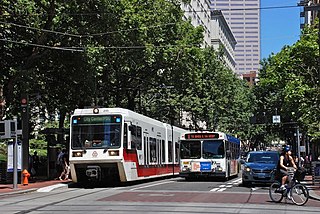
The Portland Transit Mall is a 1.2-mile (1.9 km) public transit corridor that travels north–south through the center of downtown in Portland, Oregon, United States. It comprises a pair of one-way streets—6th Avenue for northbound traffic and 5th Avenue for southbound—along which two of three lanes are restricted to transit buses and light rail vehicles only. As of September 2022, the corridor is served by the Green, Orange, and Yellow lines of MAX Light Rail; Frequent Express; and over a dozen local bus routes, all of which are services of TriMet, the transit agency operating within the Oregon side of the Portland metropolitan area. C-Tran, the transit agency for Clark County, Washington, additionally serves it with two express bus routes—#105 I-5 Express and #164 Fisher’s Landing Express.
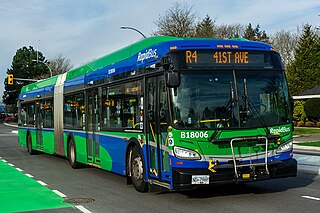
The R4 41st Ave is an express bus route with bus rapid transit elements in Metro Vancouver, British Columbia, Canada. Part of TransLink's RapidBus network, it replaced the 43 Express that travelled along 41st Avenue, a major east–west route that connects the University of British Columbia (UBC) to the SkyTrain system's Oakridge–41st Avenue station on the Canada Line and Joyce–Collingwood station on the Expo Line.
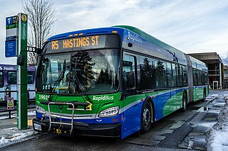
The R5 Hastings St is an express bus service with bus rapid transit elements in Metro Vancouver, Canada. Part of TransLink's RapidBus network, it travels along Hastings Street, a major east–west route, and connects Simon Fraser University to the SkyTrain system's Burrard station on the Expo Line in Downtown Vancouver. It replaced the 95 B-Line route on January 6, 2020.

Commercial–Broadway is a rapid transit station complex in Metro Vancouver's SkyTrain system in Vancouver, British Columbia, Canada. It serves an elevated portion of the Expo Line and a below-grade portion of the Millennium Line. It is a major transit hub, with the third-highest number of boardings of any SkyTrain station, and a terminus of the region's busiest bus route, the 99 B-Line.

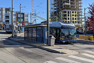
The Vancouver trolley bus system forms part of the TransLink public transport network serving Metro Vancouver in the Canadian province of British Columbia. Opened in 1948, the system was originally owned and operated by the British Columbia Electric Railway. By 1954, Vancouver had the largest trolley bus fleet in Canada, with 327 units, and the fleet grew to an all-time peak of 352 in early 1957. There were 19 routes by 1955 and a peak of 20 by the second quarter of 1957. The last route to open in the 1950s was the only express trolley bus service that ever existed in Canada. Several, mostly short, extensions to the system were constructed in the 1980s and later.


