Financial District, Vancouver

Last updated
Financial District
Business District
Downtown Vancouver Sunset.jpg
Vancouver (British Columbia) Downtown - OpenStreetMap.png
Red pog.svg
Financial District
Location in Vancouver
Coordinates: 49°16′54″N123°07′04″W / 49.281762°N 123.117718°W / 49.281762; -123.117718
CountryFlag of Canada (Pantone).svg  Canada
Province Flag of British Columbia.svg  British Columbia
City Vancouver
Time zone UTC-8 (PST)
  Summer (DST) UTC-7 (PDT)

The Financial District is a highrise office commercial area within the central business district of Vancouver, British Columbia, Canada. Located roughly along Burrard and West Georgia Streets on the Downtown Peninsula, the Financial District contains more than 60% of Greater Vancouver's office space, and is home to headquarters of forest products and mining companies. The area contains numerous federal and non-governmental organizations (NGO) offices, overseas missions and consulates, and headquarter and branch offices of national and international banks and financial services, accounting and law firms, and luxury hotels.

Contents

History

The city's financial district emerged in the early 1900s when the building boom in the area began. From 1907 to 1913 a number of office buildings were built in the area along West Hastings Street: [1]

The financial district only expanded after the 1970s, with much of the new buildings emerging after the 1980s.

Vancouver's financial district is compact area when compared to other world cities. Most of the skyscrapers in the district are regional offices of the Big Five Canadian-based or International banks and various financial services institutions.

Major skyscrapers and buildings

Transit

Vancouver's Financial District is well served by numerous local and commuter bus routes running along Burrard and Georgia streets. In the heart of the Financial District lies Burrard Station, providing metro rail access to thousands of commuters daily via SkyTrain Expo Line. A short distance to the north is Waterfront Station which provides access to Seabus, West Coast Express commuter rail, and SkyTrain Canada Line.

See also

Related Research Articles

<span class="mw-page-title-main">Hotel Vancouver</span> Hotel located in downtown Vancouver, British Columbia

The Fairmont Hotel Vancouver, formerly and still informally called the Hotel Vancouver, is a historic hotel in Vancouver, British Columbia. Located along West Georgia Street the hotel is situated within the city's Financial District, in Downtown Vancouver. The hotel was designed by two architects, John Smith Archibald, and John Schofield. The hotel is currently managed by Fairmont Hotels and Resorts.

<span class="mw-page-title-main">West End, Vancouver</span> Neighbourhood in Vancouver, British Columbia, Canada

The West End is a neighbourhood in Vancouver, British Columbia, Canada, located between the Coal Harbour neighbourhood and the financial and central business districts of Downtown Vancouver to the east, Stanley Park to the northwest, the English Bay to the west, and Kitsilano to the southwest across the False Creek opening.

<span class="mw-page-title-main">Waterfront station (Vancouver)</span> Metro Vancouver public transportation facility

Waterfront station is a major intermodal public transportation facility and the main transit terminus in Vancouver, British Columbia, Canada. It is located on West Cordova Street in Downtown Vancouver, between Granville and Seymour Street. The station is also accessible via two other street-level entrances, one on Howe Street to the west for direct access to the Expo Line and another on Granville Street to the south for direct access to the Canada Line.

<span class="mw-page-title-main">Robson Street</span>

Robson Street is a major southeast-northwest thoroughfare in downtown and West End of Vancouver, British Columbia, Canada. Its core commercial blocks from Burrard Street to Jervis were also known as Robsonstrasse. Its name honours John Robson, a major figure in British Columbia's entry into the Canadian Confederation, and Premier of the province from 1889 to 1892. Robson Street starts at BC Place Stadium near the north shore of False Creek, then runs northwest past Vancouver Library Square, Robson Square and the Vancouver Art Gallery, coming to an end at Lost Lagoon in Stanley Park.

<span class="mw-page-title-main">Granville station (SkyTrain)</span> Metro Vancouver SkyTrain station

Granville is an underground station on the Expo Line of Metro Vancouver's SkyTrain rapid transit system. The station is located in Downtown Vancouver on the portion of Granville Street that is known as the Granville Mall. The station is accessible from the surface via entrances on Granville Street and Seymour Street, and the Dunsmuir entrance between Granville and Seymour.

<span class="mw-page-title-main">Coal Harbour</span> Neighbourhood in Vancouver, British Columbia, Canada

Coal Harbour is the name for a section of Burrard Inlet lying between Vancouver's Downtown Peninsula and the Brockton Point of Stanley Park. It has also now become the name of the neighbourhood adjacent to its southern shoreline.

<span class="mw-page-title-main">Burrard Street</span>

Burrard Street is a major thoroughfare in Vancouver, British Columbia, Canada. It is the central street of Downtown Vancouver and the Financial District. The street is named for Burrard Inlet, located at its northern terminus, which in turn is named for Sir Harry Burrard-Neale.

<span class="mw-page-title-main">Granville Square</span> Prominent tower located in the Financial District within the downtown core of Vancouver

Granville Square is a prominent tower located at 200 Granville Street in the Financial District within the city's downtown core of Vancouver, British Columbia, Canada. Completed in 1973, the building stands at 138.4 metres tall. The tower and its plaza are located atop the tracks of the Canadian Pacific Railway, and adjacent to Waterfront Station.

<span class="mw-page-title-main">Royal Centre (Vancouver)</span> Skyscraper complex located in Downtown Vancouvers Financial District

Royal Centre, also known as RBC Tower or Royal Bank Tower, is a skyscraper complex located at 1055 West Georgia Street in Downtown Vancouver's Financial District. The skyscraper stands at just under 145m tall and 37 storeys. Royal Centre was the tallest building in Vancouver upon completion in 1973 and remained so until it was overtaken by Harbour Centre in 1977.

<span class="mw-page-title-main">98 B-Line</span> Former express bus service in Metro Vancouver, Canada

The 98 B-Line was a bus rapid transit line in Metro Vancouver, British Columbia, Canada. It linked Richmond to Downtown Vancouver, with a connection to Vancouver International Airport. It travelled mainly along Granville Street in Vancouver and a dedicated bus lane on No. 3 Road in Richmond. It was operated by Coast Mountain Bus Company and was funded by TransLink. The route was 16 kilometres (9.9 mi) long. The line carried over 18,000 passengers daily. It was discontinued on September 7, 2009, two and a half weeks after the opening of the Canada Line, which replaced it.

<span class="mw-page-title-main">Bentall Centre (Vancouver)</span> Skyscraper complex in downtown Vancouver, British Columbia

The Bentall Centre is a 1.5 million square foot office complex and underground shopping mall, located in Downtown Vancouver's financial district. It is owned and managed by Hudson Pacific Properties. The shopping mall under the complex is known as "The Shops at Bentall Centre", and includes approximately 50 stores and a food court. The mall has a direct connection to Burrard Station of the SkyTrain network.

<span class="mw-page-title-main">Downtown Vancouver</span> Neighbourhood of Vancouver in British Columbia, Canada

Downtown Vancouver is the central business district and the city centre neighbourhood of Vancouver, Canada, on the northwestern shore of the Burrard Peninsula in the Lower Mainland region of British Columbia. It occupies most of the north shore of the False Creek inlet, which cuts into the Burrard Peninsula creating the Downtown Peninsula, where the West End neighbourhood and Stanley Park are also located.

<span class="mw-page-title-main">Transportation in Vancouver</span>

Transportation in Vancouver, British Columbia, has many of the features of modern cities worldwide. Unlike many large metropolises, Vancouver has no freeways into or through the downtown area. A proposed freeway through the downtown was rejected in the 1960s by a coalition of citizens, community leaders and planners. This event "signalled the emergence of a new concept of the urban landscape" and has been a consistent element of the city's planning ever since.

<span class="mw-page-title-main">Vancouver City Centre station</span> Metro Vancouver SkyTrain station

Vancouver City Centre is an underground station on the Canada Line of Metro Vancouver's SkyTrain rapid transit system. The station is located on Granville Street, between West Georgia Street and Robson Street in Downtown Vancouver, and serves the shopping and entertainment districts along Granville and Robson streets, and the office and shopping complexes of Pacific Centre and Vancouver Centre.

<span class="mw-page-title-main">Downtown Toronto</span> Central business district in Toronto, Ontario, Canada

Downtown Toronto is the main central business district of Toronto, Ontario, Canada. Located entirely within the district of Old Toronto, it is approximately 16.6 square kilometres in area, bounded by Bloor Street to the northeast and Dupont Street to the northwest, Lake Ontario to the south, the Don Valley to the east, and Bathurst Street to the west. It is also the home of the municipal government of Toronto and the Government of Ontario.

<span class="mw-page-title-main">Georgia Street</span>

Georgia Street is an east–west street in the cities of Vancouver and Burnaby, British Columbia, Canada. Its section in Downtown Vancouver, designated West Georgia Street, serves as one of the primary streets for the financial and central business districts, and is the major transportation corridor connecting downtown Vancouver with the North Shore by way of the Lions Gate Bridge. The remainder of the street, known as East Georgia Street between Main Street and Boundary Road and simply Georgia Street within Burnaby, is more residential in character, and is discontinuous at several points.

<span class="mw-page-title-main">Financial District, Toronto</span> Central business district in Ontario, Canada

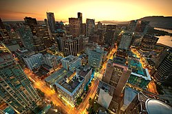
The Financial District is the central business district of Downtown Toronto, Ontario, Canada. It was originally planned as New Town in 1796 as an extension of the Town of York. It is the main financial district in Toronto and is considered the heart of Canada's finance industry. It is bounded roughly by Queen Street West to the north, Yonge Street to the east, Front Street to the south, and University Avenue to the west, though many office towers in the downtown core have been and are being constructed outside this area, which will extend the general boundaries. Examples of this trend are the Telus Harbour, RBC Centre, and CIBC Square.

<span class="mw-page-title-main">Fairmont Pacific Rim</span> Hotel in Vancouver, Canada (opened 2010)

Fairmont Pacific Rim is an upscale hotel and condominium building in Vancouver, British Columbia. It stands at 140 m or 44 stories tall and was completed just prior to the 2010 Winter Olympics on February 4, 2010.

<span class="mw-page-title-main">Architecture of Vancouver</span>

The architecture of Vancouver and the Greater Vancouver area consists of a variety of modern architectural styles, such as the 20th century Edwardian style and the 21st century modernist style, as well as many others. Initially, the city's architects embraced styles and ideas developed in Europe and the United States, with only limited local variation.

References

  1. "Vancouver%27s financial district emerged - Google Search".