Greendale Township, Michigan

Last updated

Greendale Township, Michigan
Greendale Township, MI location.png
Location within Midland County and the state of Michigan
USA Michigan location map.svg
Red pog.svg
Greendale Township
Usa edcp location map.svg
Red pog.svg
Greendale Township
Coordinates: 43°35′56″N84°32′50″W / 43.59889°N 84.54722°W / 43.59889; -84.54722
Country United States
State Michigan
County Midland
Established1882
Government
  SupervisorR. James LeViere
   Clerk Ruth Knapp
Area
[1]
  Total36.1 sq mi (93 km2)
  Land35.4 sq mi (92 km2)
  Water0.7 sq mi (2 km2)
Elevation
673 ft (205 m)
Population
 (2020) [2]
  Total1,731
  Density48.9/sq mi (18.9/km2)
Time zone UTC-5 (Eastern (EST))
  Summer (DST) UTC-4 (EDT)
ZIP Codes
48883 (Shepherd)
48858 (Mount Pleasant)
48640 (Midland)
Area code 989
FIPS code 26-111-34860 [3]
GNIS feature ID1626396 [4]
Website greendaletwpmidcomi.org

Greendale Township is a civil township of Midland County in the U.S. state of Michigan. As of the 2020 census, the township population was 1,731. [2]

Contents

History

In 1875 Col. William L. Sterns and other men from Berea, Ohio, platted a place in the township called "Central City". The effort to form this city failed and the area is now known as Oil City. [5] [6]

Communities

Geography

The township is in western Midland County, bordered to the west by Isabella County. According to the U.S. Census Bureau, the township has a total area of 36.1 square miles (93 km2), of which 35.4 square miles (92 km2) are land and 0.7 square miles (1.8 km2), or 1.94%, are water. [1] The Chippewa River, a tributary of the Tittabawassee River and part of the Saginaw River watershed, flows from west to east across the township.

Demographics

Historical population
CensusPop.Note
1890 151
1900 24763.6%
1910 33736.4%
1920 246−27.0%
1930 536117.9%
1940 85058.6%
1950 751−11.6%
1960 87015.8%
1970 1,10527.0%
1980 1,24412.6%
1990 1,49520.2%
2000 1,78819.6%
2010 1,751−2.1%
2020 1,731−1.1%
U.S. Decennial Census [8]

As of the census [3] of 2000, there were 1,788 people, 616 households, and 482 families residing in the township. The population density was 49.5 inhabitants per square mile (19.1/km2). There were 646 housing units at an average density of 17.9 per square mile (6.9/km2). The racial makeup of the township was 95.81% White, 0.28% African American, 1.45% Native American, 0.28% Asian, 0.62% from other races, and 1.57% from two or more races. Hispanic or Latino of any race were 1.90% of the population.

There were 616 households, out of which 41.6% had children under the age of 18 living with them, 62.2% were married couples living together, 10.4% had a female householder with no husband present, and 21.6% were non-families. 18.5% of all households were made up of individuals, and 6.3% had someone living alone who was 65 years of age or older. The average household size was 2.90 and the average family size was 3.24.

In the township the population was spread out, with 31.9% under the age of 18, 7.8% from 18 to 24, 33.1% from 25 to 44, 19.8% from 45 to 64, and 7.3% who were 65 years of age or older. The median age was 32 years. For every 100 females, there were 93.9 males. For every 100 females age 18 and over, there were 98.5 males.

The median income for a household in the township was $33,587, and the median income for a family was $36,776. Males had a median income of $32,000 versus $21,250 for females. The per capita income for the township was $14,522. About 10.3% of families and 13.7% of the population were below the poverty line, including 18.7% of those under age 18 and 7.0% of those age 65 or over.

Related Research Articles

<span class="mw-page-title-main">Helena Township, Michigan</span> Civil township in Michigan, United States

Helena Township is a civil township of Antrim County in the U.S. state of Michigan. The population was 1,001 at the 2010 census. Helena Township was organized in 1865 by a division of Milton Township. It was named for Helena M. Thayer.

<span class="mw-page-title-main">Milton Township, Antrim County, Michigan</span> Civil township in Michigan, United States

Milton Township is a civil township of Antrim County in the U.S. state of Michigan. The population was 2,204 at the 2010 census.

<span class="mw-page-title-main">Chippewa Township, Chippewa County, Michigan</span> Civil township in Michigan, United States

Chippewa Township is a civil township of Chippewa County in the U.S. state of Michigan. As of the 2010 census, the township population was 213.

<span class="mw-page-title-main">Dafter Township, Michigan</span> Civil township in Michigan, United States

Dafter Township is a civil township of Chippewa County in the U.S. state of Michigan. The population was 1,263 at the 2010 census.

<span class="mw-page-title-main">Detour Township, Michigan</span> Civil township in Michigan, United States

DeTour Township is a civil township of Chippewa County in the U.S. state of Michigan. The population was 807 at the 2010 census. The township is at the extreme eastern tip of the Upper Peninsula.

<span class="mw-page-title-main">Rudyard Township, Michigan</span> Civil township in Michigan, United States

Rudyard Township is a civil township of Chippewa County in the U.S. state of Michigan. As of the 2010 census, the township population was 1,370. In 2023, Rudyard Township was designated the "Snowy Owl Capital of Michigan".

<span class="mw-page-title-main">Chippewa Township, Isabella County, Michigan</span> Civil township in Michigan, United States

Chippewa Township is a civil township of Isabella County in the U.S. state of Michigan. As of the 2000 census, the township population was 4,617. The city of Mount Pleasant is nearby to the west, and the Mount Pleasant post office, with ZIP code 48858, also serves the northern portion of Chippewa Township.

<span class="mw-page-title-main">Deerfield Township, Isabella County, Michigan</span> Civil township in Michigan, United States

Deerfield Township is a civil township of Isabella County in the U.S. state of Michigan. The population was 3,081 at the 2000 census.

<span class="mw-page-title-main">Nottawa Township, Isabella County, Michigan</span> Civil township in Michigan, United States

Nottawa Township is a civil township of Isabella County in the U.S. state of Michigan. The population was 2,225 at the 2020 census.

<span class="mw-page-title-main">Sherman Township, Isabella County, Michigan</span> Civil township in Michigan, United States

Sherman Township is a civil township of Isabella County in the U.S. state of Michigan. The population was 2,616 at the 2000 census.

Chase Township is a civil township of Lake County in the U.S. state of Michigan. The population was 1,194 at the 2000 census.

<span class="mw-page-title-main">Bois Blanc Township, Michigan</span> Civil township in Michigan, United States

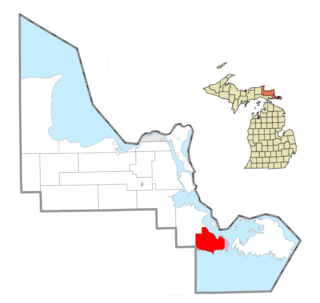
Bois Blanc Township is a civil township of Mackinac County in the U.S. state of Michigan. The population was 100 at the 2020 census. The insular township occupies Bois Blanc Island, as well as some smaller outlying islands within Lake Huron. The nearby Round Island is administered by the city of Mackinac Island.

<span class="mw-page-title-main">Barryton, Michigan</span> Village in Michigan, United States

Barryton is a village in Mecosta County in the U.S. state of Michigan. The population was 405 at the 2020 census, up from 355 in 2010. The village is located in Fork Township on M-66.

Chippewa Township is a civil township of Mecosta County in the U.S. state of Michigan. As of the 2020 census, the township population was 1,227.

Colfax Township is a civil township of Mecosta County in the U.S. state of Michigan. The population was 1,962 at the 2020 census.

Fork Township is a civil township of Mecosta County in the U.S. state of Michigan. The population was 1,627 at the 2020 census.

<span class="mw-page-title-main">Jasper Township, Michigan</span> Civil township in Michigan, United States

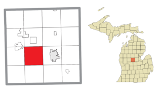
Jasper Township is a civil township of Midland County in the U.S. state of Michigan. The population was 1,060 at the 2020 census.

<span class="mw-page-title-main">Ida Township, Michigan</span> Civil township in Michigan, United States

Ida Township is a civil township of Monroe County in the U.S. state of Michigan. The population was 4,783 at the 2020 census. The township was organized in 1837 and named after local civic leader Ida M. Taylor.

Ferris Township is a civil township of Montcalm County in the U.S. state of Michigan. The population was 1,331 at the 2020 census.

<span class="mw-page-title-main">Riley Township, St. Clair County, Michigan</span> Civil township in Michigan, United States

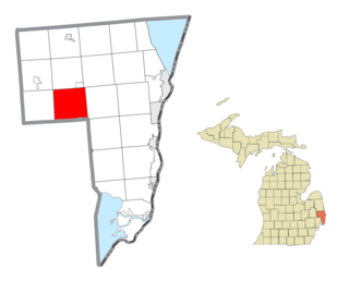
Riley Township is a civil township of St. Clair County in the U.S. state of Michigan. The population was 3,353 at the 2010 Census.

References

Notes

  1. 1 2 "2023 U.S. Gazetteer Files: Michigan". United States Census Bureau. Retrieved October 17, 2023.
  2. 1 2 "P1. Race – Greendale township, Michigan: 2020 DEC Redistricting Data (PL 94-171)". U.S. Census Bureau. Retrieved October 17, 2023.
  3. 1 2 "U.S. Census website". United States Census Bureau . Retrieved January 31, 2008.
  4. U.S. Geological Survey Geographic Names Information System: Greendale Township, Michigan
  5. Knapp, Ruth; Wentz, Dorothy. "A Brief History of Greendale Township" . Retrieved August 28, 2022.
  6. Romig 1986, p. 107.
  7. U.S. Geological Survey Geographic Names Information System: Oil City, Michigan
  8. "Decennial Census Official Publications". U.S. Census Bureau. Retrieved October 17, 2023.

Sources