Larkin Charter Township, Michigan

Last updated
Larkin Township, Michigan
Larkin Charter Township
Larkin Charter Township, MI location.png
Location within Midland County and the state of Michigan
USA Michigan location map.svg
Red pog.svg
Larkin Township
Coordinates: 43°41′33″N84°14′04″W / 43.69250°N 84.23444°W / 43.69250; -84.23444
Country United States
State Michigan
County Midland
Established1879
Government
  SupervisorMaria Sandow
   Clerk Sandra Reardon
Area
[1]
  Total32.06 sq mi (83.0 km2)
  Land32.00 sq mi (82.9 km2)
  Water0.06 sq mi (0.2 km2)
Elevation
682 ft (208 m)
Population
 (2020) [2]
  Total5,331
  Density166.6/sq mi (64.3/km2)
Time zone UTC-5 (Eastern (EST))
  Summer (DST) UTC-4 (EDT)
ZIP Code
48642 (Midland)
Area code 989
FIPS code 26-111-46160 [3]
GNIS feature ID1626592 [4]
Website www.larkintownship.org

Larkin Charter Township is a charter township of Midland County in the U.S. state of Michigan. The population was 5,331 at the 2020 census. [2]

Contents

Geography

The township is in eastern Midland County, bordered to the south by the city of Midland, the county seat, and to the east by Bay County. According to the U.S. Census Bureau, the township has a total area of 32.06 square miles (83.04 km2), of which 32.00 square miles (82.88 km2) are land and 0.06 square miles (0.16 km2), or 0.20%, are water. [1] The west side of the township is drained by Sturgeon Creek, a south-flowing tributary of the Tittabawassee River and part of the Saginaw River watershed, while the east side is drained by tributaries of the Kawkawlin River, which flows east to Lake Huron just north of the mouth of the Saginaw.

Demographics

Historical population
CensusPop.Note
1880 210
1890 877317.6%
1900 702−20.0%
1910 77710.7%
1920 8084.0%
1930 8454.6%
1940 1,06826.4%
1950 1,45135.9%
1960 2,03240.0%
1970 2,50923.5%
1980 3,30331.6%
1990 3,5888.6%
2000 4,51425.8%
2010 5,13613.8%
2020 5,3313.8%
U.S. Decennial Census [5]

As of the census [3] of 2000, there were 4,514 people, 1,502 households, and 1,288 families residing in the township. The population density was 137.8 inhabitants per square mile (53.2/km2). There were 1,542 housing units at an average density of 47.1 per square mile (18.2/km2). The racial makeup of the township was 96.96% White, 0.73% African American, 0.18% Native American, 0.84% Asian, 0.20% from other races, and 1.09% from two or more races. Hispanic or Latino of any race were 1.11% of the population.

There were 1,502 households, out of which 45.7% had children under the age of 18 living with them, 79.1% were married couples living together, 3.9% had a female householder with no husband present, and 14.2% were non-families. 12.1% of all households were made up of individuals, and 3.7% had someone living alone who was 65 years of age or older. The average household size was 3.00 and the average family size was 3.27.

In the township the population was spread out, with 31.6% under the age of 18, 5.8% from 18 to 24, 30.5% from 25 to 44, 25.1% from 45 to 64, and 7.0% who were 65 years of age or older. The median age was 37 years. For every 100 females, there were 103.7 males. For every 100 females age 18 and over, there were 101.3 males.

The median income for a household in the township was $80,177, and the median income for a family was $91,053. Males had a median income of $72,104 versus $31,108 for females. The per capita income for the township was $29,996. About 1.3% of families and 2.5% of the population were below the poverty line, including 1.6% of those under age 18 and 8.8% of those age 65 or over.

Related Research Articles

<span class="mw-page-title-main">Midland County, Michigan</span> County in Michigan, United States

Midland County is a county located in the U.S. state of Michigan. As of the 2020 census, the population was 83,494. The county seat is Midland. The county's name is due to its closeness to the geographical Lower Peninsula's geographical center. It was founded in 1831. However, it was not until 1855 that the county was effectively organized.

<span class="mw-page-title-main">Hampton Township, Michigan</span> Charter township in Michigan, United States

Hampton Charter Township is a charter township of Bay County in the U.S. state of Michigan. The township's population was 9,652 as of the 2010 Census and is included in the Bay City Metropolitan Statistical Area.

<span class="mw-page-title-main">Portsmouth Township, Michigan</span> Charter township in Michigan, United States

Portsmouth Charter Township is a charter township located in Bay County in the U.S. state of Michigan. The township's population was 3,306 as of the 2010 census and is included in the Bay City Metropolitan Statistical Area.

<span class="mw-page-title-main">Genoa Township, Michigan</span> Charter township in Michigan, United States

Genoa Charter Township is a charter township of Livingston County in the U.S. state of Michigan. As of the 2020 census, the township population was 20,692.

<span class="mw-page-title-main">Greendale Township, Michigan</span> Civil township in Michigan, United States

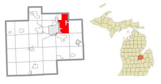
Greendale Township is a civil township of Midland County in the U.S. state of Michigan. As of the 2020 census, the township population was 1,731.

<span class="mw-page-title-main">Midland Township, Michigan</span> Charter township in Michigan, United States

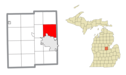
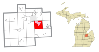
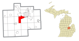
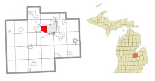
Midland Charter Township is a charter township of Midland County in the U.S. state of Michigan. The population was 2,223 at the 2020 census. The township consists of three non-contiguous segments adjacent to the city of Midland, and the township and city are administered autonomously.

Shelby is a civil township of Oceana County in the U.S. state of Michigan. The population was 3,951 at the 2000 census. The village of Shelby is located within the township.

<span class="mw-page-title-main">Brady Township, Saginaw County, Michigan</span> Civil township in Michigan, United States

Brady Township is a civil township of Saginaw County in the U.S. state of Michigan. As of the 2010 Census, the township population was 2,218.

<span class="mw-page-title-main">Bridgeport, Michigan</span> Census-designated place & unincorporated community in Michigan, United States

Bridgeport is an unincorporated community in Bridgeport Charter Township, Saginaw County in the U.S. state of Michigan. It is also a census-designated place (CDP) for statistical purposes. The population was 6,571 at the 2020 census. Bridgeport is also the name of a post office with ZIP code 48722. The area served by the ZIP code includes the southeast portion of the CDP and includes southeastern portions of Bridgeport Charter Township outside of the CDP as well as portions of southwest Frankenmuth Township and a small area of northeastern Birch Run Township. The remainder of the CDP area is served by the Saginaw ZIP code 48601.

<span class="mw-page-title-main">Bridgeport Charter Township, Michigan</span> Charter township in Michigan, United States

Bridgeport Charter Township is a charter township of Saginaw County in the U.S. state of Michigan. The 2020 Census placed the population at 10,104.

<span class="mw-page-title-main">Buena Vista Charter Township, Michigan</span> Charter township in Michigan, United States

Buena Vista Charter Township is a charter township of Saginaw County in the U.S. state of Michigan. Per the 2020 census, the population was 7,664.

<span class="mw-page-title-main">Carrollton Township, Michigan</span> Civil township in Michigan, United States

Carrollton Township is a civil township of Saginaw County in the U.S. state of Michigan. The population was 6,103 at the 2010 census. Established in 1866, Carrollton contains a full-time police department, fire department, parks and recreation services, as well as its own public school system, Carrollton Public Schools. Along with being located on the Saginaw River, Carrollton offers close access to shopping malls, medical facilities, Saginaw Valley State University, and I-75.

<span class="mw-page-title-main">Freeland, Michigan</span> Census-designated place & unincorporated community in Michigan, United States

Freeland is a census-designated place in Tittabawassee Township, Saginaw County in the U.S. state of Michigan. It is part of the Saginaw-Midland-Bay Metropolitan Area. As of the 2000 census, the CDP population was 5,147. The CDP covers an area in the central portion of Tittabawassee Township. The Freeland post office, ZIP code 48623, serves nearly the entire township, as well as portions of Midland and Williams townships to the north, Frankenlust and Kochville townships to the east, Thomas and Richland townships to the south, and Ingersoll Township to the west.

<span class="mw-page-title-main">Hemlock, Michigan</span> Census-designated place & unincorporated community in Michigan, United States

Hemlock is an unincorporated community in Richland Township, Saginaw County in the U.S. state of Michigan. It is also a census-designated place (CDP) for statistical purposes, but without any legal status as an incorporated municipality. The population of the CDP was 1,585 at the 2000 census. The area included in the CDP is in the south central portion of Richland Township. The Hemlock post office, with ZIP code 48626, serves nearly all of Richland Township, as well as portions of Fremont Township to the south, small areas of Thomas and Swan Creek townships to the southeast, and part of Ingersoll Township to the north in Midland County.

<span class="mw-page-title-main">James Township, Michigan</span> Civil township in Michigan, United States

James Township is a civil township of Saginaw County in the U.S. state of Michigan. The population was 2,023 at the 2010 Census.

<span class="mw-page-title-main">Saginaw Charter Township, Michigan</span> Charter township in Michigan, United States

Saginaw Charter Township is a charter township of Saginaw County in the U.S. state of Michigan. The population was 41,679 at the 2020 census. The city of Saginaw is adjacent to the township to the southeast, but is administratively autonomous.

<span class="mw-page-title-main">Saginaw Township North, Michigan</span> Place in Michigan, United States

Saginaw Township North is a former census-designated place (CDP) in Saginaw County in the U.S. state of Michigan. The CDP was defined for statistical purposes and had no legal status as an incorporated municipality. The population was 24,994 at the 2000 census. The community is located within Saginaw Charter Township and consists of most of the township north of State St., while Saginaw Township South is the area south of State St. This division was purely for statistical purposes and does not reflect any present or historical self-identification of the residents in these areas.

<span class="mw-page-title-main">Saginaw Township South, Michigan</span> Place in Michigan, United States

Saginaw Township South was a census-designated place (CDP) in Saginaw County in the U.S. state of Michigan. The CDP was defined for statistical purposes and had no legal status as an incorporated municipality. The population was 13,801 at the 2000 census. The community is located within Saginaw Charter Township and consists of the township south of State St., while Saginaw Township North is most of the area north of State St. This division is purely for statistical purposes and does not reflect any present or historical self-identification of the residents in these areas.

<span class="mw-page-title-main">Watertown Charter Township, Michigan</span> Charter township in Michigan, United States

Watertown Charter Township is a charter township of Clinton County in the U.S. state of Michigan. The population was 4,836 in the 2010 census, which was an increase from 4,162 at the 2000 census.

<span class="mw-page-title-main">Geneva Township, Midland County, Michigan</span> Civil township in Michigan, United States

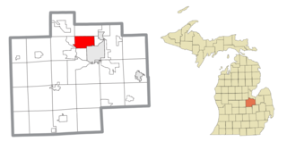
Geneva Township is a civil township of Midland County in the U.S. state of Michigan. The population was 1,065 at the 2020 census.

References

  1. 1 2 "2023 U.S. Gazetteer Files: Michigan". United States Census Bureau. Retrieved October 17, 2023.
  2. 1 2 "P1. Race – Larkin charter township, Michigan: 2020 DEC Redistricting Data (PL 94-171)". U.S. Census Bureau. Retrieved October 17, 2023.
  3. 1 2 "U.S. Census website". United States Census Bureau . Retrieved 2008-01-31.
  4. U.S. Geological Survey Geographic Names Information System: Larkin Charter Township, Michigan
  5. "Decennial Census Official Publications". U.S. Census Bureau. Retrieved October 17, 2023.