Homer Township, Midland County, Michigan

Last updated

Homer Township, Michigan
Homer Township (Midland), MI location.png
Location within Midland County and the state of Michigan
USA Michigan location map.svg
Red pog.svg
Homer Township
Usa edcp location map.svg
Red pog.svg
Homer Township
Coordinates: 43°36′42″N84°19′45″W / 43.61167°N 84.32917°W / 43.61167; -84.32917
Country United States
State Michigan
County Midland
Established1862
Government
  SupervisorRussell Varner
   Clerk Todd Lee
Area
[1]
  Total21.3 sq mi (55 km2)
  Land20.9 sq mi (54 km2)
  Water0.4 sq mi (1 km2)
Elevation
630 ft (192 m)
Population
 (2020) [2]
  Total3,993
  Density191.3/sq mi (73.9/km2)
Time zone UTC-5 (Eastern (EST))
  Summer (DST) UTC-4 (EDT)
ZIP Codes
48640, 48642 (Midland)
48657 (Sanford)
Area code 989
FIPS code 26-111-38980 [3]
GNIS feature ID1626486 [4]
Website www.homertownship.org

Homer Township is a civil township of Midland County in the U.S. state of Michigan. As of the 2020 census, the township population was 3,993. [2]

Contents

Geography

The township is in central Midland County and is bordered to the northeast by the city of Midland, the county seat. According to the United States Census Bureau, the township has a total area of 21.3 square miles (55 km2), of which 20.9 square miles (54 km2) are land and 0.4 square miles (1.0 km2), or 1.88%, are water. [1] The Tittabawassee River crosses the northeast part of the township, and its tributary, the Chippewa River, crosses the center of the township. The Pine River, a tributary of the Chippewa, drains the southern part of the township.

Demographics

Historical population
CensusPop.Note
1870 247
1880 601143.3%
1890 552−8.2%
1900 65719.0%
1910 570−13.2%
1920 5984.9%
1930 75426.1%
1940 1,46794.6%
1950 2,19649.7%
1960 3,30450.5%
1970 3,95919.8%
1980 4,47713.1%
1990 4,235−5.4%
2000 3,924−7.3%
2010 4,0092.2%
2020 3,993−0.4%
U.S. Decennial Census [5]

As of the census [3] of 2010, there were 4,009 people, 1,521 households, and 1,182 families residing in the township. The population density was 185.6 inhabitants per square mile (71.7/km2). There were 1,593 housing units at an average density of 73.8 per square mile (28.5/km2). The racial makeup of the township was 96.68% White, 0.64% African American, 0.62% Native American, 0.5% Asian, 0.02% Pacific Islander, 0.12% from other races, and 1.4% from two or more races. Hispanic or Latino of any race were 1.55% of the population.

There were 1,521 households, out of which 31.1% had children under the age of 18 living with them, 64.7% were married couples living together, 8.3% had a female householder with no husband present, and 22.3% were non-families. 17.0% of all households were made up of individuals, and 6.2% had someone living alone who was 65 years of age or older. The average household size was 2.6 and the average family size was 2.9.

In 2000, the township the population was spread out, with 27.0% under the age of 18, 7.0% from 18 to 24, 29.8% from 25 to 44, 24.8% from 45 to 64, and 11.4% who were 65 years of age or older. The median age was 37 years. For every 100 females, there were 96.9 males. For every 100 females age 18 and over, there were 96.6 males.

The median income for a household in the township was $44,924, and the median income for a family was $51,029. Males had a median income of $45,742 versus $28,622 for females. The per capita income for the township was $20,574. About 5.7% of families and 5.7% of the population were below the poverty line, including 3.9% of those under age 18 and 9.7% of those age 65 or over.

Transportation

Education

Sites of interest

The Chippewa Nature Center has a territory of more than 1,000 acres (400 ha) of deciduous and coniferous woods, rivers, ponds, wetlands (marsh, fen, bog, and swamp) and upland fields.

Related Research Articles

<span class="mw-page-title-main">Deep River Township, Michigan</span> Civil township in Michigan, United States

Deep River Township is a civil township of Arenac County in the U.S. state of Michigan. The population was 2,149 at the 2010 census. The village of Sterling is located within the township.

<span class="mw-page-title-main">Bay Mills Township, Michigan</span> Civil township in Michigan, United States

Bay Mills Township is a civil township of Chippewa County in the U.S. state of Michigan. As of the 2010 census, the township population was 1,477.

<span class="mw-page-title-main">Bruce Township, Chippewa County, Michigan</span> Civil township in Michigan, United States

Bruce Township is a civil township of Chippewa County in the U.S. state of Michigan. As of the 2010 census, the township population was 2,128.

<span class="mw-page-title-main">Chippewa Township, Chippewa County, Michigan</span> Civil township in Michigan, United States

Chippewa Township is a civil township of Chippewa County in the U.S. state of Michigan. As of the 2010 census, the township population was 213.

<span class="mw-page-title-main">Dafter Township, Michigan</span> Civil township in Michigan, United States

Dafter Township is a civil township of Chippewa County in the U.S. state of Michigan. The population was 1,263 at the 2010 census.

<span class="mw-page-title-main">Detour Township, Michigan</span> Civil township in Michigan, United States

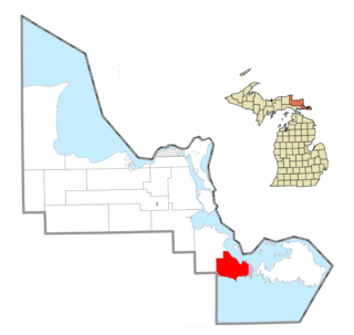
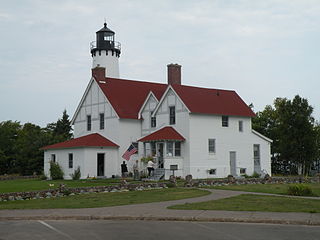
DeTour Township is a civil township of Chippewa County in the U.S. state of Michigan. The population was 807 at the 2010 census. The township is at the extreme eastern tip of the Upper Peninsula.

<span class="mw-page-title-main">Pickford Township, Michigan</span> Civil township in Michigan, United States

Pickford Township is a civil township of Chippewa County in the U.S. state of Michigan. As of the 2010 census, the township population was 1,595.

<span class="mw-page-title-main">Soo Township, Michigan</span> Civil township in Michigan, United States

Soo Township is a civil township of Chippewa County in the U.S. state of Michigan. The population was 3,141 at the 2010 census.

<span class="mw-page-title-main">Sugar Island Township, Michigan</span> Civil township in Michigan, United States

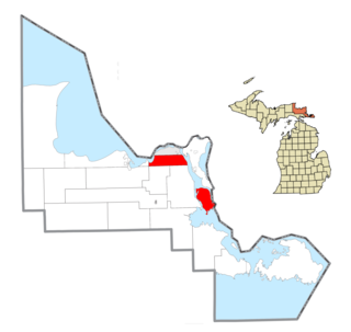
Sugar Island Township is a civil township of Chippewa County in the U.S. state of Michigan. The population was 653 at the 2020 census. The township consists of Sugar Island, several smaller islands, and the surrounding waters in the St. Marys River.

<span class="mw-page-title-main">Superior Township, Chippewa County, Michigan</span> Civil township in Michigan, United States

Superior Township is a civil township of Chippewa County in the U.S. state of Michigan. The population was 1,337 at the 2010 census.

<span class="mw-page-title-main">Nottawa Township, Isabella County, Michigan</span> Civil township in Michigan, United States

Nottawa Township is a civil township of Isabella County in the U.S. state of Michigan. The population was 2,225 at the 2020 census.

<span class="mw-page-title-main">Sherman Township, Isabella County, Michigan</span> Civil township in Michigan, United States

Sherman Township is a civil township of Isabella County in the U.S. state of Michigan. The population was 2,616 at the 2000 census.

Chippewa Township is a civil township of Mecosta County in the U.S. state of Michigan. As of the 2020 census, the township population was 1,227.

<span class="mw-page-title-main">Greendale Township, Michigan</span> Civil township in Michigan, United States

Greendale Township is a civil township of Midland County in the U.S. state of Michigan. As of the 2020 census, the township population was 1,731.

<span class="mw-page-title-main">Jasper Township, Michigan</span> Civil township in Michigan, United States

Jasper Township is a civil township of Midland County in the U.S. state of Michigan. The population was 1,060 at the 2020 census.

<span class="mw-page-title-main">Larkin Charter Township, Michigan</span> Charter township in Michigan, United States

Larkin Charter Township is a charter township of Midland County in the U.S. state of Michigan. The population was 5,331 at the 2020 census.

<span class="mw-page-title-main">Midland Township, Michigan</span> Charter township in Michigan, United States

Midland Charter Township is a charter township of Midland County in the U.S. state of Michigan. The population was 2,223 at the 2020 census. The township consists of three non-contiguous segments adjacent to the city of Midland, and the township and city are administered autonomously.

<span class="mw-page-title-main">Sanford, Michigan</span> Village in Michigan, United States

Sanford is a village in Midland County in the U.S. state of Michigan. The population was 813 at the 2020 census. The village is located within Jerome Township.

<span class="mw-page-title-main">Freeland, Michigan</span> Census-designated place & unincorporated community in Michigan, United States

Freeland is a census-designated place in Tittabawassee Township, Saginaw County in the U.S. state of Michigan. It is part of the Saginaw-Midland-Bay Metropolitan Area. As of the 2000 census, the CDP population was 5,147. The CDP covers an area in the central portion of Tittabawassee Township. The Freeland post office, ZIP code 48623, serves nearly the entire township, as well as portions of Midland and Williams townships to the north, Frankenlust and Kochville townships to the east, Thomas and Richland townships to the south, and Ingersoll Township to the west.

Nottawa Township is a civil township of St. Joseph County in the U.S. state of Michigan. The population was 3,999 at the 2000 census. The township is named after the Nottawaseppi Huron Band of Potawatomi.

References

  1. 1 2 "2023 U.S. Gazetteer Files: Michigan". United States Census Bureau. Retrieved October 18, 2023.
  2. 1 2 "P1. Race – Homer township, Michigan: 2020 DEC Redistricting Data (PL 94-171)". U.S. Census Bureau. Retrieved October 18, 2023.
  3. 1 2 "U.S. Census website". United States Census Bureau . Retrieved January 31, 2008.
  4. U.S. Geological Survey Geographic Names Information System: Homer Township, Midland County, Michigan
  5. "Decennial Census Official Publications". U.S. Census Bureau. Retrieved October 18, 2023.