Homer Township, Calhoun County, Michigan

Last updated

Homer Township, Michigan
USA Michigan location map.svg
Red pog.svg
Homer Township
Location within the state of Michigan
Coordinates: 42°7′41″N84°47′49″W / 42.12806°N 84.79694°W / 42.12806; -84.79694
Country United States
State Michigan
County Calhoun
Area
  Total36.2 sq mi (93.7 km2)
  Land35.7 sq mi (92.4 km2)
  Water0.5 sq mi (1.3 km2)
Elevation
991 ft (302 m)
Population
 (2020)
  Total2,896
Time zone UTC-5 (Eastern (EST))
  Summer (DST) UTC-4 (EDT)
ZIP code
49245
Area code 517
FIPS code 26-38940 [1]
GNIS feature ID1626485 [2]
Website homertownshipmi.us

Homer Township is a civil township of Calhoun County in the U.S. state of Michigan. It is part of the Battle Creek, Michigan Metropolitan Statistical Area. The population was 2,896 at the 2020 census. [3]

Contents

History

The first European settlers

The first permanent settlers were from Luzerne County, Pennsylvania. Powell Grover, William Wintersteen, Richard McMutrie, and Henry McMurtrie walked from Stroudsburg, Pennsylvania, arriving in the Homer area in April 1832. Powell Grover's group lived their first year in an abandoned log cabin located in Section 11 of present-day Homer Township, said to be the former residence of Potawatomi native Chief Ne-au-to-beer-saw, while the settlers built their own cabins. Grover also built a saw mill on the north bank of the Kalamazoo River in Section 11. The plains where Grover and his friends homesteaded was known as the Pennsylvania Settlement.

Milton Barney arrived from Lyons, New York, the summer of 1832 to scout the area and returned that September with his family and workmen to settle on the south bank of the Kalamazoo River in Section 5. Soon afterwards Barney hired Osha Wilder to layout the plat for the village of Barneyville on the southwest corner of Section 5, southeast corner of Section 6, northeast corner of Section 7, and northwest corner of Section 8. This was the beginning of the village of Homer.

In 1834, the territorial legislature divided the area into townships of 12-mile (19 km) squares 144 square miles (370 km2). The township in lower Calhoun County was named Homer due to the influence of James Hopkins and many other settlers from Homer, Cortland County, New York. This first township was later divided into the townships of Albion, Clarendon, Eckford, and Homer—each 6-mile (10 km) squares.

The Native Americans

According to Dr William Lane, the Potawatomi natives were friendly, and the children of settlers and natives often played together. Chief Ne-au-to-beer-saw, called "Leather-nose", [4] and Chief Wopkezike, lesser chiefs of the Baw Beese band of Potawatomi, are mentioned in many stories of the founding era. The native population was numerous until the U.S. government forcibly removed the Indians to reserves west of the Mississippi under authority of the Indian Removal Act and 1833 Treaty of Chicago. [5] Because of the peacefulness of the Potawatomi, they continued to co-exist with the settlers for many years after the Removal Act, until the autumn of 1840 when General Hugh Brady removed about 250 Indians of Hillsdale County and Homer to Miami County, Kansas, in reaction to homesteader complaints to the Van Buren administration. Chief Ne-au-to-beer-saw drowned while crossing the Detroit River returning from his escape to Canada. [6]

Communities

The village of Homer is within the township. The Homer ZIP code, 49245, serves the entire township as well as portions of Clarendon Township to the west, Eckford Township to the northwest and Albion Township to the north.

Geography

According to the United States Census Bureau, Homer Township has a total area of 36.2 square miles (93.7 km2), of which 35.7 square miles (92.4 km2) is land and 0.50 square miles (1.3 km2), or 1.44%, is water. [7]

Demographics

Historical population
CensusPop.Note
1960 2,614
1970 2,7143.8%
1980 3,04112.0%
1990 2,875−5.5%
2000 3,0104.7%
2010 3,0150.2%
2020 2,896−3.9%
Source: Census Bureau. Census 1960- 2000, 2010.

As of the census [1] of 2000, there were 3,010 people, 1,117 households, and 797 families residing in the township. The population density was 84.3 inhabitants per square mile (32.5/km2). There were 1,182 housing units at an average density of 33.1 per square mile (12.8/km2). The racial makeup of the township was 97.77% White, 0.20% African American, 0.10% Native American, 0.07% Asian, 0.10% from other races, and 1.76% from two or more races. Hispanic or Latino of any race were 1.69% of the population.

There were 1,117 households, out of which 37.6% had children under the age of 18 living with them, 52.9% were married couples living together, 12.1% had a female householder with no husband present, and 28.6% were non-families. 24.2% of all households were made up of individuals, and 11.5% had someone living alone who was 65 years of age or older. The average household size was 2.68 and the average family size was 3.18.

In the township the population was spread out, with 30.1% under the age of 18, 8.8% from 18 to 24, 28.2% from 25 to 44, 22.3% from 45 to 64, and 10.7% who were 65 years of age or older. The median age was 33 years. For every 100 females, there were 95.5 males. For every 100 females age 18 and over, there were 94.4 males.

The median income for a household in the township was $36,250, and the median income for a family was $42,159. Males had a median income of $31,649 versus $22,788 for females. The per capita income for the township was $16,686. About 9.5% of families and 14.6% of the population were below the poverty line, including 19.2% of those under age 18 and 17.4% of those age 65 or over.

Related Research Articles

<span class="mw-page-title-main">Calhoun County, Michigan</span> County in Michigan, United States

Calhoun County is a county in the U.S. state of Michigan. As of the 2020 Census, the population was 134,310. The county seat is Marshall. The county was established on October 19, 1829, and named after John C. Calhoun, who was at the time Vice President under Andrew Jackson, making it one of Michigan's Cabinet counties. County government was first organized on March 6, 1833. Calhoun County comprises the Battle Creek Metropolitan Statistical Area and is included in the Kalamazoo-Battle Creek-Portage Combined Statistical Area.

<span class="mw-page-title-main">Barry County, Michigan</span> County in Michigan, United States

Barry County is a county in the U.S. state of Michigan. As of the 2020 United States Census, the population was 62,423. The county seat is Hastings.

<span class="mw-page-title-main">Baroda Township, Michigan</span> Civil township in Michigan, United States

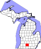
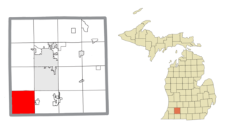
Baroda Township is a civil township of Berrien County in the U.S. state of Michigan. As of the 2020 census, the township population was 2,835.

<span class="mw-page-title-main">Weesaw Township, Michigan</span> Civil township in Michigan, United States

Weesaw Township is a civil township of Berrien County in the U.S. state of Michigan. The population was 1,832 at the 2020 census. The township was organized in 1837, and was named after Weesaw, a local Potawatomi chief.

Athens Township is a civil township of southwest Calhoun County in the U.S. state of Michigan, about 15 miles (24 km) south of Battle Creek. It is part of the Battle Creek, Michigan Metropolitan Statistical Area. As of the 2020 census, the township population was 2,444. The Nottawaseppi Huron Band of Potawatomi is based in Athens Township.

<span class="mw-page-title-main">Bedford Charter Township, Michigan</span> Charter township in Michigan, United States

Bedford Charter Township is a charter township located in the northwest corner of Calhoun County in the U.S. state of Michigan. It is part of the Battle Creek, Michigan Metropolitan Statistical Area. As of the 2020 census, the township population was 9,198. Most of the township lies north of the Kalamazoo River and the city of Battle Creek. Three small noncontiguous areas of the township lie south of the Kalamazoo River.

Clarence Township is a civil township located in northeast Calhoun County in the U.S. state of Michigan. It is part of the Battle Creek, Michigan Metropolitan Statistical Area. The population was 1,903 at the 2020 census. The township was originally named Pinkney Township.

Clarendon Township is a civil township of Calhoun County in the U.S. state of Michigan. The population was 1,181 at the 2020 census. The township is part of the Battle Creek Metropolitan Statistical Area.

Eckford Township is a civil township of Calhoun County in the U.S. state of Michigan. It is part of the Battle Creek Metropolitan Statistical Area. The population was 1,298 at the 2020 census. Eckford Township was named after Henry Eckford.

Fredonia Township is a civil township of Calhoun County in the U.S. state of Michigan located southwest of the city of Marshall. It is part of the Battle Creek Metropolitan Statistical Area. The population was 1,585 at the 2020 census.

<span class="mw-page-title-main">Homer, Michigan</span> Village in Michigan, United States

Homer is a village in Calhoun County in the U.S. state of Michigan. It is part of the Battle Creek, Michigan Metropolitan Statistical Area. The population was 1,575 at the 2020 census.

Leroy Township is a civil township of Calhoun County in the U.S. state of Michigan. It is part of the Battle Creek, Michigan Metropolitan Statistical Area. The population was 3,659 at the 2020 census.

Marshall Township is a civil township of Calhoun County in the U.S. state of Michigan. It is part of the Battle Creek, Michigan Metropolitan Statistical Area. The population was 3,157 at the 2020 census. The city of Marshall is adjacent to the township, but is administratively autonomous.

<span class="mw-page-title-main">Atlas Township, Michigan</span> Civil township in Michigan, United States

Atlas Township is a civil township of Genesee County in the U.S. state of Michigan. As of the 2020 census, the township population was 8,352, up from 7,993 at the 2010 census.

<span class="mw-page-title-main">Litchfield Township, Michigan</span> Civil township in Michigan, United States

Litchfield Township is a civil township of Hillsdale County in the U.S. state of Michigan. The population was 1,029 at the 2020 census.

<span class="mw-page-title-main">Prairie Ronde Township, Michigan</span> Civil township in Michigan, United States

Prairie Ronde Township is a civil township located in the southwestern corner of Kalamazoo County in the U.S. state of Michigan. The population was 2,250 at the 2010 census.

<span class="mw-page-title-main">Wakeshma Township, Michigan</span> Civil township in Michigan, United States

Wakeshma Township is a civil township of Kalamazoo County in the U.S. state of Michigan. The 2010 census recorded a population of 1,301, down from 1,414 at the 2000 census.

Pierson Township is a civil township of Montcalm County in the U.S. state of Michigan. The population was 3,363 at the 2020 census. The village of Pierson is located within the township.

<span class="mw-page-title-main">Almena Township, Michigan</span> Township in Michigan, United States

Almena Township is a civil township of Van Buren County in the U.S. state of Michigan. As of the 2020 census, the township population was 5,308.

<span class="mw-page-title-main">Mishicot, Wisconsin</span> Village in Wisconsin, United States

Mishicot is a village in Manitowoc County, Wisconsin, United States. The population was 1,442 at the 2010 census. The village is adjacent to the Town of Mishicot.

References

  1. 1 2 "U.S. Census website". United States Census Bureau . Retrieved January 31, 2008.
  2. U.S. Geological Survey Geographic Names Information System: Homer Township, Calhoun County, Michigan
  3. "Homer township, Calhoun County, Michigan - Census Bureau Profile". United States Census Bureau. Retrieved March 23, 2024.
  4. Michigan Historical Commission, "Letter of N.P. Hobart", Michigan Historical Collections, Vol. III Lansing: W.S. George and Company, 1881. p369
  5. Lane, William A, M.D., Homer and its Pioneers and its Business Men of To-day Homer, MI: P.W. Chase, 1888.
  6. Michigan Historical Commission, "Letter of N.P. Hobart", Michigan Historical Collections, Vol. III Lansing: W.S. George and Company, 1881. pp368-370
  7. "Geographic Identifiers: 2010 Demographic Profile Data (G001): Homer township, Calhoun County, Michigan". U.S. Census Bureau, American Factfinder. Archived from the original on February 12, 2020. Retrieved August 27, 2014.

Official Website