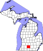
Athens Township is a civil township of southwest Calhoun County in the U.S. state of Michigan, about 15 miles (24 km) south of Battle Creek. It is part of the Battle Creek, Michigan Metropolitan Statistical Area. As of the 2020 census, the township population was 2,444. The Nottawaseppi Huron Band of Potawatomi is based in Athens Township.

The Potawatomi, also spelled Pottawatomi and Pottawatomie, are a Native American people of the Great Plains, upper Mississippi River, and western Great Lakes region. They traditionally speak the Potawatomi language, a member of the Algonquin family. The Potawatomi call themselves Neshnabé, a cognate of the word Anishinaabe. The Potawatomi are part of a long-term alliance, called the Council of Three Fires, with the Ojibway and Odawa (Ottawa). In the Council of Three Fires, the Potawatomi are considered the "youngest brother" and are referred to in this context as Bodéwadmi, a name that means "keepers of the fire" and refers to the council fire of three peoples.
The Odawa are an Indigenous American people who primarily inhabit land in the Eastern Woodlands region, now in jurisdictions of the northeastern United States and southeastern Canada. Their territory long preceded the creation of the current border between the two countries in the 18th and 19th centuries.

The Wyandotte Nation is a federally recognized Native American tribe headquartered in northeastern Oklahoma. They are descendants of the Wendat Confederacy and Native Americans with territory near Georgian Bay and Lake Huron. Under pressure from Haudenosaunee and other tribes, then from European settlers and the United States government, the tribe gradually moved south and west to Michigan, Ohio, Kansas, and finally Oklahoma in the United States.
The Menominee are a federally recognized tribe of Native Americans officially known as the Menominee Indian Tribe of Wisconsin. Their land base is the Menominee Indian Reservation in Wisconsin. Their historic territory originally included an estimated 10 million acres (40,000 km2) in present-day Wisconsin and the Upper Peninsula of Michigan. The tribe currently has about 8,700 members.

Citizen Potawatomi Nation is a federally recognized tribe of Potawatomi people located in Oklahoma. The Potawatomi are traditionally an Algonquian-speaking Eastern Woodlands tribe. They have 29,155 enrolled tribal members, of whom 10,312 live in the state of Oklahoma.

The Grand Traverse Band of Ottawa and Chippewa Indians is a federally recognized Native American tribe located in northwest Michigan on the Leelanau Peninsula. Sam McClellan is the current tribal chairman, elected in June 2016 to a four-year term after succeeding Al Pedwaydon, who served from 2012 to 2016.

The Treaty of Fort Meigs, also called the Treaty of the Maumee Rapids, formally titled, "Treaty with the Wyandots, etc., 1817", was the most significant Indian treaty by the United States in Ohio since the Treaty of Greenville in 1795. It resulted in cession by bands of several tribes of nearly all their remaining Indian lands in northwestern Ohio. It was the largest wholesale purchase by the United States of Indian land in the Ohio area. It was also the penultimate one; a small area below the St. Mary's River and north of the Greenville Treaty Line was ceded in the Treaty of St. Mary's in 1818.
Indigenous peoples of the Northeastern Woodlands include Native American tribes and First Nation bands residing in or originating from a cultural area encompassing the northeastern and Midwest United States and southeastern Canada. It is part of a broader grouping known as the Eastern Woodlands. The Northeastern Woodlands is divided into three major areas: the Coastal, Saint Lawrence Lowlands, and Great Lakes-Riverine zones.

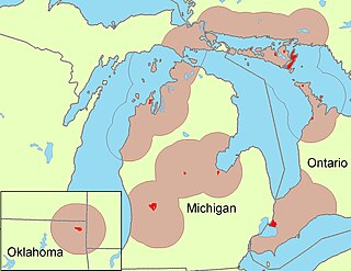
The Nottawaseppi Huron Band of Potawatomi (NHBP) is a federally-recognized tribe of Potawatomi in the United States. The tribe achieved federal recognition on December 19, 1995, and currently has approximately 1500 members.

Pokagon Band of Potawatomi Indians are a federally recognized Potawatomi-speaking tribe based in southwestern Michigan and northeastern Indiana. Tribal government functions are located in Dowagiac, Michigan. They occupy reservation lands in a total of ten counties in the area.

The Potawatomi Trail of Death was the forced removal by militia in 1838 of about 859 members of the Potawatomi nation from Indiana to reservation lands in what is now eastern Kansas.
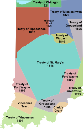
Indian removals in Indiana followed a series of the land cession treaties made between 1795 and 1846 that led to the removal of most of the native tribes from Indiana. Some of the removals occurred prior to 1830, but most took place between 1830 and 1846. The Lenape (Delaware), Piankashaw, Kickapoo, Wea, and Shawnee were removed in the 1820s and 1830s, but the Potawatomi and Miami removals in the 1830s and 1840s were more gradual and incomplete, and not all of Indiana's Native Americans voluntarily left the state. The most well-known resistance effort in Indiana was the forced removal of Chief Menominee and his Yellow River band of Potawatomi in what became known as the Potawatomi Trail of Death in 1838, in which 859 Potawatomi were removed to Kansas and at least forty died on the journey west. The Miami were the last to be removed from Indiana, but tribal leaders delayed the process until 1846. Many of the Miami were permitted to remain on land allotments guaranteed to them under the Treaty of St. Mary's (1818) and subsequent treaties.

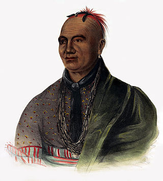
Menominee was a Potawatomi chief and religious leader whose village on reservation lands at Twin Lakes, 5 miles (8.0 km) southwest of Plymouth in present-day Marshall County, Indiana, became the gathering place for the Potawatomi who refused to remove from their Indiana reservation lands in 1838. Their primary settlements were at present day Myers Lake and Cook Lake. Although Menominee's name and mark appear on several land cession treaties, including the Treaty of St. Mary's (1818), the Treaty of Mississinewas (1826), the Treaty of Tippecanoe (1832), and a treaty signed on December 16, 1834, he and other Potawatomi refused to take part in subsequent land cession negotiations, including the Treaty of Yellow River (1836), that directly led to the forced removal of Menominee's band from Indiana in 1838.
Laura Spurr was the American chairwoman of the Nottawaseppi Huron Band of Potawatomi, a federally recognized Potawatomi tribe based in Calhoun County, Michigan, from 2003 until her death in 2010.
Nottawa Creek is a 33.9-mile-long (54.6 km) stream in the U.S. state of Michigan that flows into the St. Joseph River at 42°00′15″N85°23′40″W, approximately three miles east of the village of Mendon.
The Treaty of Detroit of 1855 was a treaty between the United States Government and the Ottawa and Chippewa Nations of Indians of Michigan. The treaty contained provisions to allot individual tracts of land to Native people consisting of 40-acre (16 ha) plots for single individuals and 80-acre (32 ha) plots for families, outlined specific tracts which were assigned to the various bands and provided for the severance of the government consolidation of the Ottawa and Chippewa.