Grove Hill, Alabama

Last updated

Grove Hill, Alabama
Town
Clarke County Courthouse.jpg
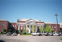
Clarke County Courthouse in Grove Hill
Clarke County Alabama Incorporated and Unincorporated areas Grove Hill Highlighted 0132080.svg
Location of Grove Hill in Clarke County, Alabama.
Coordinates: 31°42′22″N87°46′27″W / 31.70611°N 87.77417°W / 31.70611; -87.77417
CountryUnited States
State Alabama
County Clarke
Government
  TypeMayor/Council
  MayorRoss Wood
Area
[1]
  Total7.60 sq mi (19.68 km2)
  Land7.59 sq mi (19.66 km2)
  Water0.01 sq mi (0.02 km2)
Elevation
505 ft (154 m)
Population
 (2020)
  Total1,818
  Density239.53/sq mi (92.48/km2)
Time zone UTC-6 (Central (CST))
  Summer (DST) UTC-5 (CDT)
ZIP code
36451
Area code 251
FIPS code 01-32080
GNIS feature ID0155087
Website grovehillalabama.com

Grove Hill is a town in Clarke County, Alabama, United States. At the 2020 census, the population was 1,818. It is the county seat of Clarke County and home of the Clarke County Museum.

Contents

History

The area that is now Grove Hill was originally inhabited by Creek and Choctaw Indians. During the Creek War, settlers in the community sought protection in Fort White. [2] The county seat of Clarke County was established at what later became Grove Hill in 1832 as the spot was most central to the rest of the county. Known variously as Smithville, then Macon, the name Grove Hill was selected around 1850 for the large grove of oak trees on the plateau. The town was officially incorporated and chartered in 1929. [3] In 1853, a yellow fever epidemic struck the town, killing many residents, almost wiping out the town. [4]

The Grove Hill area has numerous sites on the National Register of Historic Places including the Alston-Cobb House, Bush House, John A. Coate House, Cobb House, Dickinson House, Fort Sinquefield, and the Grove Hill Courthouse Square Historic District. [5]

Geography

According to the U.S. Census Bureau, the town has a total area of 5.0 square miles (13 km2), all land. [6]

Climate

According to the Köppen climate classification, Grove Hill has a humid subtropical climate (abbreviated Cfa).

Climate data for Grove Hill, 1991–2020 simulated normals (505 ft elevation)
MonthJanFebMarAprMayJunJulAugSepOctNovDecYear
Mean daily maximum °F (°C)57.6
(14.2)
62.2
(16.8)
69.4
(20.8)
76.3
(24.6)
83.5
(28.6)
88.7
(31.5)
90.9
(32.7)
90.3
(32.4)
86.4
(30.2)
77.7
(25.4)
67.3
(19.6)
59.7
(15.4)
75.8
(24.3)
Daily mean °F (°C)46.9
(8.3)
51.1
(10.6)
57.7
(14.3)
64.6
(18.1)
72.7
(22.6)
79.0
(26.1)
81.1
(27.3)
80.4
(26.9)
76.1
(24.5)
66.7
(19.3)
56.1
(13.4)
49.1
(9.5)
65.1
(18.4)
Mean daily minimum °F (°C)36.5
(2.5)
40.1
(4.5)
46.2
(7.9)
53.1
(11.7)
61.7
(16.5)
69.1
(20.6)
71.4
(21.9)
70.5
(21.4)
65.8
(18.8)
55.9
(13.3)
44.8
(7.1)
38.7
(3.7)
54.5
(12.5)
Average precipitation inches (mm)5.60
(142.17)
5.14
(130.58)
5.56
(141.15)
4.35
(110.61)
4.10
(104.15)
5.73
(145.59)
6.45
(163.93)
5.14
(130.53)
4.45
(113.06)
3.59
(91.24)
4.39
(111.55)
5.82
(147.75)
60.32
(1,532.31)
Average dew point °F (°C)38.8
(3.8)
42.4
(5.8)
47.5
(8.6)
54.1
(12.3)
62.1
(16.7)
69.1
(20.6)
71.8
(22.1)
71.1
(21.7)
66.9
(19.4)
57.6
(14.2)
48.0
(8.9)
41.9
(5.5)
55.9
(13.3)
Source: Prism Climate Group [7]

Demographics

Historical population
CensusPop.Note
1870 200
1880 176−12.0%
1890 22527.8%
1930 491
1940 73048.7%
1950 1,44397.7%
1960 1,83427.1%
1970 1,825−0.5%
1980 1,9124.8%
1990 1,551−18.9%
2000 1,438−7.3%
2010 1,5709.2%
2020 1,81815.8%
U.S. Decennial Census [8]
2013 Estimate [9]

2020 census

Grove Hill Racial Composition [10]
RaceNum.Perc.
White 93851.6%
Black or African American 79043.45%
Native American 120.66%
Asian 130.72%
Other/Mixed 432.37%
Hispanic or Latino 221.21%

As of the 2020 United States Census, there were 1,818 people, 669 households, and 467 families residing in the town.

2010 census

As of the census [11] of 2010, there were 1,570 people, 615 households, and 402 families residing in the town. The racial makeup of the town was 56.6% White, 41.3% Black or African American, 0.3% Native American, 0.5% from other races, and 1.0% from two or more races. 2.0% of the population were Hispanic or Latino of any race.

There were 582 households, out of which 30.6% had children under the age of 18 living with them, 41.5% were married couples living together, 21.0% had a female householder with no husband present, and 34.6% were non-families. 31.9% of all households were made up of individuals, and 14.8% had someone living alone who was 65 years of age or older. The average household size was 2.36 and the average family size was 2.99.

In the town, the population was spread out, with 23.9% under the age of 18, 8.0% from 18 to 24, 26.0% from 25 to 44, 25.8% from 45 to 64, and 16.2% who were 65 years of age or older. The median age was 38.5 years. For every 100 females, there were 98.2 males. For every 100 females age 18 and over, there were 107.3 males.

Education

Public Education is provided by the Clarke County School System. Located in Grove Hill are Clarke County High School (grades 9 through 12), Wilson Hall Middle School (grades 5 through 8), and Grove Hill Elementary School (grades K though 4).

There is one private school in Grove Hill. Clarke Preparatory School provides education for grades K through 12.

Media

Radio station

WBMH 106.1 FM (Classic Country)

Notable people

Related Research Articles

<span class="mw-page-title-main">Clarke County, Alabama</span> County in Alabama, United States

Clarke County is a county located in the southwestern part of the U.S. state of Alabama. As of the 2020 census, the population was 23,087. The county seat is Grove Hill. The county's largest city is Jackson. The county was created by the legislature of the Mississippi Territory in 1812. It is named in honor of General John Clarke of Georgia, who was later elected governor of that state.

<span class="mw-page-title-main">Hale County, Alabama</span> County in Alabama, United States

Hale County is a county located in the west central portion of the U.S. state of Alabama. As of the 2020 census, the population was 14,785. Its county seat is Greensboro. It is named in honor of Confederate officer Stephen Fowler Hale.

<span class="mw-page-title-main">Tuscaloosa County, Alabama</span> County in Alabama, United States

Tuscaloosa County is a county in the northwest-central portion of the U.S. state of Alabama and is the center of commerce, education, industry, health care, and entertainment for the region.

<span class="mw-page-title-main">Billingsley, Alabama</span> Village in Alabama, United States

Billingsley is a village in Autauga County, Alabama, United States. At the 2020 census, the population was 125. It is part of the Montgomery Metropolitan Statistical Area.

<span class="mw-page-title-main">Centreville, Alabama</span> City in and county seat of Bibb County, Alabama

Centreville is a city in Bibb County, Alabama, United States. At the 2020 census, the population was 2,800. The city is the county seat of Bibb County.

<span class="mw-page-title-main">Vance, Alabama</span> Town in Alabama, United States

Vance is a town in Tuscaloosa and Bibb counties in the U.S. state of Alabama. As of the 2010 census it had a population of 1,529. It is most famous for the Mercedes-Benz U.S. International plant, currently the only one in North America. The current mayor of Vance is Brenda Morrison.

<span class="mw-page-title-main">West Blocton, Alabama</span> Town in Alabama, United States

West Blocton is a town in Bibb County, Alabama, United States. At the 2020 census, the population was 1,217. The current mayor is Daniel Sims.

<span class="mw-page-title-main">Butler, Alabama</span> City in and county seat of Choctaw County, Alabama

Butler is a town in and the county seat of Choctaw County, Alabama, United States. The population was 1,894 at the 2010 census.

<span class="mw-page-title-main">Heflin, Alabama</span> City in Alabama, United States

Heflin is a city and the county seat of Cleburne County, Alabama, United States. At the 2020 census, the population was 3,431. It is located approximately halfway between Birmingham and Atlanta along Interstate 20.

<span class="mw-page-title-main">Andalusia, Alabama</span> City in and county seat of Covington County, Alabama

Andalusia is a city in and the county seat of Covington County, Alabama, United States. At the 2020 census, the population was 8,805.

<span class="mw-page-title-main">Ozark, Alabama</span> City in Alabama, United States

Ozark is a city in and the county seat of Dale County, Alabama. As of the 2010 census, the population of the city was 14,907.

<span class="mw-page-title-main">Walnut Grove, Alabama</span> Town in Alabama, United States

Walnut Grove is a town in Etowah County, Alabama, United States. It is part of the Gadsden Metropolitan Statistical Area. At the 2010 census the population was 698. From 1880 until the 1960 U.S. Census, with the exclusion of 1890 when no figure was reported, Walnut Grove had the distinction of being the least populated community wholly within Etowah County. It lost that distinction in 1970 to newly incorporated Ridgeville which has held the title since.

<span class="mw-page-title-main">Greensboro, Alabama</span> City in Alabama, United States

Greensboro is a city in Hale County, Alabama, United States. At the 2010 census the population was 2,497, down from 2,731 at the 2000 census. The city is the county seat of Hale County, Alabama, which was not organized until 1867. It is part of the Tuscaloosa, Alabama Metropolitan Statistical Area.

<span class="mw-page-title-main">Moundville, Alabama</span> Town in Alabama, United States

Moundville is a town in Hale and Tuscaloosa counties in the U.S. state of Alabama. It was incorporated on December 22, 1908. From its incorporation until the 1970 census, it was wholly within Hale County. At the 2010 census the population was 2,427, up from 1,809 at the 2000 census. It is part of the Tuscaloosa Metropolitan Statistical Area. Within the town is Moundville Archaeological Site, the location of a prehistoric Mississippian culture political and ceremonial center.

<span class="mw-page-title-main">Dayton, Alabama</span> Town in Alabama, United States

Dayton is a town in Marengo County, Alabama, United States. The population was 28 at the 2020 census.

<span class="mw-page-title-main">Reform, Alabama</span> City in Alabama, United States

Reform is a city in Pickens County, Alabama, United States. At the 2010 census the population was 1,702, down from 1,978 in 2000. It is located approximately halfway between Columbus, Mississippi and Tuscaloosa on U.S. Route 82.

<span class="mw-page-title-main">Ashville, Alabama</span> City in and county seat of St. Clair County, Alabama

Ashville is a city in and one of the county seats of St. Clair County, Alabama, United States, other seat being Pell City. Its population was 2,212 at the 2010 census, down from 2,260, at which time it was a town. It incorporated in 1822.

<span class="mw-page-title-main">Brookwood, Alabama</span> City in Alabama, United States

Brookwood is a city in Tuscaloosa County, Alabama, United States. It incorporated in September 1977. As of the 2020 census, the population of the town is 2,504.

<span class="mw-page-title-main">Coker, Alabama</span> Town in Alabama, United States

Coker is a town in Tuscaloosa County, Alabama, United States. It incorporated in 1999. At the 2020 census, the population was 904. It is part of the Tuscaloosa, Alabama Metropolitan Statistical Area.

<span class="mw-page-title-main">Ridgway, Pennsylvania</span> Borough in Pennsylvania, United States

Ridgway is a borough in and the county seat of Elk County, Pennsylvania. As of the 2020 census it had a population of 4,039

References

  1. "2020 U.S. Gazetteer Files". United States Census Bureau. Retrieved October 29, 2021.
  2. Foscue, Virginia (1989). Place Names in Alabama. Tuscaloosa: The University of Alabama Press. p. 66. ISBN   0-8173-0410-X.
  3. "The Grove Hill Area Chamber of Commerce" . Retrieved January 15, 2010.
  4. Owen, Thomas McAdory; Marie Bankhead Owen (1921). History of Alabama and dictionary of Alabama biography, Volume 1. The S. J. Clarke Publishing Company. p. 716.
  5. "National Register Information System". National Register of Historic Places . National Park Service. April 15, 2008.
  6. "US Gazetteer files: 2010, 2000, and 1990". United States Census Bureau. February 12, 2011. Retrieved April 23, 2011.
  7. "PRISM Climate Group at Oregon State University". Northwest Alliance for Computational Science & Engineering (NACSE), based at Oregon State University. Retrieved March 14, 2023.
  8. "U.S. Decennial Census". Census.gov. Retrieved June 6, 2013.
  9. "Annual Estimates of the Resident Population: April 1, 2010 to July 1, 2013". Archived from the original on May 22, 2014. Retrieved June 3, 2014.
  10. "Explore Census Data". data.census.gov. Retrieved December 8, 2021.
  11. "U.S. Census website". United States Census Bureau . Retrieved January 31, 2008.
  12. "The Tuscaloosa News - Google News Archive Search". news.google.com.
  13. "Grant Gillis". Baseball-reference.com. Sports Reference LLC. Retrieved September 16, 2013.

31°42′22″N87°46′27″W / 31.706137°N 87.774274°W / 31.706137; -87.774274