Livingston, Alabama

Last updated

Livingston, Alabama
City of Livingston
SumterCountyAlabamaCourthouseLivingstonAlabama.jpg
The Sumter County Courthouse in Livingston, Alabama
Sumter County Alabama Incorporated and Unincorporated areas Livingston Highlighted 0143720.svg
Location of Livingston in Sumter County, Alabama.
Coordinates: 32°35′14″N88°11′17″W / 32.58722°N 88.18806°W / 32.58722; -88.18806
Country United States
State Alabama
County Sumter
Government
  MayorVacant [1]
Area
[2]
  Total7.21 sq mi (18.68 km2)
  Land7.13 sq mi (18.47 km2)
  Water0.08 sq mi (0.22 km2)
Elevation
154 ft (47 m)
Population
 (2020)
  Total3,436
  Density481.91/sq mi (186.07/km2)
Time zone UTC-6 (Central (CST))
  Summer (DST) UTC-5 (CDT)
ZIP code
35470
Area code(s) 205, 659
FIPS code 01-43720
GNIS feature ID0152129
Website https://www.cityoflivingstonal.com/

Livingston is a city in and the county seat of Sumter County, Alabama, United States [3] and the home of the University of West Alabama. By an act of the state legislature, it was incorporated on January 10, 1835.[ citation needed ] At the 2010 census the population was 3,485, up from 3,297 in 2000. It was named in honor of Edward Livingston, of the Livingston family of New York. [4]

Contents

Geography

Livingston is located at 32°35′14″N88°11′17″W / 32.58722°N 88.18806°W / 32.58722; -88.18806 (32.587332, -88.188161). [5]

According to the U.S. Census Bureau, the city has a total area of 7.2 square miles (19 km2), of which 7.1 square miles (18 km2) is land and 0.1 square miles (0.26 km2) (1.11%) is water.

Climate

Climate data for Livingston, Alabama, 1991–2020 normals, extremes 18912014
MonthJanFebMarAprMayJunJulAugSepOctNovDecYear
Record high °F (°C)91
(33)
89
(32)
90
(32)
95
(35)
99
(37)
105
(41)
106
(41)
106
(41)
103
(39)
99
(37)
88
(31)
90
(32)
106
(41)
Mean maximum °F (°C)74.5
(23.6)
78.6
(25.9)
84.0
(28.9)
86.9
(30.5)
91.3
(32.9)
96.0
(35.6)
98.1
(36.7)
97.6
(36.4)
94.4
(34.7)
89.0
(31.7)
82.1
(27.8)
76.2
(24.6)
99.7
(37.6)
Mean daily maximum °F (°C)57.4
(14.1)
62.7
(17.1)
70.3
(21.3)
77.0
(25.0)
83.6
(28.7)
89.3
(31.8)
91.5
(33.1)
92.0
(33.3)
86.9
(30.5)
78.2
(25.7)
66.7
(19.3)
59.4
(15.2)
76.3
(24.6)
Daily mean °F (°C)45.5
(7.5)
49.4
(9.7)
56.8
(13.8)
63.6
(17.6)
71.5
(21.9)
78.7
(25.9)
81.0
(27.2)
81.0
(27.2)
75.4
(24.1)
64.9
(18.3)
53.6
(12.0)
47.1
(8.4)
64.0
(17.8)
Mean daily minimum °F (°C)33.7
(0.9)
36.0
(2.2)
43.3
(6.3)
50.2
(10.1)
59.3
(15.2)
68.1
(20.1)
70.5
(21.4)
70.0
(21.1)
63.8
(17.7)
51.7
(10.9)
40.5
(4.7)
34.9
(1.6)
51.8
(11.0)
Mean minimum °F (°C)15.9
(−8.9)
20.1
(−6.6)
25.9
(−3.4)
33.8
(1.0)
43.5
(6.4)
56.2
(13.4)
63.4
(17.4)
61.6
(16.4)
48.8
(9.3)
34.0
(1.1)
25.4
(−3.7)
18.4
(−7.6)
12.5
(−10.8)
Record low °F (°C)−5
(−21)
5
(−15)
14
(−10)
24
(−4)
31
(−1)
42
(6)
51
(11)
52
(11)
35
(2)
24
(−4)
13
(−11)
2
(−17)
−5
(−21)
Average precipitation inches (mm)5.24
(133)
5.32
(135)
5.00
(127)
4.52
(115)
4.92
(125)
4.48
(114)
5.43
(138)
4.51
(115)
3.24
(82)
3.73
(95)
4.83
(123)
4.86
(123)
56.08
(1,425)
Average snowfall inches (cm)0.1
(0.25)
0.0
(0.0)
0.2
(0.51)
0.1
(0.25)
0.0
(0.0)
0.0
(0.0)
0.0
(0.0)
0.0
(0.0)
0.0
(0.0)
0.0
(0.0)
0.0
(0.0)
0.0
(0.0)
0.4
(1.01)
Average precipitation days (≥ 0.01 in)7.76.77.36.46.37.58.46.85.44.85.97.580.7
Average snowy days (≥ 0.1 in)0.10.00.00.10.00.00.00.00.00.00.00.00.2
Source 1: NOAA (precip/precip days, snow/snow days 19812010) [6] [7]
Source 2: National Weather Service (mean maxima/minima 19812010) [8]

Demographics

Historical population
CensusPop.Note
1870 500
1880 73847.6%
1890 85015.2%
1900 8510.1%
1910 8773.1%
1920 96810.4%
1930 1,07210.7%
1940 1,1709.1%
1950 1,68143.7%
1960 1,544−8.1%
1970 2,35852.7%
1980 3,18735.2%
1990 3,53010.8%
2000 3,297−6.6%
2010 3,4855.7%
2020 3,436−1.4%
U.S. Decennial Census [9]
2013 Estimate [10]

2020 census

Livingston Racial Composition [11]
RaceNum.Perc.
White 1,17634.23%
Black or African American 2,00958.47%
Native American 200.58%
Asian 962.79%
Pacific Islander 10.03%
Other/Mixed 561.63%
Hispanic or Latino 782.27%

As of the 2020 United States Census, there were 3,436 people, 1,211 households, and 592 families residing in the city.

2010 census

As of the 2010 United States Census, there were 3,485 people living in the city. 63.8% were African American, 34.4% White, 0.1% Native American, 0.3% Asian, <0.1% Pacific Islander and 0.6% of two more races. 0.7% were Hispanic or Latino of any race.

2000 census

As of the census [12] of 2000, there were 3,297 people, 1,368 households, and 731 families living in the city. The population density was 463.1 inhabitants per square mile (178.8/km2). There were 1,586 housing units at an average density of 222.8 per square mile (86.0/km2). The racial makeup of the city was 60.78% Black or African American, 37.82% White or Caucasian, 0.18% Asian, 0.15% Native American, 0.30% from other races, and 0.76% from two or more races. 1.43% of the population were Hispanic or Latino of any race.

Of the 1,368 households, 29.4% had children under the age of 18 living with them, 30.0% were married couples living together, 20.2% had a female householder with no husband present, and 46.5% were non-families. 35.5% of all households were made up of individuals, and 10.8% had someone living alone who was 65 years of age or older. The average household size was 2.31 and the average family size was 3.14.

In the city, the population was spread out, with 26.2% under the age of 18, 23.7% from 18 to 24, 24.2% from 25 to 44, 16.5% from 45 to 64, and 9.4% over the age of 65. The median age was 25 years. For every 100 females, there were 85.9 males. For every 100 females aged 18 and higher, there were 78.0 males.

The median income for a household in the city was $13,516, and the median income for a family was $22,500. Males had a median income of $31,838 as opposed to $20,833 for females. The per capita income for the city was $11,640. About 39.4% of families and 46.1% of the population were below the poverty line, including 53.4% of those under age 18 and 26.0% of those aged 65 years or more.

History

The area now known as Livingston was part of the traditional territory of the nation of Choctaw Indians until the Treaty of Dancing Rabbit Creek in 1830. The federal government removed most of the Choctaw to Indian Territory in present-day Oklahoma. At that time, settlers from the Carolinas, Georgia, Tennessee, and Virginia established the first European-American community about two blocks from the current Courthouse Square, near the corner of Madison and Spring Streets.

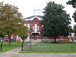
In 1833, a commission was formed to organize Sumter County. Livingston was named after a well-known statesman and jurist of the day, Edward Livingston. [4] Livingston was chosen as the county seat. Soon followed the first newspaper, The Voice of Sumter; four schools (including Livingston Female Academy, now The University of West Alabama), the courthouse, and the Bored Well.

The first courthouse was built of logs. It was replaced by a frame courthouse in 1839, which burned in 1901. The Probate Judge's office, built at the same time, survived the fire. It now houses the county commission office.

In the latter part of the nineteenth century, Livingston became widely known as a health spa because of the water from its Bored Well, one of many that made extensive settlement possible in the Black Belt. This well was bored by an old blind mule which pulled an auger around until an artesian aquifer was reached in 1857. Promoters built a Chinese-styled pagoda over the well. In 1924 the pagoda was replaced by the predecessor to the present pavilion.

During the early part of the twentieth century, Livingston continued to be known as a health resort. It was also the site of the Alabama Normal School, which developed from the Livingston Female Academy and was established to train teachers for the public school system founded during the Reconstruction era. Reflecting its expanding programs and level of curriculum, the name of the college was later changed to the State Teachers College, then to Livingston State College, Livingston University and finally to The University of West Alabama.

Livingston continued as the sleepy county seat of a mainly rural county, with a declining population. In the early 1960s, citizens made an effort to revitalize the town, building on their historic heritage and main street. The results were a near doubling in population in ten years, and corresponding increase in industry and businesses. In 1972 Livingston was named a finalist in the "All American Cities Competition", sponsored by The Saturday Evening Post.

Historic sites

Livingston has a number of historic sites and properties. Lakewood (1840) is a historic antebellum mansion occupied by Julia Tutwiler while she was president of Livingston Normal College. [13] The Sumter County Courthouse (1902) is listed on the National Register of Historic Places. [14] Additionally, the Branch-Stuart Home (1903), Inge-Moon House (1834), St. James Episcopal Church (1840), and Voss-Pate House (1850) are all listed on the Alabama Register of Landmarks and Heritage. [15]

Education

University of West Alabama is in Livingston.

Sumter County School District operates public schools serving Livingston: Livingston Junior High School and Sumter Central High School. It was previously served by Livingston High School until it merged into Sumter Central High in 2011. [16] In addition there is a charter school on the campus of the University of West Alabama in Livingston, University Charter School. [17]

Sumter Academy, a private school, was in an unincorporated area near York. [18] It closed in 2017. [19]

Notable people

Related Research Articles

<span class="mw-page-title-main">Greene County, Alabama</span> County in Alabama, United States

Greene County is a county located in the west central portion of the U.S. state of Alabama. As of the 2020 census, the population was 7,730, the least populous county in Alabama. Its county seat is Eutaw. It was named in honor of Revolutionary War General Nathanael Greene of Rhode Island.

<span class="mw-page-title-main">Marion County, Alabama</span> County in Alabama, United States

Marion County is a county of the U.S. state of Alabama. As of the 2020 census the population was 29,341. The county seat is Hamilton. The county was created by an act of the Alabama Territorial General Assembly on February 13, 1818. The county seat was originally established in Pikeville in 1820, and moved to Hamilton in 1881. The county was named by planter and US Indian agent John Dabney Terrell, Sr., in recognition of General Francis Marion of South Carolina.

<span class="mw-page-title-main">Sumter County, Alabama</span> County in Alabama, United States

Sumter County is a county located in the west central portion of Alabama. At the 2020 census, the population was 12,345. Its county seat is Livingston. Its name is in honor of General Thomas Sumter of South Carolina. The University of West Alabama is in Livingston.

<span class="mw-page-title-main">Lauderdale County, Mississippi</span> County in Mississippi, United States

Lauderdale County is a county located on the eastern border of the U.S. state of Mississippi. As of the 2020 census, the population was 72,984. The county seat is Meridian. The county is named for Colonel James Lauderdale, who was killed at the Battle of New Orleans in the War of 1812. Lauderdale County is included in the Meridian, MS Micropolitan Statistical Area.

<span class="mw-page-title-main">Union Springs, Alabama</span> City in Alabama, United States

Union Springs is a city in and county seat of Bullock County, Alabama, United States. The population was 3,980 at the 2010 census.

<span class="mw-page-title-main">Greensboro, Alabama</span> City in Alabama, United States

Greensboro is a city in Hale County, Alabama, United States. At the 2010 census the population was 2,497, down from 2,731 at the 2000 census. The city is the county seat of Hale County, Alabama, which was not organized until 1867. It is part of the Tuscaloosa, Alabama Metropolitan Statistical Area.

<span class="mw-page-title-main">Vernon, Alabama</span> City in Alabama, United States

Vernon is a city in Lamar County, Alabama, United States. The city is the county seat of Lamar County, and previously served as the seat of its two predecessors, Jones County, which briefly existed in 1867, and for Sanford County from 1868 until it was renamed Lamar in 1877. It incorporated in 1870. At the 2010 census the population was 2,000, down from 2,143 in 2000. It is the largest city in Lamar County as of 2010, and previously held the distinction in 1880 and from 1960 to 1990, falling to 2nd place in 2000 behind Sulligent, but since reclaiming the title.

<span class="mw-page-title-main">Linden, Alabama</span> City in Alabama, United States

Linden is a city in and the county seat of Marengo County, Alabama, United States. The population was 1,930 at the 2020 census, down from 2,123 at the 2010 census.

<span class="mw-page-title-main">Columbiana, Alabama</span> City in and county seat of Shelby County, Alabama

Columbiana is a city and the county seat of Shelby County, Alabama, United States. At the 2020 census, the population was 4,462.

<span class="mw-page-title-main">Ashville, Alabama</span> City in and county seat of St. Clair County, Alabama

Ashville is a city in and one of the county seats of St. Clair County, Alabama, United States, other seat being Pell City. Its population was 2,212 at the 2010 census, down from 2,260, at which time it was a town. It incorporated in 1822.

<span class="mw-page-title-main">Cuba, Alabama</span> Town in Alabama, United States

Cuba is a town in Sumter County, Alabama, United States. At the 2020 census the population was 306, down from 346 in 2010.

<span class="mw-page-title-main">Epes, Alabama</span> Town in Alabama U.S.

Epes is a town in Sumter County, Alabama, United States. Initially called Epes Station, it was incorporated as Epes in 1899. At the 2010 census the population was 192, down from 206 in 2000.

<span class="mw-page-title-main">Gainesville, Alabama</span> Town in Alabama, United States

Gainesville is a town in Sumter County, Alabama, United States. Founded in 1832, it was incorporated in 1835. At the 2010 census the population was 208, down from 220. Confederate Lieutenant General Nathan Bedford Forrest surrendered his men near Gainesville on May 19, 1865, at the Civil War's end.

<span class="mw-page-title-main">York, Alabama</span> City in Alabama, United States

York is a city in Sumter County, Alabama, United States. Founded around 1838 after the merging of two communities, Old Anvil and New York Station, the latter a station on a stagecoach line. The rail came through in the 1850s and later, the "New" was dropped from York Station in 1861. With the discovery that another community in Alabama bore that name, the "Station" was dropped and York was formally incorporated on April 6, 1881. At the 2010 census the population was 2,538, down from 2,854 in 2000. From 1920 to 1980, it was the largest town in the county. Since 1990, it has been the second largest city behind the county seat of Livingston.

<span class="mw-page-title-main">Camp Hill, Alabama</span> Town in Alabama, United States

Camp Hill is a town in Tallapoosa County, Alabama, United States. It was incorporated in 1895. At the 2010 census the population was 1,014, down from 1,273 in 2000. Camp Hill is the home to Southern Preparatory Academy.

<span class="mw-page-title-main">Camden, Alabama</span> City in and county seat of Wilcox County, Alabama

Camden is a city in and the county seat of Wilcox County, Alabama, United States. The population was 2,020 at the 2010 census, down from 2,257 in 2000, at which time it was a town.

<span class="mw-page-title-main">Marion, Kentucky</span> City in Kentucky, United States

Marion is a home rule-class city in Crittenden County, Kentucky, in the United States. It is the seat of its county. As of the 2010 census, the city population was 3,039.

<span class="mw-page-title-main">Cresaptown-Bel Air, Maryland</span> Former census-designated place in Maryland, United States

Cresaptown-Bel Air was a census-designated place in Allegany County, Maryland, United States. The population was 5,884 at the 2000 census. For the 2010 census, the area was separated into two CDPs, Cresaptown and Bel Air.

<span class="mw-page-title-main">Lovington, New Mexico</span> City in New Mexico, United States

Lovington is a city in, and the county seat of, Lea County, New Mexico, United States. The population was 11,009 at the 2010 census, up from 9,471 in 2000.

<span class="mw-page-title-main">Martin, Tennessee</span> City in Tennessee, United States

Martin is a city in Weakley County, Tennessee, United States. The population was 10,825 according to the 2020 census. The city is the home of the University of Tennessee at Martin.

References

  1. Sharp, John (February 24, 2024). "'Glue that held Livingston together': Thomas Tartt, Alabama town's mayor since 1980, dies at 69". AL.com. Retrieved February 25, 2024.
  2. "2020 U.S. Gazetteer Files". United States Census Bureau. Retrieved October 29, 2021.
  3. "Find a County". National Association of Counties. Retrieved June 7, 2011.
  4. 1 2 "History". City of Livingston. Archived from the original on September 1, 2012. Retrieved September 27, 2012.
  5. "US Gazetteer files: 2010, 2000, and 1990". United States Census Bureau. February 12, 2011. Retrieved April 23, 2011.
  6. "U.S. Climate Normals Quick Access – Station: Livingston, AL (19912020)". National Oceanic and Atmospheric Administration. Retrieved March 4, 2023.
  7. "U.S. Climate Normals Quick Access – Station: Livingston, AL (19812010)". National Oceanic and Atmospheric Administration. Retrieved March 4, 2023.
  8. "NOAA Online Weather Data – NWS Birmingham". National Weather Service. Retrieved March 4, 2023.
  9. "U.S. Decennial Census". Census.gov. Retrieved June 6, 2013.
  10. "Annual Estimates of the Resident Population: April 1, 2010 to July 1, 2013". Archived from the original on May 22, 2014. Retrieved June 3, 2014.
  11. "Explore Census Data". data.census.gov. Retrieved December 8, 2021.
  12. "U.S. Census website". United States Census Bureau . Retrieved January 31, 2008.
  13. Gamble, Robert (1987). The Alabama Catalog: A Guide to the Early Architecture of the State. University, AL: University of Alabama Press. p. 343. ISBN   0-8173-0148-8.
  14. "National Register Information System". National Register of Historic Places . National Park Service. April 15, 2008.
  15. "The Alabama Register of Landmarks & Heritage". preserveala.org. Alabama Historical Commission. April 4, 2012. Archived from the original (PDF) on May 10, 2012. Retrieved April 30, 2012.
  16. Williams, Andrea (August 9, 2011). "Students Attend First Day at Sumter Central High". WTOK. Archived from the original on January 15, 2019. Retrieved January 15, 2019.
  17. "About." University Charter School. Retrieved on January 15, 2019.
  18. Home. Sumter Academy. Retrieved on January 15, 2019. "181 Sumter Academy Road York, Alabama 36925"
  19. Taylor, Drew (June 21, 2017). "Sumter Academy shuts down following dwindling enrollment". Tuscaloosa News . Retrieved January 13, 2018.

32°35′14″N88°11′17″W / 32.587332°N 88.188161°W / 32.587332; -88.188161