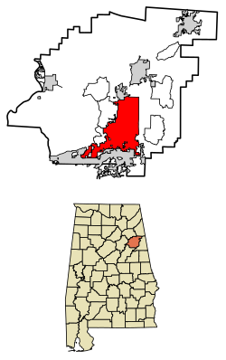
Anniston is the county seat of Calhoun County in Alabama, United States, and is one of two urban centers/principal cities of and included in the Anniston-Oxford Metropolitan Statistical Area. As of the 2010 census, the population of the city was 23,106.[2] According to 2019 Census estimates, the city had a population of 21,287.[3] Named "The Model City" by Atlanta newspaperman Henry W. Grady for its careful planning in the late 19th century, the city is situated on the slope of Blue Mountain.
Though the surrounding area was settled much earlier, the mineral resources in the area of Anniston were not exploited until the Civil War. The Confederate States of America operated an iron furnace near present-day downtown Anniston,[4] until it was destroyed by raiding Unioncavalry in early 1865. Later, cast iron for sewer systems became the focus of Anniston's industrial output. Cast iron pipe, also called soil pipe, was popular until the advent of plastic pipe in the 1960s.[5]
Woodstock Iron Company
1887 mapChild laborers at Anniston Yarn Mills, 1910. Photo by Lewis Hine.
In 1872, the Woodstock Iron Company, organized by Samuel Noble and Union Gen. Daniel Tyler, rebuilt the furnace on a much larger scale,[6] and started a planned community named Woodstock, soon renamed "Annie's Town" for Annie Scott Tyler, Daniel's daughter-in-law and wife of railroad president Alfred L. Tyler. Anniston was chartered as a town in 1873.[7]
Though the roots of the town's economy were in iron, steel, and clay pipe, planners touted it as a health resort, and several hotels began operating. Schools also appeared, including the Noble Institute, a school for girls established in 1886,[8] and the Alabama Presbyterian College for Men, founded in 1905.[6] Careful planning and easy access to rail transportation helped grow Anniston. In 1882, Anniston was the first city in Alabama to be lit by electricity.[9] By 1941, Anniston was Alabama's fifth largest city.[10]
World War I and II
In 1917, at the start of World War I, the United States Army established a training camp at Fort McClellan. On the other side of town, the Anniston Army Depot opened during World War II as a major weapons storage and maintenance site, a role it continues to serve as munitions-incineration progresses. Most of the site of Fort McClellan was incorporated into Anniston in the late 1990s, and the Army closed the fort in 1999 following the Base Realignment and Closure round of 1995.
Historic marker commemorating the Freedom Riders in downtown Anniston
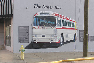
Anniston was the center of national controversy in 1961 when a mob bombed a bus filled with civilian Freedom Riders during the American Civil Rights Movement. As two Freedom buses were setting out to travel the south in protest of their civil rights following the Supreme Court case saying bus segregation was unconstitutional, one headed to Anniston, and one to Birmingham, Alabama, before finishing in New Orleans. The Freedom Riders were riding an integrated bus to protest Alabama's Jim Crowsegregation laws that denied African Americans their civil rights. One of the buses was attacked and firebombed by a mob outside Anniston on Mother's Day, Sunday, May 14, 1961. Prior to the bus being firebombed, attackers broke windows, and slashed tires, using metal pipes, clubs, chains and crowbars, before the police came to escort the bus away.[11] The bus was forced to a stop just outside of Anniston, in front of Forsyth and Sons grocery, by more mob members.[12] As more windows were broken, rocks and eventually a firebomb were thrown into the bus. As the bus burned, the mob held the doors shut, intent on burning the riders to death. An exploding fuel tank caused the mob to retreat, allowing the riders to escape the bus. The riders were viciously beaten as they tried to flee, where warning shots fired into the air by highway patrolmen prevented the riders from being lynched on the spot.[11] A 12-year-old girl, Janie Forsyth, set out against the mob with a bucket of water and cups to help the Riders, first tending to the one who had looked like her own nanny.[13] Forsyth and Son grocery is located along Alabama Highway 202 about 5 miles (8km) west of downtown. The site today is home to a historic marker and was designated Freedom Riders National Monument by President Barack Obama in January 2017.[14][15]
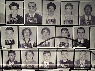
In response to the violence, the city formed a bi-racial Human Relations Council (HRC) made up of prominent white business and religious leaders, but when they attempted to integrate the "whites-only" public library on Sunday afternoon, September 15, 1963 (the same day as the 16th Street Baptist Church bombing in Birmingham), further violence ensued and two black ministers, N.Q. Reynolds and Bob McClain, were severely beaten by a mob. The HRC chairman, white Presbyterian minister Rev. Phil Noble, worked with an elder of his church, Anniston City Commissioner Miller Sproull, to avoid KKK mob domination of the city. In a telephone conference with President John F. Kennedy, the President informed the HRC that after the Birmingham church bombing he had stationed additional federal troops at Fort McClellan. On September 16, 1963, with city police present, Noble and Sproull escorted black ministers into the library.[16] In February 1964, Anniston Hardware, owned by the Sproull family, was bombed, presumably in retaliation for Commissioner Sproull's integration efforts.
On the night of July 15, 1965, a white racist rally was held in Anniston, after which Willie Brewster, a black foundry worker, was shot and killed while driving home from work. A $20,000 reward was raised by Anniston civic leaders, and resulted in the apprehension, trial and conviction of the accused killer, Damon Strange, who worked for a leader of the Ku Klux Klan.[17] Historian Taylor Branch called the conviction of Damon Strange a "breakthrough verdict" on p.391 of his Pulitzer Prize-winning book, At Canaan's Edge. Strange was convicted by an all-white Calhoun County jury to the surprise of many people, including civil rights leaders who had planned to protest an acquittal. This was the first conviction of a white person for killing a black person in civil rights era Alabama.[18]
PCB contamination
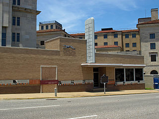
PCBs were produced in Anniston from 1929 to 1935 by the Swann Chemical Company. In 1935 Monsanto Industrial Chemicals Co. bought the plant and took over production, which continued until 1971. In 1969, the plant was discharging about 250 pounds (110kg) of the chemicals into Snow Creek per day, according to internal company documents.[19]
In 2002, an investigation by 60 Minutes[20] revealed Anniston had been among the most toxic cities in the country. The primary source of local contamination was a Monsanto chemical factory, which had already been closed. The EPA description[21] of the site reads in part:
The Anniston PCB site consists of residential, commercial, and public properties located in and around Anniston, Calhoun County, Alabama, that contain or may contain hazardous substances, including polychlorinated biphenyl (PCB) impacted media. The Site is not listed on the NPL, but is considered to be a NPL-caliber site.
According to the U.S. Census Bureau, the city has a total area of 45.7 square miles (118.4km2), of which 45.6 square miles (118.2km2) is land and 0.08 square miles (0.2km2), or 0.15%, is water.[2]
In 2003, part of the town of Blue Mountain was annexed into the city of Anniston, while the remaining portion of the town reverted to unincorporated Calhoun County.[22]
Part of the city limits extend down to Interstate 20, with access from exit 188. Via I-20, Birmingham is 65mi (105km) west, and Atlanta is 91mi (146km) east.
Climate
The climate in this area is characterized by hot, humid summers and generally mild to cool winters. According to the Köppen Climate Classification system, Anniston has a humid subtropical climate, abbreviated "Cfa" on climate maps.[23]
Climate data for Anniston, Alabama (Anniston Regional Airport) 1991–2020 normals, extremes 1903–present
As of the 2020 United States census, there were 21,564 people, 9,277 households, and 5,455 families residing in the city.
2010 Census data
As of the census of 2010, there were 23,106 people living in the city. The population density was 506.3 inhabitants per square mile (195.5/km2). There were 11,599 housing units at an average density of 281.5 per square mile (108.7/km2). The racial makeup of the city was 51.5% Black or African American, 43.6% Non-Hispanic White, 0.3% Native American, 0.8% Asian, 0.1% Pacific Islander, and 1.7% from two or more races. 2.7% of the population were Hispanic or Latino of any race.
There were 9,603 households, out of which 20.3% had children under the age of 18 living with them, 40.0% were married couples living together, 21.0% had a female householder with no husband present, and 38.6% were non-families. 34.8% of all households were made up of individuals, and 15.6% had someone living alone who was 65 years of age or older. The average household size was 2.26 and the average family size was 2.91.
In the city, the age distribution of the population shows 21.7% under the age of 18, 8.7% from 18 to 24, 25.7% from 25 to 44, 23.3% from 45 to 64, and 17.7% who were 65 years of age or older. The median age was 39 years. For every 100 females, there were 83.9 males. For every 100 females age 18 and over, there were 78.5 males.
The median income for a household in the city was $30,400, and the median income for a family was $37,067. Males had a median income of $31,429 versus $21,614 for females. The per capita income for the city was $19,689. About 25.1% of families and 29.8% of the population were below the poverty line, including 35.2% of those under age 18 and 16.2% of those age 65 or over.
Anniston Beat (Precinct) (Calhoun County 15th Beat) first appeared on the 1880 U.S. Census. In 1890, "beat" was changed to "precinct." In 1960, the precinct was changed to "census division" as part of a general reorganization of counties.[31] In 1980, three additional census divisions were consolidated into Anniston, including Oxford, Weaver and West End.[32]
In 1899, the county seat of Calhoun County moved from Jacksonville to Anniston. More than 100 years later, the community is a bustling center of industry and commerce with more than 22,000 residents. Over the years, city officials and local citizens have worked to retain the environmental beauty of the area while allowing it to thrive economically and to preserve its history. The Spirit of Anniston Main Street Program, Inc., a nonprofit organization started in 1993, spearheaded the restoration and revitalization of historic downtown Anniston, with a focus on the city's main thoroughfare, Noble Street.
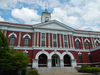
The Noble Streetscape Project encouraged local business owners to refurbish storefront façades, while historic homes throughout the downtown area have been repaired and returned to their former condition. The preservation effort included the historic Calhoun County Courthouse, located on the corner of 11th Street and Gurnee Avenue since 1900. The original building burned down in 1931, but the courthouse was rebuilt a year later. Thanks to a complete restoration in 1990, the stately structure is still in use today.
Anniston has long been a cultural center for northeastern Alabama. The Alabama Shakespeare Festival was founded in the city in 1972 and remained there until moving to Montgomery in 1985 seeking more robust financial support. The Knox Concert Series produces an annual season of world-renowned musical and dance productions, and the Community Actors' Studio Theatre community theatre organization performs plays, musicals, and revues featuring local performers, actors, and musicians. CAST also features specially funded programs to educate area children in the arts for free. The city is home to the Anniston Museum of Natural History and the Berman Museum of World History. These institutions house mummies, dioramas of wildlife, and artifacts from a bygone age in contemporary, professional displays and exhibits. The Alabama Symphony Orchestra since 2004 has performed a summer series of outdoor concerts, Music at McClellan, at the former Fort McClellan.
The city has many examples of Victorian-style homes, some of which have been restored or preserved. Several of the city's churches are architecturally significant or historic, including the Church of St. Michael and All Angels, Grace Episcopal Church, Parker Memorial Baptist Church, and the Mount Zion Missionary Baptist Church, a predominantly African-American church in what is known as the Zion Hill community. Temple Beth El, dedicated in 1893, is the oldest building in the state continuously used for Jewish worship.
The original main street, Noble Street, is seeing a rebirth as a shopping and dining district in the heart of downtown.
Anniston was featured in the fifteenth episode of the Small Town News Podcast, an improv comedy podcast that takes listeners on a fun and silly virtual trip to a small town in America each week, in which the hosts improvise scenes inspired by local newspaper stories.[34]
Fort McClellan
Fort McClellan—former site of the U.S. Army Military Police Training Academy, a Vietnam era Infantry Training Center, Chemical Corps Regimental Headquarters, Chemical Warfare training center, and Women's Army Corps Headquarters—was decommissioned in the 1990s. A portion of the former fort is now home to the Alabama National Guard Training Center. Another 9,000 acres (36km2) of the fort were set aside for the Mountain Longleaf National Wildlife Refuge in 2003. The Department of Homeland Security also uses a portion of the decommissioned fort for the Center for Domestic Preparedness, the nation's only civilian "live agent" training center; emergency response providers from all over the world come to Fort McClellan to be trained in dealing with live agents and weapons in a real-time, monitored setting.[citation needed]
Government
Anniston is governed by Alabama's "weak mayor" form of city government. Four city council members are elected to represent the city's four wards, and the mayor is elected at-large. Day-to-day functions of city government are carried out by the city manager, who is appointed by the mayor and city council.
The current five-member city council are Jack Draper (mayor), Jay Jenkins (Ward 1), D.D. Roberts (Ward 2), Ciara Smith (Ward 3 and vice-mayor), and Millie Harris (Ward 4).[35]
Anniston is the county seat of Calhoun County, Alabama. Circuit and district courts for the county and the district attorney's office are located in the Calhoun County Courthouse at the corner of 11th Street and Gurnee Avenue. Other county administrative offices are in the Calhoun County Administrative Building at the corner of 17th and Noble streets, and a United States Courthouse, part of the U.S. Alabama Northern District Court, is located at the corner of 12th and Noble streets.
Statewide testing ranks the schools in Alabama. Those in the bottom six percent are listed as "failing". As of early 2018, Anniston High School was included in this category.[36]
The school system boasts one of the most high-tech computing capabilities in the state,[quantify] according to representatives from Huntsville as well as various news agencies [weaselwords]. Every school is equipped with labs featuring Mac computers, 55-inch (1,397mm) plasma displays, and interactive whiteboards. Some schools have more computer labs, and Anniston High School also has an ACCESS Lab that allows for videoconferencing based classes involving other schools, supported by a high speed fiber network.[quantify]
A public four-year institution of higher learning, Jacksonville State University, is located 12 miles (19km) to the north in Jacksonville. Anniston is home to some satellite campuses of Gadsden State Community College, both at the former Fort McClellan and at the Ayers campus in southern Anniston.
There are several private primary and secondary schools in Anniston, including:
Anniston is served by two daily newspapers: The Birmingham News statewide edition, and the local 25,000 circulation daily paper, The Anniston Star. Anniston-based Consolidated Publishing Co., publisher of The Anniston Star, also owns and operates advertising-supported newspapers in nearby Jacksonville, Piedmont and Cleburne County. Local radio stations include WHMA AM and FM and WHOG 1120 AM.
WEAC-CD is the only television station that directly broadcasts from the Anniston area, but many Birmingham stations have towers and news bureaus here, such as WJSU-TV (WJSU is a local broadcast station for Birmingham-based ABC 33/40), WBRC-TV (Fox), and WVTM-TV (NBC). Alabama Public Television erected its tallest tower atop Cheaha Mountain12 miles (19km) south of Anniston. WJSU-TV 40 was historically a local CBS affiliate, broadcasting local newscasts daily.
Formerly its own Arbitron-defined broadcast market, today Anniston is a part of the Birmingham-Anniston-Tuscaloosa television designated market area. Radio stations are divided into three sub markets within that market; Anniston is in the Anniston-Gadsden–Talladega radio sub market.
Infrastructure
Transportation
The following major highways pass through Anniston:
The Anniston Western Bypass runs from Interstate 20 in Oxford (the Coldwater exit) and runs north into the present State Route 202. It is five lanes wide, handling Anniston Army Depot traffic. Future plans will extend it on the present County Road 109 by widening it to connect with US 431. State Route 202 follows this route from CR 109 (Bynum-Leatherwood Road) southward.
The Anniston Eastern Bypass was a stalled project of the Alabama Department of Transportation to build a four-lane highway in Calhoun County until revived by the 2009 federal stimulus package.[46] It was the largest influx of federal money into the local economy since Fort McClellan closed. More than $21 million was earmarked for this project in 2005. This funding was spent acquiring rights of way and grading a section of the proposed bypass from Oxford to the community of Golden Springs. As of April 2009, the section was a graded, but undriveable, clay dirt road bed. The Eastern Bypass was revived by the 2009 Federal Stimulus Package and was opened to traffic into McClellan on the northwest end in January 2011. As of December 2015, the route is now open to traffic and carries US-431 from the Saks community southward.
Amtrak serves Anniston with its Crescent service, operating to and from New Orleans and New York.[47] Southbound trains depart at 10:30am, and northbound trains depart at 6:59pm (central time).[48]
The Areawide Community Transportation System (ACTS) provides fixed-route bus and paratransit services within Anniston and Oxford. The service operates Monday through Friday from 6:00 AM to 6:00 PM and on Saturdays from 10:00 AM to 5:00 PM. There is no service on Sundays.
Anniston Army Depot
Anniston is home to the Anniston Army Depot which is used for the maintenance of most Army tracked vehicles. The depot also housed a major chemical weapons storage facility, the Anniston Chemical Activity, and a program to destroy those weapons, the Anniston Chemical Agent Disposal Facility. In 2003, the Anniston Army Depot began the process of destroying the chemical weapons it had stored at the depot and at Fort McClellan. An incinerator was built to destroy the stockpile of Sarin, VX nerve agent, and mustard blister agent stored at the depot. Destruction of the weapons was completed in 2011.[49] The incinerator and related operations were officially closed in May 2013, and the incinerator was disassembled and removed from the depot at the end of 2013.[49]
↑ Writer's Program. The WPA Guide to Alabama. New York: Hastings House, 1941. p. 159. Republished in 2013 by Trinity University Press, San Antonio, TX.
↑ "Station: Anniston Metro AP, AL". U.S. Climate Normals 2020: U.S. Monthly Climate Normals (1991-2020). National Oceanic and Atmospheric Administration. Retrieved June 7, 2021.
Grace Hooten Gates, The Model City of the New South: Anniston, Alabama, 1872–1900. Tuscaloosa, AL: University of Alabama Press, 1996.
Kimberly O'Dell, Anniston. Mount Pleasant, SC: Arcadia Publishing, 2000.
Ellen Griffith Spears, Baptized in PCBs: Race, Pollution, and Justice in an All-American Town. Chapel Hill, NC: University of North Carolina Press, 2013.
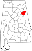
Calhoun County is a county in the east central part of the U.S. state of Alabama. As of the 2020 census, the population was 116,441. Its county seat is Anniston. It is named in honor of John C. Calhoun, a US Senator from South Carolina.
Oxford is a city in Calhoun, Talladega, and Cleburne counties in the State of Alabama, United States. The population was 22,069 at the 2020 census,. Oxford is one of two principal cities of and included in the Anniston-Oxford Metropolitan Statistical Area, and it is the largest city in Calhoun County by population.
Piedmont is a city in Calhoun and Cherokee counties in the U.S. state of Alabama. The population was 4,400 at the 2020 census. It is included in the Anniston-Oxford, Alabama Metropolitan Statistical Area.
Central Alabama is a region in the state of Alabama. It is sometimes considered part of North Alabama because both regions are mountainous, but in some definitions they are different regions.
Anniston Army Depot (ANAD) is a major United States Army facility for the production and repair of ground combat vehicles, overhaul of Small Arms Weapon Systems and the storage of chemical weapons, a.k.a. the Anniston Chemical Activity. The depot is located in Bynum, Alabama.
U.S. Route 431 (US 431), internally designated by the Alabama Department of Transportation (ALDOT) as State Route 1 (SR 1), is a major north–south state highway across the eastern part of the U.S. state of Alabama. Although US 431's south end is in Dothan, SR 1 continues south for about 13 miles (21 km) along US 231 to the Florida state line.
Fort McClellan, originally Camp McClellan, is a decommissioned United States Army post located adjacent to the city of Anniston, Alabama. During World War II, it was one of the largest U.S. Army installations, training an estimated half-million troops. After the war it became the home of the Military Police Corps, the Chemical Corps and the Women's Army Corps. From 1975 and until it was closed in 1999, Fort McClellan was home of the Military Police Corps and the One Station Unit Training (OSUT) Military Police School. Also after World War II and until it was closed in 1999, it was home of the Chemical Corps School, which trained soldiers in chemical warfare. In 1988, Fort McClellan was used as an alternate training academy for the United States Border Patrol. Before its closure by the Base Realignment and Closure commission (BRAC), the post employed about 10,000 military personnel and about 1,500 civilians. It underwent unexploded ordnance (UXO) clean up from 2003 to 2014. Since 2010, about 3,000 acres of the post's brownfield land have been redeveloped as a mixed-use community. The portion of the post which has not been redeveloped is currently owned by the Alabama Army National Guard and is used as a training facility for units from all across the state, also housing the Alabama Army National Guard’s Officer Candidate School, for enlisted soldiers looking to earn their commission.
The Anniston–Oxford metropolitan statistical area is the second-most populated metropolitan area in Northeast Alabama, behind Huntsville. At the 2000 census, it had a population of 112,249. The MSA is anchored by significant jobs at Jacksonville State University, the Northeast Alabama Regional Medical Center, Stringfellow Hospital, the Anniston Army Depot, and the Department of Homeland Security at McClellan. McClellan has transitioned from being a closed military base, to becoming the home of hundreds of residents, new retail growth such as a Lowe's Home Improvement Store, and now more than 3,000 jobs spread out over more than 20 employers. Anniston remains strong in health care, legal, financial services and manufacturing. Oxford, with Interstate 20 running right through it, has developed a number of retail and restaurant establishments including the Oxford Exchange which is anchored by Target.
State Route 202 is a 9.1-mile-long (14.6 km) route that serves as a connection between I-20 west of the Anniston/Oxford area and Anniston in Calhoun County.
The Center for Domestic Preparedness (CDP) is the only U.S. federal facility chartered to provide comprehensive preparedness training programs to the nation's emergency response providers. The facility, located in Calhoun County, Alabama, provides all-hazards training to approximately 50,000 emergency responders annually, or a total of 1.1 million responders since its inception in 1998. Trainees hail from state, local, tribal, territorial, and federal governments, as well as private entities. Training for state, local, tribal, and territorial governments are entirely funded by the United States Department of Homeland Security (DHS), whereas responders for foreign federal governments and private entities may be trained on a fee-for-service basis.
Joseph John Domnanovich was a professional American football center. He played six seasons in the National Football League (NFL) for the Boston Yanks (1946–1948) and the New York Bulldogs/Yanks (1949–1951). Prior to his professional career Domanovich played for Coach Frank Thomas at the University of Alabama from 1938–1942. He played both linebacker and center and became an All-American center at Alabama. He was voted to the All-time Alabama team for the first 50 years (1892–1942) in 1943. Between college and his pro career he served in the Third United States Army European Theater Special Services, from 1943 to 1946. He coached the line and played center for the 1945 Fort McClellan Riflemen football team.
Freedom Riders were civil rights activists who rode interstate buses into the segregated Southern United States in 1961 and subsequent years to challenge the non-enforcement of the United States Supreme Court decisions Morgan v. Virginia (1946) and Boynton v. Virginia (1960), which ruled that segregated public buses were unconstitutional. The Southern states had ignored the rulings and the federal government did nothing to enforce them. The first Freedom Ride left Washington, D.C., on May 4, 1961, and was scheduled to arrive in New Orleans on May 17.
The Freedom Rides Museum is located at 210 South Court Street in Montgomery, Alabama, in the building which was until 1995 the Montgomery Greyhound Bus Station. It was the site of a violent attack on participants in the 1961 Freedom Ride during the Civil Rights Movement. The May 1961 assaults, carried out by a mob of white protesters who confronted the civil rights activists, "shocked the nation and led the Kennedy Administration to side with civil rights protesters for the first time."
The Alabama Regional Communications System (ARCS) is a radio/alert notification communications district with responsibility for providing user-based administration for operations and maintenance of the interoperable communications system that serves Calhoun County, Alabama and Talladega County, Alabama. The Motorola trunked radio system is licensed by the Federal Communications Commission (FCC) to operate on radio frequency spectrum in the 800 megahertz (MHz) public safety band.
Fort McClellan Army Airfield is a closed military airfield located 6 mi (9.7 km) north-northeast of Anniston, Alabama, United States.
Mary Elizabeth Clarke was a United States Army officer who was the department head of the Women's Army Corps. She became major general in the United States Army and was the first woman to obtain this rank. She served in the United States Army for thirty six years, the longest ever served for a woman in the United States Army. In 1978 Norwich University awarded her an honorary doctorate in military science. She retired in 1981 and was on the Women in the Services Defense Advisory Committee.
The Freedom Riders National Monument is a United States National Monument in Anniston, Alabama established by President Barack Obama in January 2017 to preserve and commemorate the Freedom Riders during the Civil Rights Movement. The monument is administered by the National Park Service. The Freedom Riders National Monument is one of three National Monuments that was designated by presidential proclamation of President Obama on January 12, 2017. The second was the Birmingham Civil Rights National Monument and the third, the Reconstruction Era National Historical Park, was re-designated as a National Historical Park on March 12, 2019.
The Anniston and Birmingham bus attacks, which occurred on May 14, 1961, in Anniston and Birmingham, both Alabama, were acts of mob violence targeted against civil rights activists protesting against racial segregation in the Southern United States. They were carried out by members of the Ku Klux Klan and the National States' Rights Party in coordination with the Birmingham Police Department. The FBI did nothing to prevent the attacks despite having foreknowledge of the plans.
Robert E. Noble was an American physician and a career officer in the United States Army. A veteran of the Philippine–American War, United States occupation of Veracruz, World War I, and the Occupation of the Rhineland, he attained the rank of major general and was a recipient of the Army Distinguished Service Medal and French Legion of Honor (Commander).
This page is based on this Wikipedia article Text is available under the CC BY-SA 4.0 license; additional terms may apply. Images, videos and audio are available under their respective licenses.