Related Research Articles

Lake Paringa is a small lake 50 kilometres north of Haast on the West Coast of New Zealand's South Island.

The Clearwater River is on the West Coast of the South Island of New Zealand. The river originates on the northern slopes of Mt Mitchell on the eastern end of the Victoria Range, only one valley north of the Fox Glacier and Fox River. Clearwater River and its tributary creeks drain land to the north of the Cook (Weheka) River. The river flows under a bridge of SH 6 just north of the Fox Glacier township and passes close to Lake Matheson shortly after before flowing into Cook River, which drains into the Tasman Sea.

The Cook River / Weheka is in the South Island of New Zealand. The headwaters are from the La Perouse Glacier on the western flanks of the Southern Alps, and it flows west, then northeast, then northwest and into the Tasman Sea. Its tributaries include the Balfour River, fed by the Balfour Glacier, and the Fox River, fed by the Fox Glacier. Much of the river lies within the Westland Tai Poutini National Park. The river was renamed from Cook River to Cook River / Weheka as a result of the Ngai Tahu Claims Settlement Act 1998.

The Haast River / Awarua is a river on the West Coast of the South Island of New Zealand.

The Copland River is a river on the West Coast of the South Island of New Zealand. It flows for 20 kilometres (12 mi) from its headwaters in the Southern Alps to its confluence with the Karangarua River.

The Kawarau River is a river in the South Island of New Zealand. It drains Lake Wakatipu in northwestern Otago via the lake's Frankton Arm. The river flows generally eastwards for about 60 kilometres (37 mi) and passes through the steep Kawarau Gorge until it joins Lake Dunstan near Cromwell. Before the construction of the Clyde High Dam, the Kawarau joined the Clutha River / Mata-Au in a spectacular confluence at Cromwell. The Shotover River enters the Kawarau from the north; the Nevis River enters it from the south. With many rapids and strong currents, the river can be dangerous and has claimed many lives. It is popular for bungy jumping and kayaking.
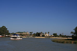
Renmark is a town in South Australia's rural Riverland area, and is located 254 km (157.83 mi) northeast of Adelaide, on the banks of the River Murray. The Sturt Highway between Adelaide and Sydney runs through the town; Renmark is the last major town encountered in South Australia when driving this route. It is 31 m (101.71 ft) above sea level. At the 2016 census, Renmark had a population of 4,634.

The Manuherikia River is located in Otago in the South Island of New Zealand. It rises in the far north of the Maniototo, with the West Branch draining the eastern side of the St Bathans Range, and the East Branch draining the western flanks of the Hawkdun Range. The river continues southwest through the wide Manuherikia Valley to its confluence with the Clutha River at Alexandra. During the 1860s the Manuherikia was one of the centres of the Central Otago Gold Rush.
The Coal River is a river of Fiordland, New Zealand. It rises south of Stephens Peak and flows south-westward into the Tasman Sea, draining Lakes Beattie, Swan and Paradise.
The Cust River is a river in the Canterbury region of New Zealand. It flows east across the upper Canterbury Plains from its source north of the town of Oxford, New Zealand, flowing into the Cam River / Ruataniwha close to the town of Rangiora. The small town of Cust lies on the banks of the river. The lower part of the river, to the south-west of Rangiora, is diverted into a channel and called the "Main Drain". The channel was built in 1862 to drain the swampy land between Rangiora and the Waimakariri River, and when it was enlarged in 1868 it accidentally captured the Cust.
The Douglas River, formerly known as the Twain, is a river of the West Coast of New Zealand's South Island. Its source is high in the Southern Alps, five kilometres (3.1 mi) south of Mount Sefton, and its upper reaches are fed by water from the Douglas Glacier. It flows west for 18 kilometres (11 mi), joined by runoff from the Horace Walker Glacier, before joining the waters of the Karangarua River. The Douglas River's entire course is within Westland Tai Poutini National Park. The river and glacier are named after Charles Edward Douglas, a 19th-century explorer and mountaineer.
The Gunn River is a river on the West Coast of New Zealand. It starts in the Price Range in Westland Tai Poutini National Park and flows east into the Whataroa River, which eventually drains into the Tasman Sea.
The Hapuka River is a river of Westland District, New Zealand. It flows from near The Woolsack north-west to join the Okuru and Turnbull Rivers just before they enter the Tasman Sea. The river is slow-moving and drains swampy land. There are brown trout in the lagoon area.
The Ōtoko River is a river of the West Coast Region of New Zealand's South Island. It flows generally northwest from the northern slopes of Mount Hooker, reaching the Paringa River 20 kilometres south of Bruce Bay.
The Paringa River is a river of the West Coast Region of New Zealand's South Island. It flows generally northwest from its origins in the Southern Alps southwest of Mount Hooker, reaching the Tasman Sea 10 kilometres southwest of Bruce Bay.
The Waita River is in the West Coast Region of New Zealand's South Island. It flows generally west to reach the Tasman Sea 10 kilometres northeast of the mouth of the Haast River. The river has its source on the western flanks of the Mataketake Range and passes through dense native forest which opens up into farm land before passing under the State Highway 6. The Maori River is one of the tributaries of the Waita.

The Fox River is a river in the Westland District of New Zealand. It arises in two places; from a spring in the Fox Range, and from the head of the Fox Glacier. It runs west into the Cook River/Weheka, shortly before it exits into the Tasman Sea.
Stokkavatnet is a former lake that was located at Forus in Stavanger, Norway, between the two fjords Hafrsfjord and Gandsfjord. The lake was among the largest at the Northern Jæren district, with an area of about 4 km2. It was surrounded by considerable areas of marsh land, and was known for a rich birdlife. The lake drained to Gandsfjord, and the outlet supplied six mills located near the fjord.

The Clarke River in Westland District is the southernmost of three rivers thus-named in the South Island of New Zealand. It is a major tributary of the Haast River, flowing southwest from its source on the slopes of Mount Hooker before joining with the Landsborough River three kilometres before the waters of both flow into the Haast at the point where the latter river turns west towards its outflow into the Tasman Sea.
Waiwera South is a small settlement in the South Island of New Zealand, close to the boundary between the Otago and Southland regions. The settlement is located between Balclutha and Clinton, immediately to the south of State Highway 1, between branches of the Waiwera River and Kaihiku Stream, two minor tributaries of the Clutha River. The South Island Main Trunk railway also runs through the township. The settlement's population is around 100.
References
- ↑ Transactions and Proceedings of the Royal Society of New Zealand 1868-1961. Vol. 71. 1942. p. 285. Retrieved 12 July 2009.
- ↑ Peter Dowling, ed. (2004). Reed New Zealand Atlas. Reed Books. p. map 78. ISBN 0-7900-0952-8.
- Land Information New Zealand - Search for Place Names
Coordinates: 43°41′47″S169°26′02″E / 43.69639°S 169.43389°E