
Aoraki / Mount Cook is the highest mountain in New Zealand. Its height, as of 2014, is listed as 3,724 metres. It sits in the Southern Alps, the mountain range that runs the length of the South Island. A popular tourist destination, it is also a favourite challenge for mountain climbers. Aoraki / Mount Cook consists of three summits: from south to north, the Low Peak, the Middle Peak and the High Peak. The summits lie slightly south and east of the main divide of the Southern Alps, with the Tasman Glacier to the east and the Hooker Glacier to the southwest.
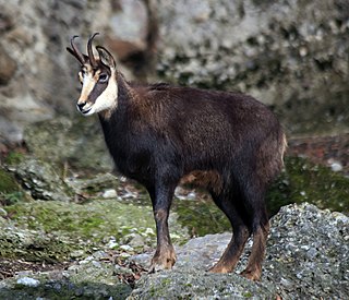
The chamois or Alpine chamois is a species of goat-antelope native to mountains in Europe, from west to east, including the Pyrenees, the Alps, the Apennines, the Dinarides, the Tatra and the Carpathian Mountains, the Balkan Mountains, the Rila–Rhodope massif, Pindus, the northeastern mountains of Turkey, and the Caucasus. The chamois has also been introduced to the South Island of New Zealand. Some subspecies of chamois are strictly protected in the EU under the European Habitats Directive.

Aoraki/Mount Cook National Park is in the South Island of New Zealand. Aoraki / Mount Cook, New Zealand's highest mountain, and the eponymous village lie within the park. The area was gazetted as a national park in October 1953 and consists of reserves that were established as early as 1887 to protect the area's significant vegetation and landscape.

Mount Aspiring / Tititea is New Zealand's 23rd-highest mountain. It is the country's highest outside the Aoraki / Mount Cook region.

The Waimakariri River is one of the largest rivers in Canterbury, on the eastern coast of New Zealand's South Island. It flows for 151 kilometres (94 mi) in a generally southeastward direction from the Southern Alps across the Canterbury Plains to the Pacific Ocean.

Mount Hikurangi is a 1,752 m (5,748 ft) peak in the eastern corner of New Zealand's North Island, about 80 kilometres (50 mi) north of Gisborne, and 50 kilometres (31 mi) southwest of the East Cape Lighthouse. On a spur of the Raukumara Range in the Waiapu Valley, it is the North Island's highest non-volcanic peak.
The Crow River is a river in Arthur's Pass National Park, Canterbury, New Zealand. It arises near Mount Rolleston and flows south into the Waimakariri River.
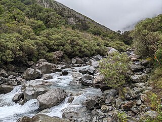
The Deception River is a river in New Zealand. It is a tributary of the West Coast's Otira River, flowing generally north for 17 kilometres (11 mi) from its source on the slopes of Mount Franklin. It passes close to Goat Pass, which gives access to the Mingha River. Almost the entire length of the river is within the Arthur's Pass National Park.
The Haupiri River is a river of New Zealand. It starts near Mount Dixon in the Kaimata Range of the Southern Alps and flows north-west near to Lake Haupiri, then north-east to join the Ahaura River. The Ahaura joins the Grey River which flows into the Tasman Sea at Greymouth.

The Kokatahi River is a river of the West Coast Region of New Zealand's South Island. A major tributary of the Hokitika River, it flows northwest from its origins on the northern slopes of Mount Ambrose, reaching the Hokitika River 12 kilometres from the latter's mouth at Hokitika. The two rivers between them share one of the West Coast's larger floodplains.
The Nancy River is a river of the West Coast Region of New Zealand's South Island. A tributary of the Ahaura River, it flows generally southwest from its source to the west of Mount Hochstsetter in the Southern Alps, turning west shortly before its outflow, 15 kilometres southeast of Lake Hochstetter.
The Rough River, alternatively known as the Otututu River is a river of the West Coast Region of New Zealand's South Island. A major tributary of the Grey River, it flows south from its sources near Mount Uriah in the Paparoa Range 20 kilometres southeast of Charleston, to reach the Grey River to the southwest of the settlement of Ikamatua. The river is currently shown on maps as Otututu (Rough) River, although this orthography is no longer common for New Zealand Rivers.
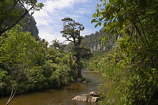
The Pororari River, with an older spelling of Porarari, is a river of the West Coast Region of New Zealand's South Island. It flows northwest from its sources in the Paparoa Range, reaching the Tasman Sea at Punakaiki via Pororari Lagoon. Cave Creek / Kotihotiho is a tributary to the river. There are opportunities to tramp along this river, with two different options accommodating multi-hour loop walks. Further upstream, the Pororari River is followed by the new Paparoa Track, which provides an opportunity for multi-day tramping or mountain biking.

The Waiheke River is a river of the West Coast Region of New Zealand's South Island. It flows west from its origins on Mount Barron in the Southern Alps to reach the Ahaura River, which it forms where it joins the Tūtaekurī River, 20 kilometres northwest of Lake Sumner.
Gough Glacier is an Antarctic glacier about 25 nautical miles (50 km) long, flowing from the northern slopes of the Prince Olav Mountains and the base of the Lillie Range and trending northward to the Ross Ice Shelf, between the Gabbro Hills and the Bravo Hills. It was named by the Southern Party of the New Zealand Geological Survey Antarctic Expedition (1963–64) for A.L. Gough, surveyor of the party.
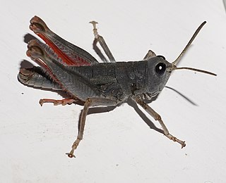
Sigaus villosus is New Zealand's largest grasshopper. It is only found in the central mountains of the South Island. The genus Sigaus is endemic to the New Zealand. Like all of New Zealand sub-alpine and alpine grasshoppers S. villosus has a 2 or 3 years life cycle. The eggs must ‘overwinter’ before they will hatch. Hoppers are found throughout the year and adult grasshoppers can be found throughout the New Zealand summer between December and April. Adult S. villosus do not overwinter.
The Clarke River is a river in the Grey District, one of three Clarke rivers in the South island of New Zealand. It flows northwest for 12 kilometres before joining with the upper Grey River close to the boundary of Victoria Forest Park.
The Robinson River is a river in the West Coast Region of the South Island of New Zealand. It is a tributary of the Upper Grey River and much of the river lies within the Lake Sumner Conservation Park. Rising on the slopes of Mount Boscawen on the main divide about 12 kilometres (7.5 mi) south of the Lewis Pass, the river runs west-southwest along a straight, narrow valley before turning northwest to reach the Upper Grey.
The Taipo River is a river of the central West Coast Region of New Zealand's South Island. It flows north from its sources west of Mount Rolleston, fed by the waters of several mountain streams. After some 15 kilometres it turns northeast to flow past the Bald Range before reaching the valley of the Taramakau River into which it flows 35 kilometres east of Hokitika.
Burnett Creek is a rural locality in the Scenic Rim Region, Queensland, Australia. In the 2016 census, Burnett Creek had a population of 11 people. It borders New South Wales to the south.
