
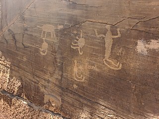
A petroglyph is an image created by removing part of a rock surface by incising, picking, carving, or abrading, as a form of rock art. Outside North America, scholars often use terms such as "carving", "engraving", or other descriptions of the technique to refer to such images. Petroglyphs, estimated to be 20,000 years old are classified as protected monuments and have been added to the tentative list of UNESCO's World Heritage Sites. Petroglyphs are found worldwide, and are often associated with prehistoric peoples. The word comes from the Greek prefix petro-, from πέτρα petra meaning "stone", and γλύφω glýphō meaning "carve", and was originally coined in French as pétroglyphe.
Petroglyphs Provincial Park is a historical-class provincial park situated in Woodview, Ontario, Canada, northeast of Peterborough. It has the largest collection of ancient First Nations petroglyphs in Ontario. The carvings were created in the pre-Columbian era and represents aspects of First Nations spirituality, including images of shamans, animals, reptiles, and, possibly, the Great Spirit itself.

Watters Smith Memorial State Park is a 532-acre (2.15 km2) historical park and national historic district with a pioneer homestead and museum located in Harrison County, West Virginia. The homestead, rising above Duck Creek, is a memorial to settler Watters Smith, who was born in Trenton, New Jersey, in 1767, and moved to Harrison County in what was then Virginia, in 1796, with his wife Elizabeth Davisson Smith. A log cabin similar to the original was moved and reconstructed on the park, together with farm buildings typical of early 19th century settlement. The more modern Smith family home has been restored as a museum, and an additional museum houses many local farm artifacts from earlier eras. Guided tours are offered from Memorial Day weekend through Labor Day. In addition, the park features swimming, picnicking, hiking trails, and horseback riding.

Sanilac Petroglyphs Historic State Park is a state park in the U.S. state of Michigan. The park, also known as ezhibiigadek asin consists of 240 acres (97 ha) in Greenleaf Township, Sanilac County, in Michigan's Thumb. It contains the largest collection of Native American petroglyphs in Michigan. The carvings were created in the pre-Columbian era and represent aspects of Native American spirituality. An interpretive hiking trail within the park passes along the nearby Cass River.

The Roche-a-Cri Petroglyphs, also known as the Friendship Glyphs, are a Registered Historic Place in Roche-a-Cri State Park, near Friendship, Adams County, Wisconsin. They consist of Oneota rock art, mostly petroglyphs resembling birds, canoes and geometric designs. They were added to the National Register of Historic Places in 1981. The petroglyphs were vandalized by soldiers and area settlers between 1845 and the 1880s, notably Company D of the Wisconsin 1st Cavalry Sharpshooters in 1861.
The Leo Petroglyph is a sandstone petroglyph containing 37 images of humans and other animals as well as footprints of each. The petroglyph is located near the small village of Leo, Ohio and is thought to have been created by the Fort Ancient peoples. The area in which the sandstone petroglyph was found is on the edge of an unglaciated Mississippian sandstone cliff 20–65 feet (6.1–19.8 m) high. A 20 by 16 feet slab containing the 37 carvings is protected by a wooden shelter, a Works Progress Administration project. The meanings of the drawings are unknown. On November 10, 1970, it was added to the National Register of Historic Places. The site is maintained by the Ohio History Connection.

The Greaser Petroglyph Site is located on land managed by the Bureau of Land Management in eastern Lake County, Oregon. The designs were scraped into a basalt boulder by Native Americans perhaps 12,000 years ago. No one knows the meaning of the designs. Because of its unique archaeological and cultural significance, the Greaser Petroglyph Site was listed on the National Register of Historic Places in 1974.

The Painted Rock Petroglyph Site is a collection of hundreds of ancient petroglyphs near the town of Theba, Arizona, United States, listed on the National Register of Historic Places in 1977. The site is operated and maintained by the Bureau of Land Management (BLM), and includes an improved campground as well as an informative walking trail showcasing the petroglyphs.

The Barnesville Petroglyph petroglyph site in the eastern part of the U.S. state of Ohio. Located approximately 3 miles (4.8 km) southwest of the village of Barnesville in Belmont County, the petroglyphs have been known both by archaeologists and the general public since the 1850s or earlier. Although the site was significantly damaged during the twentieth century, it is still a significant archaeological site, and has been named a historic site.

Indian God Rock is a large boulder in the northwestern part of the U.S. state of Pennsylvania. Located near the unincorporated community of Brandon, it lies along the Allegheny River in Venango County's Rockland Township. It is significant for the large petroglyph on one of its sides. Because of the petroglyph, the rock has been an explorers' landmark, a tourist attraction, and an object of scholarly investigation.

The Francis Farm Petroglyphs are a group of petroglyphs in southwestern Pennsylvania, United States. Located on a boulder in Jefferson Township in the northwestern portion of Fayette County, the glyphs have been known to archaeologists since at least the middle of the nineteenth century. Despite damage in the 1930s, they remain an important archaeological site, and accordingly, have been designated a historic site.

The Sugar Grove Petroglyphs are a group of petroglyphs in the southwestern part of the U.S. state of Pennsylvania. Located on an outcrop of sandstone in Monongahela Township near the eastern edge of Greene County, the petroglyphs have been known since at least the 1930s. Due to their value as an archaeological site, the petroglyphs have been named a historic site.
Indian Cave Petroglyphs is a historic archaeological site located near Good Hope, Harrison County, West Virginia. It consists of petroglyphs occupying an area of 20 feet by 4 feet on the back wall of a rockshelter. These artifacts were first reported by archaeologist William Henry Holmes (1846-1933) of the Bureau of American Ethnology who visited the area in 1889. He also found pottery that indicates an occupation or occupations between 500 and 1675.

Judaculla Rock is a curvilinear-shaped outcrop of soapstone known for its ancient carvings and petroglyphs. The archaeological site is located on a 0.85-acre rectangular-shaped property, now owned by Jackson County. It is approximately 60 meters east of Caney Fork Creek, a major branch of the northwestward-trending Tuckasegee River in the mountains of Western North Carolina.
Petroglyph Canyon (24CB601) is an archaeologically significant canyon in the northwestern United States. Located on both sides of the border between Montana and Wyoming, the canyon has long been obscure due to its small size. However, it gained substantial attention in the late 20th century because of its numerous prehistoric petroglyphs, and much of it was named a historic site in the 1970s.
The Yellow Jacket Petroglyphs, also known as CA-MNO-2189, are a 9.9-acre (4.0 ha) pre-Columbian archaeological site located in Mono County, California near Bishop, California. The site includes over 200 petroglyphs created by Paiute inhabitants of the region between 2950 B.C. and 1850 A.D. A wide array of design elements were used in the petroglyphs; the majority are abstract curved figures, but abstract lines, anthropomorphs, human and animal tracks, and cupules are also present. The site also includes remnants of human inhabitation, such as stacks of rocks thought to signify house sites, stone tools, ceramics, and animal remains.

The Picture Rock Pass Petroglyphs Site is in northern Lake County, Oregon, United States. The site is located near the summit of Picture Rock Pass on land administered by the Bureau of Land Management. The designs were scraped into a basalt boulder by ancient Native Americans, probably between 7,500 and 12,000 years ago. No one knows the meaning of the petroglyph designs. Because of its unique archaeological and cultural significance, the Picture Rock Pass Petroglyph Site was listed on the National Register of Historic Places in 1975.
The eastern part of the United States state of Maine is known to have historically significant examples of prehistoric and historic rock art. The easternmost shore, particularly the shores and islands of Machias Bay, contain one of the greatest concentrations of rock art on the east coast of North America, with creation dates estimated to range from c. 1000 BCE to beyond the European contact period. Many of these sites are listed on the United States National Register of Historic Places.
The Rocks, also known as Raven's Rock and Raven Rocks, is a late-18th-century stone residence and 79-acre (32 ha) farm complex near Charles Town, Jefferson County, in the U.S. state of West Virginia. The Rocks is a historic district consisting of four contributing structures. The primary structure is a 2-and-a-half-story stone residence known as The Rocks, which was built around 1790, in the Georgian architectural style.

