
The Metropolitan line, colloquially known as the Met, is a London Underground line between Aldgate in the City of London and Amersham and Chesham in Buckinghamshire, with branches to Watford in Hertfordshire and Uxbridge in Hillingdon. Printed in magenta on the tube map, the line is 41.4 miles (66.7 km) in length and serves 34 stations. Between Aldgate and Finchley Road, the track is mostly in shallow "cut and cover" tunnels, apart from short sections at Barbican and Farringdon stations. The rest of the line is above ground, with a loading gauge of a similar size to those on main lines. Just under 94 million passenger journeys were made on the line in 2019.

The Bakerloo line is a London Underground line that runs from Harrow & Wealdstone in suburban north-west London to Elephant & Castle in south London, via the West End. Printed in brown on the Tube map, it serves 25 stations, 15 of which are underground, over 23.2 kilometres (14.4 mi). It runs partly on the surface and partly through deep-level tube tunnels.

The Northern line is a London Underground line that runs from North London to South London. It is printed in black on the Tube map. The Northern line is unique on the Underground network in having two different routes through central London, two southern branches and two northern branches. Despite its name, it does not serve the northernmost stations on the Underground, though it does serve the southernmost station at Morden, the terminus of one of the two southern branches.

The Piccadilly line is a deep-level London Underground line running from the north to the west of London. It has two branches, which split at Acton Town, and serves 53 stations. The line serves Heathrow Airport, and some of its stations are near tourist attractions such as Piccadilly Circus and Buckingham Palace. The District and Metropolitan lines share some sections of track with the Piccadilly line. Printed in dark blue on the Tube map, it is the sixth-busiest line on the Underground network, with nearly 218 million passenger journeys in 2019.

Northwood is an area in the London Borough of Hillingdon, located 14.5 miles (23.3 km) north-west of Charing Cross. Northwood was part of the ancient parish of Ruislip, Middlesex. The area was situated on the historic Middlesex boundary with Hertfordshire, and since being incorporated into Greater London in 1965, has been on the Greater London boundary with that county.
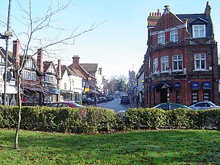
Pinner is a suburb in the London Borough of Harrow, northwest London, England, 12 miles (19 km) northwest of Charing Cross, close to the border with Hillingdon, historically in the county of Middlesex. The population was 38,698 in 2021.

The London Borough of Harrow is a London borough in northwest London, England; it forms part of Outer London. It borders four other London boroughs – Barnet to the east of ancient Watling Street, Brent to the southeast, Ealing to the south and Hillingdon to the west – plus the Hertfordshire districts of Three Rivers and Hertsmere to the north. The local authority is Harrow London Borough Council. The London borough was formed in 1965, based on boundaries that had been established in 1934. The borough is made up of three towns: Harrow, Pinner and Stanmore, but also includes western parts of Edgware.

Kenton is a railway station on the Watford DC line and the Bakerloo line, situated on Kenton Road in Kenton, north-west London. The station is served by London Overground and London Underground services. It has an out of station interchange (OSI) with Northwick Park station on the London Underground's Metropolitan line. On the London Underground’s Bakerloo line, the station is between Harrow & Wealdstone and South Kenton stations.

Harrow is a large town in Greater London, England, and serves as the principal settlement of the London Borough of Harrow. Lying about 9.5 miles (15.3 km) north-west of Charing Cross and 5.4 miles (8.7 km) south of Watford, the entire town including its localities had a population of 149,246 at the 2011 census, whereas the wider borough had a population of 250,149.

Harrow Weald is a suburban district in Greater London, England. Located about 2 miles (3.2 km) north of Harrow, Harrow Weald is formed from a leafy 1930s suburban development along with ancient woodland of Harrow Weald Common. It forms part of the London Borough of Harrow.

Northwood Hills is a London Underground station on the Metropolitan line in the area of Northwood, between Northwood and Pinner stations and is in Travelcard Zone 6.
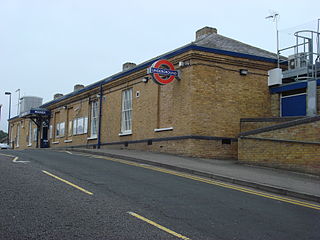
Pinner is a London Underground station on the Metropolitan line in zone 5. The station was opened in 1885 as part of the Victorian expansion of dormitory suburbs, and was one of the stations included in the Metro-land project in the early 20th century. The site is served by several bus routes including links to the Hatch End railway station which was known as Pinner & Hatch End prior to 1920. Step free facilities were opened in 2008. Its adjacent stations are Northwood Hills (northbound) and North Harrow (southbound).

London Sovereign Limited, trading as London Sovereign, is a bus company in North London. It is a subsidiary of RATP Dev Transit London and operates buses under contract to Transport for London.

London Buses route 12 is a Transport for London contracted bus route in London, England. Running between Dulwich Library and Oxford Circus, it is operated by London Central.
London Buses route 15 is a Transport for London contracted bus route in London, England. Running between Blackwall and Charing Cross stations, it is operated by Blue Triangle.
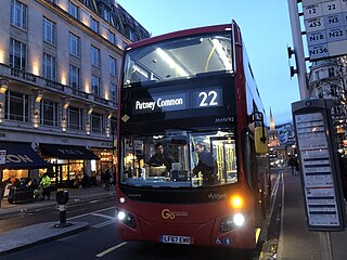
London Buses route 22 is a Transport for London contracted bus route in London, England. Running between Putney Common and Oxford Circus, it is operated by London General.

London Buses route 183 is a Transport for London contracted bus route in London, England. Running between Pinner and Golders Green stations, it is operated by London Sovereign.

Harlesden railway station was a station in northwest London on the south side of the southern section of a road called Craven Park, which is part of the A404 Harrow Road between Paddington and Wembley. The station was sometimes known as Harrow Road or as Stonebridge Park.

Trolleybuses served the London Passenger Transport Area from 1931 until 1962. For much of its existence, the London system was the largest in the world. It peaked at 68 routes, with a maximum fleet of 1,811 trolleybuses.
Pinner Green is a small area of Pinner, in the north-west of the London Borough of Harrow, 13.2 miles north-west of Charing Cross. It is a suburban area mostly occupied by family houses and flats, with a small parade of independent shops, a Tesco supermarket and a modern Shell forecourt.

