
The Jubilee line is a London Underground line that runs between Stanmore in suburban north-west London and Stratford in east London, via the Docklands, South Bank and West End. Opened in 1979, it is the newest line on the Underground network, although some sections of track date back to 1932 and some stations to 1879.

The Northern line is a London Underground line that runs between North London and South London. It is printed in black on the Tube map. It carries more passengers per year than any other Underground line – around 340 million in 2019 – making it the busiest tube line in London. The Northern line is unique on the Underground network in having two different routes through central London, two southern branches and two northern branches. Despite its name, it does not serve the northernmost stations on the Underground, though it does serve the southernmost station at Morden, the terminus of one of the two southern branches.

The Piccadilly line is a deep-level London Underground line running from the north to the west of London. It has two branches, which split at Acton Town, and serves 53 stations. The line serves Heathrow Airport, and some of its stations are near tourist attractions such as Piccadilly Circus and Buckingham Palace. The District and Metropolitan lines share some sections of track with the Piccadilly line. Printed in dark blue on the Tube map, it is the sixth-busiest line on the Underground network, with nearly 218 million passenger journeys in 2019.

North Greenwich is a London Underground station. Despite its name, it is not in the local area historically known as North Greenwich, on the Isle of Dogs, north of the River Thames, which used to be served by a completely different North Greenwich station from 1872 until 1926. The present station is actually closer to Charlton than to Greenwich, although it is at the northernmost tip of the Royal Borough of Greenwich.

Canning Town is an interchange station located in Canning Town, London for London Underground, Docklands Light Railway (DLR) and London Buses services.

West Ham is a London Underground, Docklands Light Railway (DLR) and National Rail intermodal interchange station in West Ham, London, United Kingdom. The station is served by London Underground's District, Hammersmith & City and Jubilee lines, the Stratford International branch of the DLR, and c2c National Rail services.

Stanmore is a London Underground station in Stanmore, north-west London. It is the northern terminus of the Jubilee line and the next station towards south is Canons Park. The station is on the south side of London Road and is in Travelcard Zone 5.

The Jubilee Line Extension (JLE) is the extension of the London Underground Jubilee line from Green Park to Stratford through south and east London. An eastward extension of the line was first proposed in the 1970s. As part of the development of London Docklands, the line was extended to serve Canary Wharf and other areas of south and east London. Construction began in 1993, and it opened in stages from May to December 1999, at a cost of £3.5 billion.

Custom House is an interchange station by the Royal Docks, in Custom House in the London Borough of Newham, London for Docklands Light Railway (DLR) – on which it is branded Custom House for ExCeL – and Elizabeth line services. It is situated in Travelcard Zone 3.

Brondesbury is a station on the Mildmay line of the London Overground. It is situated on a viaduct crossing Kilburn High Road in the Brondesbury area of Kilburn in the London Borough of Brent. It is approximately 200 m (660 ft) south-east of Kilburn station and half a mile north-west of Kilburn High Road station.

Crossharbour is a light metro station on the Docklands Light Railway (DLR) Bank-Lewisham Line in Cubitt Town, East London. The station is situated on the Isle of Dogs and is between Mudchute and South Quay stations and is in Travelcard Zone 2.

Maryland railway station is on the Great Eastern Main Line serving the Maryland area of the London Borough of Newham, east London. It is 4 miles 39 chains (7.2 km) down the line from London Liverpool Street and is situated between Stratford and Forest Gate. Its three-letter station code is MYL and it is in fare zone 3.

Tottenham Hale is an interchange station located in Tottenham Hale, North London for London Underground and National Rail services.

All Saints is a Docklands Light Railway (DLR) station in Poplar in East London. The station is named after nearby All Saints, a Church of England parish church dating from 1821 to 1823. The station entrance is on the East India Dock Road, the high street of Poplar and is opposite Chrisp Street Market while adjacent to the Poplar Baths, it also has two rail sidings directly west of the station forming part of Poplar DLR depot.

Hackney Central is a station on the Mildmay line of the London Overground, located in the London Borough of Hackney. It lies between Dalston Kingsland and Homerton in Travelcard Zone 2. The station and the trains serving it are operated by Transport for London.

Stratford International is a National Rail station in Stratford and a separate Docklands Light Railway (DLR) station nearby, located in East Village in London. Despite its name, no international services stop at the station; plans for it to be served by Eurostar trains never came to fruition. The National Rail platforms are served by Southeastern trains on the High Speed 1 route originating at London St Pancras International. On the DLR, it is a terminus – one of seven end-of-the-line termini – for local services via Canning Town and London City Airport.

Bletchleyrailway station serves the southern parts of Milton Keynes, England, and the north-eastern parts of Aylesbury Vale. It is 47 miles (76 km) northwest of Euston, about 32 miles (51 km) east of Oxford and 17 miles (27 km) west of Bedford, and is one of the seven railway stations serving the Milton Keynes urban area.

Westfield Stratford City is a shopping centre in Stratford, East London, which opened on 13 September 2011. With a total retail floor area of 1,910,000 square feet (177,000 m2), it is the largest urban shopping centre in the UK by land area and the 4th-largest shopping centre in the UK by retail space, behind Westfield London, the MetroCentre, and the Trafford Centre.

Westfield London is a large shopping centre in White City, west London, England, developed by the Westfield Group at a cost of £1.6bn, on a brownfield site formerly the home of the 1908 Franco-British Exhibition. The site is bounded by the West Cross Route (A3220), the Westway (A40) and Wood Lane (A219). It opened on 30 October 2008 and became the largest covered shopping development in the capital; originally a retail floor area of 1,600,000 sq ft (150,000 m2), further investment and expansion led to it becoming the largest shopping centre in the UK and Europe by March 2018, an area of 2,600,000 sq ft (240,000 m2).
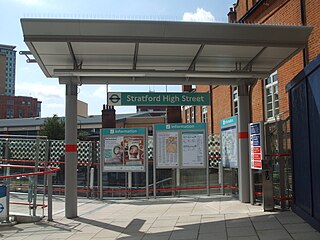
Stratford High Street is a Docklands Light Railway station in Stratford in London, England. It is located on the Stratford International branch of the Docklands Light Railway, which opened on 31 August 2011. The site was the location of an earlier railway station from 1847 to 1957, known initially as Stratford Bridge and later as Stratford Market - after the nearby wholesale fruit and vegetable market.
