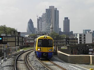
The East London line is part of the London Overground, running north to south through the East, Docklands and South areas of London. It was previously a line of the London Underground.

The Jubilee line is a London Underground line that runs between Stanmore in suburban north-west London and Stratford in east London, via the Docklands, South Bank and West End. Opened in 1979, it is the newest line on the Underground network, although some sections of track date back to 1932 and some stations to 1879.

Liverpool Street station, also known as London Liverpool Street, is a major central London railway terminus and connected London Underground station in the north-eastern corner of the City of London, in the ward of Bishopsgate Without. It is the terminus of the West Anglia Main Line to Cambridge, the Great Eastern Main Line to Norwich, commuter trains serving east London and destinations in the East of England, and the Stansted Express service to Stansted Airport.

Broad Street was a major rail terminal in the City of London, adjacent to Liverpool Street station. It served as the main terminus of the North London Railway (NLR) network, running from 1865 to 1986. During its lifetime, it catered for mainly local suburban services around London, and over time struggled to compete with other modes of transport, leading to its closure.
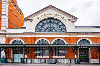
The London Transport Museum (LTM) is a transport museum based in Covent Garden, London. The museum predominantly hosts exhibits relating to the heritage of London's transport, as well as conserving and explaining the history of it. The majority of the museum's exhibits originated in the collections of London Transport, but, since the creation of Transport for London (TfL) in 2000, the remit of the museum has expanded to cover all aspects of transport in the city and in some instances beyond.

Canada Water is an area of the Docklands in south-east London. It is named after a freshwater lake and wildlife refuge. Canada Water tube, Overground and bus station is immediately north of the lake, along with Canada Water Library which overhangs the lake and Deal Porter Square. Surrey Quays Shopping Centre is also adjacent, sitting immediately to the south. The surrounding area, which forms the town centre of Rotherhithe, is now increasingly known as Canada Water, after the transport interchange as much as the lake itself.

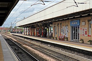
Forest Gate railway station is on the Great Eastern Main Line serving Forest Gate in the London Borough of Newham, east London. It is 5 miles 21 chains (8.5 km) down the line from London Liverpool Street and is situated between Maryland and Manor Park. Its three-letter station code is FOG and it is in fare zone 3.

Broadgate is a large, 32-acre (13 ha) office and retail estate in the Bishopsgate Without area of the City of London. It is owned by British Land and GIC and managed by Savills.
Warrington Bank Quay is one of three railway stations serving the town centre of Warrington in Cheshire, England. It is a principal stop on the West Coast Main Line between London Euston and Glasgow Central. The station is a north–south oriented main-line station on one side of the main shopping area, with the west–east oriented Warrington West and Warrington Central operating a more frequent service to the neighbouring cities of Liverpool and Manchester.

Fulwell Bus Garage is a Transport for London bus garage located in Twickenham in west London. It is north of Fulwell railway station and operates as two halves, with entrances on the A311 Wellington Road and B358 Stanley Road. It is currently operated by Transport UK London Bus and London United.

London Buses route 42 is a Transport for London contracted bus route in London, England. Running between East Dulwich and Shoreditch, it is operated by London Central.

Aldgate bus station serves the Aldgate area of the City of London, England. The station is owned and maintained by Transport for London and located directly south of Aldgate tube station.

Walthamstow Bus Station serves Walthamstow town centre in Waltham Forest, London, England. The station is owned and maintained by Transport for London. The station can be accessed from both Selborne Road and High Street as well as Walthamstow Central tube station. Fifteen bus routes serve the station, with three night bus routes also serving the station.

Stratford bus station is a bus station and taxi rank in Stratford in London, England. The station is owned and maintained by Transport for London. An entrance to Stratford station is located adjacent to the bus station, while Westfield Stratford City and Stratford City bus station are located across the link bridge on the other side of the railway.

Harrow bus station serves the town of Harrow in the London Borough of Harrow, Greater London, England. The station is owned and maintained by Transport for London.
Vauxhall bus station is a bus station in Vauxhall, in the London Borough of Lambeth. It is operated by London Buses and owned and maintained by Transport for London, and is the second busiest bus station in the city.

Heathrow Central bus station is a large bus station that serves terminals 2 and 3 of Heathrow Airport, in London, England. It provides urban bus and long-distance coach services to destinations in London and to regional destinations across Britain. It is the UK's busiest bus and coach station with over 1,600 services each day to over 1,000 destinations. An estimated 13% of air passengers using Heathrow Airport use bus and coach services from Heathrow Central bus station.
Kingsland Viaduct is a railway viaduct about 2 miles (3 km) in length from Shoreditch to Dalston, wholly within the present London Borough of Hackney in east and north-east part of London. It was built in the 1860s, but was disused from 1986 until it was reopened to carry the London Overground in 2010. The viaduct is owned by Transport for London. Since then it has carried East London Line services between Shoreditch High Street and Dalston.

The Angel is an area on the northern fringes of Central London within the London Borough of Islington. It is 2 miles (3.2 km) north-northeast of Charing Cross on the Inner Ring Road at a busy transport intersection. The area is identified in the London Plan as one of 35 major centres in London. It is a significant commercial and retail centre, and a business improvement district. The Angel straddles the ancient boundary of the parishes of Clerkenwell and Islington that later became the metropolitan boroughs of Finsbury and Islington. It is named from the former Angel Inn which stood on the corner of Islington High Street and Pentonville Road. Since 1965 the whole area has formed part of the London Borough of Islington in Greater London.
The metropolitan area of London, England, United Kingdom, is served by six international airports and several smaller airports. Together, these airports constitute the busiest airport system in the world by passenger numbers and the second-busiest by aircraft movements. In 2018, the six airports handled a total of 177,054,819 passengers. The London airports handle over 60% of all the UK's air traffic. The airports serve a total of 14 domestic destinations and 396 international destinations.
