London Docklands is the riverfront and former docks in London. It is located in inner east and southeast London, in the boroughs of Southwark, Tower Hamlets, Lewisham, Newham, and Greenwich. The docks were formerly part of the Port of London, at one time the world's largest port. After the docks closed, the area had become derelict and poverty-ridden by the 1980s. The Docklands' regeneration began later that decade; it has been redeveloped principally for commercial and residential use. The name "London Docklands" was used for the first time in a government report on redevelopment plans in 1971 and has since been almost universally adopted. The redevelopment created wealth, but also led to some conflict between the new and old communities in the area.

The Bakerloo line is a London Underground line that runs from Harrow & Wealdstone in suburban north-west London to Elephant & Castle in south London, via the West End. Printed in brown on the Tube map, it serves 25 stations, 15 of which are underground, over 23.2 kilometres (14.4 mi). It runs partly on the surface and partly through deep-level tube tunnels.

The Jubilee line is a London Underground line that runs between Stratford in east London and Stanmore in the suburban north-west, via the Docklands, South Bank and West End. Opened in 1979, it is the newest line on the Underground network, although some sections of track date back to 1932 and some stations to 1879.

The Northern line is a London Underground line that runs from North London to South London. It is printed in black on the Tube map. The Northern line is unique on the Underground network in having two different routes through central London, two southern branches and two northern branches. Despite its name, it does not serve the northernmost stations on the Underground, though it does serve the southernmost station at Morden, the terminus of one of the two southern branches.

The Piccadilly line is a deep-level London Underground line running from the north to the west of London. It has two branches, which split at Acton Town, and serves 53 stations. The line serves Heathrow Airport, and some of its stations are near tourist attractions such as Piccadilly Circus and Buckingham Palace. The District and Metropolitan lines share some sections of track with the Piccadilly line. Printed in dark blue on the Tube map, it is the fourth busiest line on the Underground network, with over 210 million passenger journeys in 2011/12.
The Royal Borough of Greenwich is a London borough in southeast Greater London, England. The London Borough of Greenwich was formed in 1965 by the London Government Act 1963. The new borough covered the former area of the Metropolitan Borough of Greenwich and part of the Metropolitan Borough of Woolwich to the east. The local council is Greenwich London Borough Council which meets in Woolwich Town Hall. The council's offices are also based in Woolwich, the main urban centre in the borough.

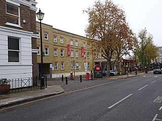
Greenwich station is about 400 m south-west of the district centre, in London, England. It is an interchange between National Rail between central London and Dartford, and the Docklands Light Railway (DLR) between Lewisham to the south and Docklands and the City of London. It is in Travelcard Zones 2 and 3.

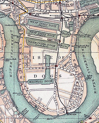
North Greenwich is a London Underground station served by the Jubilee line. Despite its name, it is not in the local area historically known as North Greenwich, on the Isle of Dogs, north of the River Thames; a completely different North Greenwich station used to be there, from 1872 until 1926. It is actually closer to Charlton than to Greenwich; however, it is at the northernmost tip of the Royal Borough of Greenwich, which perhaps gives the best explanation of the name.

The Blackwall Tunnel is a pair of road tunnels underneath the River Thames in east London, England, linking the London Borough of Tower Hamlets with the Royal Borough of Greenwich, and part of the A102 road. The northern portal lies just south of the East India Dock Road (A13) in Blackwall; the southern entrances are just south of The O2 on the Greenwich Peninsula. The road is managed by Transport for London (TfL).

North Greenwich was a railway station named after the North Greenwich area of the Isle of Dogs in London. It was located on the north side of the River Thames near Island Gardens in the east of the city, and is not to be confused with the present-day North Greenwich station on the London Underground's Jubilee line, which is located on the south side of the river, one mile downstream on the Greenwich Peninsula.

London Buses route 188 is a Transport for London contracted bus route in London, England. Running between North Greenwich bus station and Tottenham Court Road station, it is operated by London Central.

The A202 is a primary A road in London. It runs from New Cross Gate to London Victoria station. A section of the route forms a part of the London Inner Ring Road between Vauxhall and Victoria, known as Vauxhall Bridge Road.
Greenwich Park was a railway station opened in 1888 by the London, Chatham and Dover Railway (LCDR) in Greenwich, south-east London. The station was originally called Greenwich and the LCDR intended it to rival a nearby station also named Greenwich which was owned by the South Eastern Railway (SER) and which had opened over 50 years earlier. The LCDR's station was the terminus of a branch line from Nunhead.

Brockley Lane is a closed railway station in Brockley, south London. It was opened in June 1872 by the London, Chatham and Dover Railway on its Greenwich Park Branch Line. It closed to passengers in January 1917 with the branch, but remained open as a goods station until May 1970.

Walthamstow Bus Station serves Walthamstow town centre in Waltham Forest, London, England. The station is owned and maintained by Transport for London. The station can be accessed from both Selborne Road and High Street as well as Walthamstow Central tube station. Fourteen bus routes serve the station, with three night bus routes also serving the station.
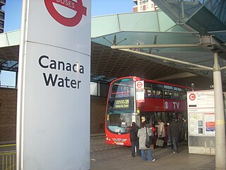
Canada Water bus station serves the Surrey Quays area of the London Borough of Southwark, London, England. The station is owned and maintained by Transport for London.

Bostall Heath and Woods is an area of 159.1 hectares of woodland with areas of heathland located in the Royal Borough of Greenwich ward of Abbey Wood and adjacent to Lesnes Abbey Woods. The area to the south of the A206 is Bostall Woods and to the north is Bostall Heath. The wood is owned and maintained by the Royal Borough of Greenwich, with the exception of the Cooperative Woods, in the north east corner of the site which in 1978 was gifted to the newly formed Bexley and Greenwich Community Hospice by the local community owned Royal Arsenal Co-operative Society founded and based at that time just a short journey away serving locals and workers at the royal arsenal. Unlike Woodlands Farm, a community inner city farm which preserve ancient woodlands and rolling Kent field, the land at Bostall is no longer owned by the consumer owned the co-operative group co-op based in Manchester. The farm and a few residual tracts of ornamental verges between the homes and streets built below bostall woods and named by that society over a century ago remain the last historically significant landholdings of what had been one of Kent's largest and longest lasting employers. The woods, community housing, parks and amenities remain as a lasting investment in the Bostall Woods, and Abbey Woods community of Abbey wood, South London.

The London cable car, also known as the Dangleway and officially as the IFS Cloud Cable Car for sponsorship reasons, is a cable car link across the River Thames in London, England. The line was built by Doppelmayr and the total cost was around £60 million. The service opened on 28 June 2012 and is operated by Transport for London (TfL). Since 20 October 2022, it has been sponsored by the technology firm IFS; prior to this, from its opening the line was sponsored by the airline Emirates, and known as the Emirates Air Line until 28 June 2022.