Havre North, Montana

Last updated
Havre North, Montana
Hill County Montana Incorporated and Unincorporated areas Havre North Highlighted.svg
Location of Havre North, Montana
Coordinates: 48°33′25″N109°39′57″W / 48.55694°N 109.66583°W / 48.55694; -109.66583 Coordinates: 48°33′25″N109°39′57″W / 48.55694°N 109.66583°W / 48.55694; -109.66583
Country United States
State Montana
County Hill
Area
[1]
  Total3.35 sq mi (8.68 km2)
  Land3.35 sq mi (8.68 km2)
  Water0.00 sq mi (0.00 km2)
Elevation
2,475 ft (754 m)
Population
 (2020)
  Total726
  Density216.72/sq mi (83.69/km2)
Time zone UTC-7 (Mountain (MST))
  Summer (DST) UTC-6 (MDT)
Area code 406
FIPS code 30-35125

Havre North is a census-designated place (CDP) in Hill County, Montana, United States. The population was 716 at the 2010 census, [2] down from 973 in 2000.

Contents

Geography

Havre North is located at 48°33′25″N109°39′57″W / 48.55694°N 109.66583°W / 48.55694; -109.66583 (48.556871, -109.665936), [3] along the north side of the city of Havre, the Hill County seat. The Milk River, a tributary of the Missouri River, flows through the CDP from west to east.

According to the United States Census Bureau, the CDP has a total area of 3.4 square miles (8.8 km2), all land. [2]

Demographics

Historical population
CensusPop.Note
2020 726
U.S. Decennial Census [4]

As of the census [5] of 2000, there were 973 people, 422 households, and 259 families residing in the CDP. The population density was 289.7 inhabitants per square mile (111.9/km2). There were 474 housing units at an average density of 141.1 per square mile (54.5/km2). The racial makeup of the CDP was 88.18% White, 0.10% African American, 8.53% Native American, 0.10% Asian, 0.41% from other races, and 2.67% from two or more races. Hispanic or Latino of any race were 0.72% of the population.

There were 422 households, out of which 28.7% had children under the age of 18 living with them, 42.4% were married couples living together, 15.4% had a female householder with no husband present, and 38.6% were non-families. 32.0% of all households were made up of individuals, and 10.9% had someone living alone who was 65 years of age or older. The average household size was 2.30 and the average family size was 2.89.

In the CDP, the population was spread out, with 25.5% under the age of 18, 9.0% from 18 to 24, 28.6% from 25 to 44, 25.1% from 45 to 64, and 11.8% who were 65 years of age or older. The median age was 37 years. For every 100 females, there were 95.8 males. For every 100 females age 18 and over, there were 95.4 males.

The median income for a household in the CDP was $20,888, and the median income for a family was $25,625. Males had a median income of $21,250 versus $17,277 for females. The per capita income for the CDP was $10,921. About 18.8% of families and 23.3% of the population were below the poverty line, including 24.6% of those under age 18 and 2.2% of those age 65 or over.

Related Research Articles

<span class="mw-page-title-main">Lake Louise, Alaska</span> Census-designated place in Alaska, United States

Lake Louise is a census-designated place (CDP) in Matanuska-Susitna Borough, Alaska, United States. Although it is an isolated settlement and is close to Glennallen, it is considered part of the Anchorage Metropolitan Area, like all other locations in the Mat-Su Borough. At the 2020 census the population was 15, down from 46 in 2010 and 88 in 2000.

<span class="mw-page-title-main">Weldon, California</span> Census-designated place in California, United States

Weldon is a census-designated place (CDP) in Kern County, California, United States. It sits at the southeast tip of Lake Isabella. Weldon is located 9 miles (14 km) east-southeast of Wofford Heights, at an elevation of 2,654 feet (809 m). The population was 2,642 at the 2010 census, up from 2,387 at the 2000 census.

<span class="mw-page-title-main">Wainaku, Hawaii</span> Census-designated place in Hawaii, U.S.

Wainaku is a census-designated place (CDP) in Hawaiʻi County, Hawaiʻi, United States. The population was 1,147 at the 2020 census.

<span class="mw-page-title-main">Kaʻaʻawa, Hawaii</span> Census-designated place in the United States

Kaʻaʻawa is a small community and census-designated place (CDP) located in the windward district of Koʻolauloa, City & County of Honolulu on the island of Oʻahu, Hawaiʻi, United States. As of the 2010 Census, the total population for Kaʻaʻawa was 1,379. In Hawaiian, kaʻaʻawa means "the wrasse (fish)". From the Hawaiian spelling Kaʻaʻawa it is seen that each a is pronounced separately and distinctly, set apart by the two ʻokinas: [ˈkɐʔəˈʔɐvə] or [ˈkɐʔəˈʔɐwə].

<span class="mw-page-title-main">Star City, Indiana</span> Census-designated place in Indiana, United States

Star City is a census-designated place (CDP) in Van Buren Township, Pulaski County, in the U.S. state of Indiana. The population was 344 at the 2010 census.

<span class="mw-page-title-main">Mount Lena, Maryland</span> CDP in Maryland, United States

Mount Lena is a census-designated place (CDP) in Washington County, Maryland, United States. The population was 501 at the 2000 census.

<span class="mw-page-title-main">Rocky Boy's Agency, Montana</span> CDP in Montana, United States

Rocky Boy's Agency is a census-designated place (CDP) in Hill County, Montana, United States. The population was 355 at the 2010 census. The settlement developed around the US Indian agency for the Rocky Boy's Indian Reservation.

<span class="mw-page-title-main">Beaver Creek, Montana</span> Census-designated place in Montana, United States

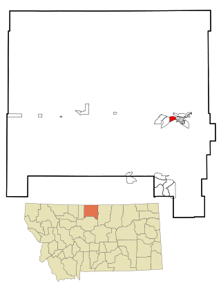
Beaver Creek is a census-designated place (CDP) in Hill County, Montana, United States. The population was 271 at the 2010 census.

<span class="mw-page-title-main">Herron, Montana</span> Census-designated place in Montana, United States

Herron is a census-designated place (CDP) in Hill County, Montana, United States. The population was 43 at the 2010 census.

<span class="mw-page-title-main">Inverness, Montana</span> CDP in Montana, United States

Inverness is a census-designated place (CDP) in Hill County, Montana, United States. The population was 55 at the 2010 census. It was named after a town in Scotland.

<span class="mw-page-title-main">Saddle Butte, Montana</span> Census-designated place in Montana, United States

Saddle Butte is a census-designated place (CDP) in Hill County, Montana, United States. The population was 128 at the 2010 census.

<span class="mw-page-title-main">St. Pierre, Montana</span> Census-designated place in Montana, United States

St. Pierre is a census-designated place (CDP) in Hill County, Montana, United States, within the Rocky Boy Indian Reservation. The population of St. Pierre was 350 at the 2010 census, up from 289 in 2000.

<span class="mw-page-title-main">West Havre, Montana</span> Census-designated place in Montana, United States

West Havre is a census-designated place (CDP) in Hill County, Montana, United States. The population was 316 at the 2010 census, up from 284 in 2000.

<span class="mw-page-title-main">Homeacre-Lyndora, Pennsylvania</span> Census-designated place in Pennsylvania, United States

Homeacre-Lyndora is a census-designated place (CDP) in Butler County, Pennsylvania, United States. The population was 6,906 at the 2010 census.

<span class="mw-page-title-main">Sanatoga, Pennsylvania</span> Census-designated place in Pennsylvania, United States

Sanatoga is a community and census-designated place (CDP) in Lower Pottsgrove Township, Montgomery County, Pennsylvania, United States. It is immediately east of the borough of Pottstown on U.S. Route 422. The population was 8,378 at the 2010 census.

<span class="mw-page-title-main">St. Paul, San Patricio County, Texas</span> CDP in Texas, United States

St. Paul is a census-designated place (CDP) in San Patricio County, Texas, United States. The population was 584 at the 2010 census.

<span class="mw-page-title-main">Parker School, Montana</span> Census-designated place in Montana, United States

Parker School is a census-designated place (CDP) in Hill and Chouteau counties in the U.S. state of Montana. The population was 340 at the 2010 census.

<span class="mw-page-title-main">Kennebunk (CDP), Maine</span> Census-designated place in Maine, United States

Kennebunk is a census-designated place (CDP) comprising the central village in the town of Kennebunk in York County, Maine, United States. The population was 5,214 at the 2010 census, out of a total town population of 10,798. It is part of the Portland–South Portland–Biddeford, Maine Metropolitan Statistical Area.

<span class="mw-page-title-main">Rib Mountain (CDP), Wisconsin</span> CDP in Wisconsin, United States

Rib Mountain is a census-designated place (CDP) in the town of Rib Mountain in Marathon County, Wisconsin, United States. The population was 6,061 at the 2020 census.

Mexico is a census-designated place (CDP) in the town of Mexico in Oxford County, Maine, United States. The population was 1,946 at the 2000 census.

References

  1. "ArcGIS REST Services Directory". United States Census Bureau. Retrieved September 5, 2022.
  2. 1 2 "Geographic Identifiers: 2010 Census Summary File 1 (G001): Havre North CDP, Montana". American Factfinder. U.S. Census Bureau. Archived from the original on February 13, 2020. Retrieved August 23, 2017.
  3. "US Gazetteer files: 2010, 2000, and 1990". United States Census Bureau. 2011-02-12. Retrieved 2011-04-23.
  4. "Census of Population and Housing". Census.gov. Retrieved June 4, 2016.
  5. "U.S. Census website". United States Census Bureau . Retrieved 2008-01-31.