Sangrey, Montana

Last updated

Sangrey, Montana
Hill County Montana Incorporated and Unincorporated areas Sangrey Highlighted.svg
Location of Sangrey, Montana
Coordinates: 48°16′53″N109°48′59″W / 48.28139°N 109.81639°W / 48.28139; -109.81639
Country United States
State Montana
County Hill
Area
[1]
  Total6.31 sq mi (16.35 km2)
  Land6.31 sq mi (16.35 km2)
  Water0.00 sq mi (0.00 km2)
Elevation
3,365 ft (1,026 m)
Population
 (2020)
  Total316
  Density50.06/sq mi (19.33/km2)
Time zone UTC-7 (Mountain (MST))
  Summer (DST) UTC-6 (MDT)
Area code 406
FIPS code 30-66212

Sangrey is a census-designated place (CDP) in Hill County, Montana, United States. The population was 306 at the 2010 census, [2] up from 263 in 2000.

Contents

Geography

Sangrey is located in southeastern Hill County at 48°17′23″N109°50′12″W / 48.28972°N 109.83667°W / 48.28972; -109.83667 (48.289730, -109.836556), [3] within the Rocky Boy Indian Reservation. The CDP is bordered to the north by Azure, to the east by Rocky Boy's Agency, and to the south by St. Pierre, all in Hill County, and to the west by Boneau in Chouteau County.

According to the United States Census Bureau, the Sangrey CDP has a total area of 6.3 square miles (16.4 km2), all land. [2]

Demographics

Historical population
CensusPop.Note
2020 316
U.S. Decennial Census [4]

As of the census [5] of 2000, there were 263 people, 69 households, and 60 families residing in the CDP. The population density was 41.6 inhabitants per square mile (16.1/km2). There were 77 housing units at an average density of 12.2/sq mi (4.7/km2). The racial makeup of the CDP was 0.76% White, 95.82% Native American, 0.38% Asian, and 3.04% from two or more races. Hispanic or Latino of any race were 2.28% of the population.

There were 69 households, out of which 50.7% had children under the age of 18 living with them, 46.4% were married couples living together, 29.0% had a female householder with no husband present, and 13.0% were non-families. 11.6% of all households were made up of individuals, and 1.4% had someone living alone who was 65 years of age or older. The average household size was 3.81 and the average family size was 4.10.

In the CDP, the population was spread out, with 42.6% under the age of 18, 11.0% from 18 to 24, 26.6% from 25 to 44, 15.2% from 45 to 64, and 4.6% who were 65 years of age or older. The median age was 23 years. For every 100 females, there were 92.0 males. For every 100 females age 18 and over, there were 96.1 males.

The median income for a household in the CDP was $20,089, and the median income for a family was $20,446. Males had a median income of $35,417 versus $30,313 for females. The per capita income for the CDP was $6,519. About 54.0% of families and 57.3% of the population were below the poverty line, including 70.2% of those under the age of eighteen and 33.3% of those 65 or over.

Related Research Articles

<span class="mw-page-title-main">North Key Largo, Florida</span> Census-designated place in Florida, United States

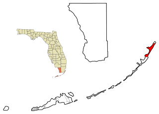
North Key Largo is an unincorporated area and census-designated place (CDP) in Monroe County, Florida, United States. The population was 1,431 at the 2020 census, up from 1,244 in 2010. It includes two private clubs, the Ocean Reef Club and the Key Largo Anglers Club, and is reached from the mainland via the Card Sound Bridge.

<span class="mw-page-title-main">Pepeekeo, Hawaii</span> Census-designated place in Hawaii, U.S.

Pepeekeo is a census-designated place (CDP) in Hawaii County, Hawaii, United States. The population was 1,789 at the 2010 census, up from 1,697 at the 2000 census.

<span class="mw-page-title-main">Robin Glen-Indiantown, Michigan</span> Census-designated place & unincorporated community in Michigan, United States

Robin Glen-Indiantown is a census-designated place (CDP) in Buena Vista Charter Township, Saginaw County in the U.S. state of Michigan. The CDP is used for statistical purposes and has no legal status as an incorporated municipality. The population was 1,158 at the 2000 census.

<span class="mw-page-title-main">Boneau, Montana</span> Census-designated place in Montana, United States

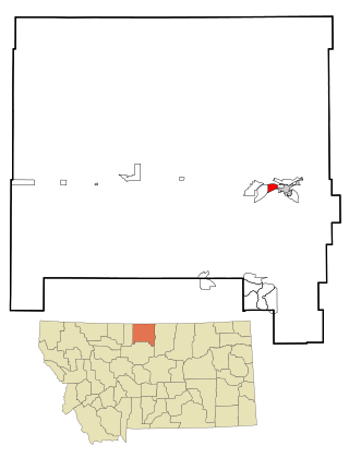
Boneau is a census-designated place (CDP) in Chouteau County, Montana, United States. The population was 380 at the 2010 census, up from 190 in 2000.

<span class="mw-page-title-main">Somers, Montana</span> Unincorporated community in Montana, United States

Somers is an unincorporated community and census-designated place (CDP) in Flathead County, Montana, United States. The population was 1,109 at the 2010 census, up from 556 in 2000.

<span class="mw-page-title-main">Starr School, Montana</span> Census-designated place in Montana, United States

Starr School is a census-designated place (CDP) in Glacier County, Montana, United States. The population was 252 at the 2010 census.

<span class="mw-page-title-main">Beaver Creek, Montana</span> Census-designated place in Montana, United States

Beaver Creek is a census-designated place (CDP) in Hill County, Montana, United States. The population was 271 at the 2010 census.

<span class="mw-page-title-main">Gildford, Montana</span> Census-designated place in Montana, United States

Gildford is an unincorporated community and census-designated place (CDP) in Hill County, Montana, United States. The population was 179 at the 2010 census.

<span class="mw-page-title-main">Havre North, Montana</span> Census-designated place in Montana, United States

Havre North is a census-designated place (CDP) in Hill County, Montana, United States. The population was 716 at the 2010 census, down from 973 in 2000.

<span class="mw-page-title-main">Herron, Montana</span> Census-designated place in Montana, United States

Herron is a census-designated place (CDP) in Hill County, Montana, United States. The population was 43 at the 2010 census.

<span class="mw-page-title-main">Saddle Butte, Montana</span> Census-designated place in Montana, United States

Saddle Butte is a census-designated place (CDP) in Hill County, Montana, United States. The population was 128 at the 2010 census.

<span class="mw-page-title-main">St. Pierre, Montana</span> Census-designated place in Montana, United States

St. Pierre is a census-designated place (CDP) in Hill County, Montana, United States, within the Rocky Boy Indian Reservation. The population of St. Pierre was 350 at the 2010 census, up from 289 in 2000.

<span class="mw-page-title-main">West Havre, Montana</span> Census-designated place in Montana, United States

West Havre is a census-designated place (CDP) in Hill County, Montana, United States. The population was 316 at the 2010 census, up from 284 in 2000.

<span class="mw-page-title-main">Woods Bay, Montana</span> Census-designated place in Montana, United States

Woods Bay is a census-designated place (CDP) in Lake County, Montana, United States. The population was 661 at the 2010 census, down from 748 at the 2000 census.

<span class="mw-page-title-main">East Missoula, Montana</span> CDP in Montana, United States

East Missoula is a census-designated place (CDP) in Missoula County, Montana, United States. It is part of the 'Missoula, Montana Metropolitan Statistical Area'. The population was 2,157 at the 2010 census, an increase from its population of 2,070 in 2000.

<span class="mw-page-title-main">Reserve, Montana</span> CDP in Montana, United States

Reserve is a census-designated place (CDP) in Sheridan County, Montana, United States. The population was 23 at the 2010 census.

<span class="mw-page-title-main">Greycliff, Montana</span> CDP in Montana, United States

Greycliff is a census-designated place (CDP) in Sweet Grass County, Montana, United States. The population was 56 at the 2000 census.

<span class="mw-page-title-main">Azure, Montana</span> Census-designated place in Montana, United States

Azure is a census-designated place (CDP) in Hill County, Montana, United States. The population was 286 at the 2010 census.

<span class="mw-page-title-main">Joplin, Montana</span> Unincorporated community in Montana, United States

Joplin is a unincorporated community and census-designated place (CDP) in Liberty County, Montana, United States. The population was 157 at the 2010 census.

<span class="mw-page-title-main">Hummels Wharf, Pennsylvania</span> CDP in Pennsylvania, United States

Hummels Wharf is a census-designated place (CDP) in Snyder County, Pennsylvania, United States. The population was 641 at the 2000 census.

References

  1. "ArcGIS REST Services Directory". United States Census Bureau. Retrieved September 5, 2022.
  2. 1 2 "Geographic Identifiers: 2010 Census Summary File 1 (G001): Sangrey CDP, Montana". American Factfinder. U.S. Census Bureau. Archived from the original on February 13, 2020. Retrieved August 24, 2017.
  3. "US Gazetteer files: 2010, 2000, and 1990". United States Census Bureau. February 12, 2011. Retrieved April 23, 2011.
  4. "Census of Population and Housing". Census.gov. Retrieved June 4, 2016.
  5. "U.S. Census website". United States Census Bureau . Retrieved January 31, 2008.