Heer Land

Last updated
Heer Land as seen from the air in March 2016. Rindersbukta (front) is covered by sea ice. Heer Land.jpg
Heer Land as seen from the air in March 2016. Rindersbukta (front) is covered by sea ice.

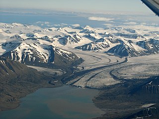
Heer Land is a land area on the east coast of Spitsbergen, Svalbard. It is bordered by Rindersbukta to the southwest, Braganzavågen and Kjellströmdalen to the northwest, Storfjorden to the east and southeast, and Torell Land to the south. It is named after paleobotanist Oswald Heer. [1] Heer Land mainly consist of glaciers and nunataks.

Spitsbergen largest island of the Svalbard archipelago

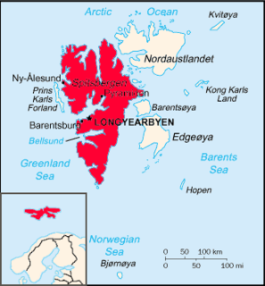
Spitsbergen is the largest and only permanently populated island of the Svalbard archipelago in northern Norway. Constituting the westernmost bulk of the archipelago, it borders the Arctic Ocean, the Norwegian Sea, and the Greenland Sea. Spitsbergen covers an area of 37,673 km2 (14,546 sq mi), making it the largest island in Norway and the 36th-largest in the world. The administrative centre is Longyearbyen. Other settlements, in addition to research outposts, are the Russian mining community of Barentsburg, the research community of Ny-Ålesund, and the mining outpost of Sveagruva. Spitsbergen was covered in 21,977 km2 (8,485 sq mi) of ice in 1999, which was approximately 58.5% of the island's total area.

Svalbard Archipelago in the Arctic Ocean

Svalbard is a Norwegian archipelago in the Arctic Ocean. Situated north of mainland Europe, it is about midway between continental Norway and the North Pole. The islands of the group range from 74° to 81° north latitude, and from 10° to 35° east longitude. The largest island is Spitsbergen, followed by Nordaustlandet and Edgeøya. Administratively, the archipelago is not part of any Norwegian county, but forms an unincorporated area administered by a governor appointed by the Norwegian government. Since 2002, Svalbard's main settlement, Longyearbyen, has had an elected local government, somewhat similar to mainland municipalities. Other settlements include the Russian mining community of Barentsburg, the research station of Ny-Ålesund, and the mining outpost of Sveagruva. Ny-Ålesund is the northernmost settlement in the world with a permanent civilian population. Other settlements are farther north, but are populated only by rotating groups of researchers.

Rindersbukta bay in Svalbard

Rindersbukta is a bay in Nathorst Land and Heer Land at Spitsbergen, Svalbard. It forms the southern branch of Van Mijenfjorden. The glaciers of Scheelebreen and Paulabreen debouche into the bay. The bay is named after Dutch whaler Michiel Rinders.

Coordinates: 77°47′00″N17°53′10″E / 77.78333°N 17.88611°E / 77.78333; 17.88611

Geographic coordinate system Coordinate system

A geographic coordinate system is a coordinate system that enables every location on Earth to be specified by a set of numbers, letters or symbols. The coordinates are often chosen such that one of the numbers represents a vertical position and two or three of the numbers represent a horizontal position; alternatively, a geographic position may be expressed in a combined three-dimensional Cartesian vector. A common choice of coordinates is latitude, longitude and elevation. To specify a location on a plane requires a map projection.

Heer Land is located on the eastern side of Spitsbergen. Spitsbergen labelled.png
Heer Land is located on the eastern side of Spitsbergen.

Related Research Articles

The Molloy Deep is a bathymetric feature at 79°8′30″N2°47′0″E in the Greenland Sea, 160 km from Svalbard, it is the deepest point of Fram Strait.

Jazy, Augustów County Village in Podlaskie, Poland

Jazy is a village in the administrative district of Gmina Płaska, within Augustów County, Podlaskie Voivodeship, in north-eastern Poland, close to the border with Belarus. It lies approximately 8 kilometres (5 mi) east of Płaska, 27 km (17 mi) east of Augustów, and 87 km (54 mi) north of the regional capital Białystok.

Babia Góra, Podlaskie Voivodeship Village in Podlaskie, Poland

Babia Góra is a village in the administrative district of Gmina Narewka, within Hajnówka County, Podlaskie Voivodeship, in north-eastern Poland, close to the border with Belarus. It lies approximately 11 kilometres (7 mi) north-east of Narewka, 28 km (17 mi) north-east of Hajnówka, and 55 km (34 mi) south-east of the regional capital Białystok.

Łańczyno Village in Podlaskie, Poland

Łańczyno is a village in the administrative district of Gmina Narewka, within Hajnówka County, Podlaskie Voivodeship, in north-eastern Poland, close to the border with Belarus. It lies approximately 9 kilometres (6 mi) east of Narewka, 25 km (16 mi) north-east of Hajnówka, and 58 km (36 mi) south-east of the regional capital Białystok.

Kaczorów, Łódź Voivodeship Village in Łódź, Poland

Kaczorów is a village in the administrative district of Gmina Nowy Kawęczyn, within Skierniewice County, Łódź Voivodeship, in central Poland. It lies approximately 11 kilometres (7 mi) south-east of Skierniewice and 55 km (34 mi) east of the regional capital Łódź.

Glitajny is a village in the administrative district of Gmina Bartoszyce, within Bartoszyce County, Warmian-Masurian Voivodeship, in northern Poland, close to the border with the Kaliningrad Oblast of Russia.

Brzeźno, Gmina Barwice Settlement in West Pomeranian, Poland

Brzeźno is a settlement in the administrative district of Gmina Barwice, within Szczecinek County, West Pomeranian Voivodeship, in north-western Poland. It lies approximately 8 kilometres (5 mi) north-west of Barwice, 28 km (17 mi) west of Szczecinek, and 120 km (75 mi) east of the regional capital Szczecin.

Wedel Jarlsberg Land peninsula in Svalbard, Norway

Wedel Jarlsberg Land is the land area between Van Keulenfjorden and Hornsund on the southwestern part of Spitsbergen, Svalbard. The area is largely covered with glaciers, and is completely within the Sør-Spitsbergen National Park.

Nathorst Land land area between Van Keulenfjorden and Van Mijenfjorden on Spitsbergen, Svalbard

Nathorst Land is the land area between Van Keulenfjorden and Van Mijenfjorden on Spitsbergen, Svalbard.

Torell Land area in Svalbard

Torell Land is a land area at the southeast part of Spitsbergen, Svalbard. It is named after Otto Martin Torell. Two glaciers, Hornbreen and Hambergbreen, divide Torell Land from Sørkapp Land.

Bohemanneset is a cape defined by the southeastern spit of Bohemanflya, located at the northwestern side of Isfjorden, in Oscar II Land on Spitsbergen, Svalbard. It is named after Swedish entomologist Carl Henrik Boheman. Bohemanneset has a length of about 2 km (1.2 mi). Older names are Cap Boheman and Cape Boheman.

Kapp Dufferin is a spit located northeast in Heer Land on the island of Spitsbergen in Svalbard, Norway. It is 1-kilometre (0.62 mi) wide with a lagoon, and makes up the eastern part of the coast east of Rjurikfjellet. It is named for Frederick Hamilton-Temple-Blackwood, 1st Marquess of Dufferin and Ava, who visited Svalbard in 1856 and wrote Letters From High Latitudes.

Kjellströmdalen is a valley at Spitsbergen, Svalbard. It has a length of about 27 kilometers, and forms the border between Nordenskiöld Land, Heer Land and Sabine Land. The valley is named after topographer Carl Johan Otto Kjellström. The valley debouches into Braganzavågen, a bay in the inner part of Van Mijenfjorden.

Braganzavågen is a bay located in the inner northern branch of Van Mijenfjorden, at Spitsbergen, Svalbard, within Heer Land and Nordenskiöld Land. The valley Kjellströmdalen debouches into the bay. The mining settlement Sveagruva is located at the western side of Braganzavågen, below the mountain Liljevalchfjellet.

Agardhdalen is a valley between Sabine Land and Heer Land at Spitsbergen, Svalbard. It forms a continuation of the bay Agardhbukta, at the western side of Storfjorden. The valley is named after botanist Jacob Georg Agardh. The river Agardhelva flows from Sveigbreen and Elfenbeinbreen, through Agardhdalen, with outlet into Agardhbukta.

Agardhelva is a river forming the border between Sabine Land and Heer Land at Spitsbergen, Svalbard. It flows through the valley of Agardhdalen, from the glaciers Elfenbeinbreen and Sveigbreen, ending into the bay Agardhbukta at the western side of Storfjorden. The river is named after botanist Jacob Georg Agardh.

Paulabreen glacier at Spitsbergen, Svalbard, Norway

Paulabreen is a glacier in Nathorst Land and Heer Land at Spitsbergen, Svalbard. It has a length of about fifteen kilometers, extending from the mountain of Kjølberget to the bay of Rindersbukta. The glacier is named after Paula, the wife of shipmaster Richard Ritter von Barry. Paulabreen borders to the mountain area of Vriompeisen, and the mountain of Hollertoppen. A tributary glacier is Bakaninbreen.

Bakaninbreen glacier at Spitsbergen, Svalbard, Norway

Bakaninbreen is a glacier in Heer Land at Spitsbergen, Svalbard. It has a length of about 9.5 kilometers, and merges with the glacier of Paulabreen. The glacier is named after a member of the Swedish-Russian Arc-of-Meridian Expedition. The mountain of Hollertoppen is located between Bakaninbreen and Ragna-Mariebreen.

Hollertoppen glacier in Svalbard

Hollertoppen is a mountain in Heer Land at Spitsbergen, Svalbard. It has a height of 1,012 m.a.s.l., and is located between the glaciers of Bakaninbreen and Ragna-Mariebreen, north of Paulabreen. The mountain is named after Norwegian Minister of Industry Kjell Holler.

References

  1. "Heer Land (Svalbard)". Norwegian Polar Institute . Retrieved 11 October 2017.