Svalbard ( SVAHL-bar, Urban East Norwegian: [ˈsvɑ̂ːɫbɑr]; prior to 1925 known as Spitsbergen, or Spitzbergen, is a Norwegian archipelago in the Arctic Ocean. Situated north of mainland Europe, it is about midway between continental Norway and the North Pole. The islands of the group range from 74° to 81° north latitude, and from 10° to 35° east longitude. The largest island is Spitsbergen, followed by Nordaustlandet and Edgeøya. While part of the Kingdom of Norway since 1925, Svalbard is not part of geographical Norway; administratively, the archipelago is not part of any Norwegian county, but forms an unincorporated area administered by a governor appointed by the Norwegian government, and a special jurisdiction subject to the Svalbard Treaty that is outside of the Schengen Area, the Nordic Passport Union and the European Economic Area.
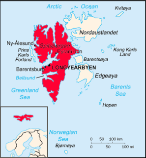
Spitsbergen is the largest and only permanently populated island of the Svalbard archipelago in northern Norway. Constituting the westernmost bulk of the archipelago, it borders the Arctic Ocean, the Norwegian Sea, and the Greenland Sea. Spitsbergen covers an area of 37,673 km2 (14,546 sq mi), making it the largest island in Norway and the 36th-largest in the world. The administrative centre is Longyearbyen. Other settlements, in addition to research outposts, are the Russian mining community of Barentsburg, the research community of Ny-Ålesund, and the mining outpost of Sveagruva. Spitsbergen was covered in 21,977 km2 (8,485 sq mi) of ice in 1999, which was approximately 58.5% of the island's total area.

Longyearbyen is the largest settlement and the administrative centre of Svalbard, Norway. It stretches along the foot of the left bank of the Longyear Valley and on the shore of Adventfjorden, the short estuary leading into Isfjorden on the west coast of Spitsbergen, the island's broadest inlet. Since 2002 Longyearbyen Community Council has had many of the same responsibilities as a Norwegian municipality, including utilities, education, cultural facilities, fire brigade, roads and ports. The town is the seat of the Governor of Svalbard. It is the world's northernmost settlement of any kind with more than 1,000 permanent residents. Since 2015 Arild Olsen has served as Mayor.

Barentsburg is the second-largest settlement on Svalbard, with about 470 inhabitants (2015), almost entirely made up of ethnic Russians and Ukrainians.
The polar archipelago of Svalbard was first discovered by Willem Barentsz in 1596, although there is disputed evidence of use by Pomors or Norsemen. Whaling for bowhead whales started in 1611, dominated by English and Dutch companies, though other countries participated. At that time there was no agreement about sovereignty. Whaling stations, the largest being Smeerenburg, were built during the 17th century, but gradually whaling decreased. Hunting was carried out from the 17th century by Pomors, but from the 19th century it became more dominated by Norwegians.

Pyramiden is an abandoned Soviet coal mining settlement on the Norwegian archipelago of Svalbard which became a popular touristic destination. Founded by Sweden in 1910 and sold to the Soviet Union in 1927, Pyramiden was closed in 1998 and has since remained largely abandoned with most of its infrastructure and buildings still in place, the cold climate preserving much of what has been left behind.
Svalbard lies under the sovereignty of Norway, but the Svalbard Treaty places several restrictions. Norway cannot use the archipelago for warlike purposes, cannot discriminate economic activity based on nationality and is required to conserve the natural environment. Uniquely, Svalbard is an entirely visa-free zone. Everybody may live and work in Svalbard indefinitely regardless of country of citizenship. Svalbard Treaty grants treaty nationals equal right of abode as Norwegian nationals. Non-treaty nationals may live and work indefinitely visa-free as well. "Regulations concerning rejection and expulsion from Svalbard" is in force on non-discriminatory basis.

Vnukovo Airlines Flight 2801 was an international charter flight from Vnukovo International Airport in Moscow, Russia to Svalbard Airport in Longyearbyen, Svalbard Norway. On 29 August 1996, at 10:22:23 Central European Summer Time, a Tupolev Tu-154M operating this flight crashed in Operafjellet, Svalbard, during the approach to Svalbard Airport, Longyear. All 141 people aboard the plane were killed, making it the deadliest aviation accident ever in Norway. The accident was the result of a series of small navigational errors causing the aircraft to be 3.7 kilometres from the approach centerline at the time of impact.

Værøy Heliport is a heliport located at Tobbisodden on the island of Værøya in Værøy Municipality in Nordland county, Norway. The heliport lies close to the village of Sørland, the municipal centre of the municipality. The airport, operated by the state-owned Avinor, consists of a single helipad and handled 9,420 passengers in 2014. Services are provided by Lufttransport using the AgustaWestland AW139 to the nearby mainland town of Bodø, based on a public service obligation contract.

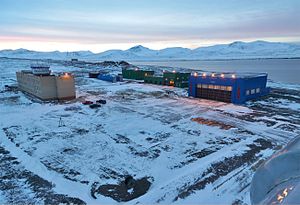
Svalbard Airport, Longyear is the main airport serving Svalbard in Norway. It is 5 km (3.1 mi) northwest of Longyearbyen on the west coast, and is the northernmost airport in the world with scheduled public flights. The first airport near Longyearbyen was constructed during World War II. In 1959, it was first used for occasional flights, but could only be used a few months a year. Construction of the new airport at Hotellneset started in 1973, and the airport was opened on 2 September, 1975. It is owned and operated by state-owned Avinor.

Ny-Ålesund Airport, Hamnerabben is an airport serving the research community of Ny-Ålesund in Svalbard, Norway. The airport is owned by Kings Bay, who also owns the company town. The only flights available are to Svalbard Airport, Longyear, operated two to four times a week by Lufttransport using Dornier Do 228 aircraft. The services are organized as corporate charters and tickets are only available after permission from Kings Bay.

Svea Airport is a private airport located in and serving the Sveagruva in Svalbard, Norway. The airport is owned and operated by Store Norske Spitsbergen Kulkompani, who use the airport to transport their coal mining workers from the company town to Longyearbyen and Svalbard Airport, Longyear. The airport features a gravel runway measuring 800 by 30 meters. Flights are operated about thirty times per week by Lufttransport using their two Dornier Do 228s.

Arktikugol is a Russian coal mining unitary enterprise which operates on the islands of Spitsbergen in Svalbard, Norway. Owned by the Government of Russia, Arktikugol currently has limited mining in Barentsburg. It has carried out mining operations and still owns the towns of Pyramiden and Grumant, with its port at Colesbukta. The company is headquartered in Moscow and is the official agency through which Russia, and previously the Soviet Union, exercised its Svalbard policy.

The economy of Svalbard is dominated by coal mining, tourism and research. In 2007, there were 484 people working in the mining sector, 211 people working in the tourism sector and 111 people working in the education sector. The same year, mining gave a revenue of 2.008 billion kr, tourism NOK 317 million and research 142 million. In 2006, the average income for economically active people was NOK 494,700, or 23% higher than on the mainland. Almost all housing is owned by the various employers and institutions and rented to their employees; there are only a few privately owned houses, most of which are recreational cabins. Because of this, it is nearly impossible to live on Svalbard without working for an established institution. The Spitsbergen Treaty and Svalbard Act established Svalbard as an economic free zone and demilitarized zone in 1925.

Svalbard, Norway, is a vast, very sparsely inhabited Arctic archipelago. With fewer than 3,000 inhabitants in four communities, plus some smaller meteorological and scientific outposts, there are no communities connected by road. Off-road motorized transport is prohibited on bare ground, but snowmobiles are used extensively during winter, both for commercial and recreational activities. Transport from Longyearbyen to Barentsburg and Pyramiden is possible by snowmobile at winter, or by ship all year round. Road systems exist within the communities of Longyearbyen, Barentsburg, Sveagruva and Ny-Ålesund. All settlements have ports and Longyearbyen has a bus system.

Isfjord Radio is a coast radio station, weather station and hotel located at Kapp Linné on the island Spitsbergen in Svalbard, Norway. The station was established in 1933, and has played an important role in the telecommunications between the Svalbard archipelago and the outside world. The station was destroyed by both sides during World War II, and rebuilt in 1946. The station was important for ships traffic and air traffic. Satellite communications were established in 1979, but depreciated when a fiber optic cable between Svalbard and the mainland was finished in 2004. Isfjord Radio was automated and depopulated in 1999. Parts of the outdated installations have been preserved as a historical site.

Pyramiden Heliport is a heliport located at Pyramiden in Svalbard, Norway. The airport is owned and operated by Arktikugol, who owns the mining town. The airport consists of a gravel runway and apron measuring 90 by 40 meters and a small terminal building. There is capacity for up to three helicopters on the apron. Flights are carried out by Spark+ using two Mil Mi-8 helicopters. Flights are flown to Barentsburg Heliport, Heerodden and Svalbard Airport, Longyear at irregular intervals.

Agriculture in Svalbard – the world's northernmost – has a short history, and remains a minor economic factor, but has nonetheless had a culturally and socially significant role, as well as an ecologic impact. Svalbard is home to the Global Seed Vault, which serves to protect the world's biological and agricultural diversity. Polar Permaculture Solutions, AS was formed in January 2015. Polar Permaculture has been focused on producing locally grown food in town, and also with composting food waste.

The Barentsburg Pomor Museum is a small museum located in Barentsburg, a town in Svalbard, a Norwegian archipelago in the Arctic Ocean. Created during the 1920s by the Dutch, the coal mining settlement was sold to the Soviet Union in 1932, and so it was the USSR which founded the museum in 1963. Today owned entirely by the Government of Russia through Arktikugol, Barentsburg is a shadow of its former self, with only a few hundred inhabitants compared to over a thousand during its heyday. The museum remains intact however, receiving most of its visitors in the form of tourists. It shares the same building as the town's Sports and Culture Centre.