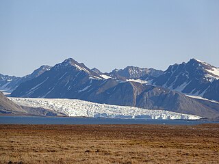
Albert I Land is the land area of the northwestern part of Spitsbergen, Svalbard. It is bordered by Haakon VII Land to the southeast. To the northeast lies Raudfjorden and its inner branch, Klinckowströmfjorden, to the southeast Krossfjorden and its inner branch, Lilliehöökfjorden, to the west and north the Arctic Ocean.
Holtedahlfonna is a glacier at Haakon VII Land on Spitsbergen, Svalbard, between Wijdefjorden and Kongsfjorden. The glacier covers an area of about 1,375 km2 (531 sq mi), and is the second largest ice cap on Spitsbergen. It is named after Norwegian geologist and polar explorer Olaf Holtedahl.
Liefdefjorden is a fjord in Haakon VII Land on Spitsbergen, Svalbard. It has a length of about 30 km (19 mi). Former names of the fjord include Baye d'Amour, Kjærlighedsbugten, Porto detto l'Amato, Liefde Bay and Love Bay. Monacobreen debouches into the fjord. At the northern side of the outer part of the fjord is the peninsula Reinsdyrflya. Liefde is Dutch for "love" and the fjord is possible named after a ship "de Liefde".

Monacobreen is a glacier in Haakon VII Land on Spitsbergen, Svalbard. The glacier debouches into Liefdefjorden. Former names of the glacier include Glacier de Monaco and Liefde Bay-bræ.

Blomstrandbreen is a glacier in Haakon VII Land at the western side of Spitsbergen, Svalbard. It has a length of 18 kilometres, extending from Isachsenfonna down to Kongsfjorden. The glacier is named after geologist Christian Wilhelm Blomstrand. To the northwest of the glacier is the mountain area of Mercantonfjellet.
Kong Haakons Halvøy is a 12 kilometer long peninsula and mountain ridge in Haakon VII Land at Spitsbergen, Svalbard. The ridge forms a peninsula in the fjord Krossfjorden, and separates the fjord branches Lilliehöökfjorden and Möllerfjorden. The peninsula is named after King Haakon VII of Norway.

Reinsdyrflya is a peninsula in Haakon VII Land at Spitsbergen, Svalbard, Norway. It defines the western side of the outer part of Woodfjorden, and the northern side of the outer part of Liefdefjorden.
Bockfjorden is a fjord in Haakon VII Land at Spitsbergen, Svalbard, at the western side of Woodfjorden. Bockfjorden is named after Arctic explorer Franz-Karl von Bock. At the western side of the fjord is the inactive volcano Sverrefjellet.
Vonbreen is a glacier in Haakon VII Land and Andrée Land at Spitsbergen, Svalbard. It has an extension of about 25 kilometers, and is located south of Woodfjorden. The name is a translation of the German language Hoffnungs-Gletscher, suggested by Bock and Poninski in 1908. The glacier borders to Eidsvollfjellet, the highest mountain in Haakon VII Land.
Poninskiøyra is a flat sand and clay area in Woodfjorddalen in Andrée Land and Haakon VII Land at Spitsbergen, Svalbard. It is located at the lower part of the valley, and includes the hill Tantalushaugen. The area is named after military officer and cartographer Bernhard Graf von Poninski, who made stereophotogrammetrical mapping of the Woodfjorden area during an expedition in 1907.
Eidsvollfjellet is a mountain in Haakon VII Land at Spitsbergen, Svalbard. The mountain has a height of 1,449 m.a.s.l. and is located between Vonbreen and Isachsenfonna, north of Snøfjella. Eidsvollfjellet is the highest mountain in Haakon VII Land.
Mercantonfjellet is a mountain area in Haakon VII Land at Spitsbergen, Svalbard. It has a length of about seven kilometres, and is located between Fjortende Julibreen and Blomstrandbreen. Among the peaks are Svansen and Sveitsartoppen. The area is named after Swiss glaciologist Paul Louis Mercanton.

Fjortende Julibreen is a glacier in Haakon VII Land at Spitsbergen, Svalbard. It has a length of about sixteen kilometers, and a total area of about 127 km2. It is located between Reppingen, Løvlandfjellet and Mercantonfjellet to the south, and Casimir-Périerkammen, Forelryggen and Foreltinden to the north, and extends down to Fjortende Julibukta in Krossfjorden. The glacier is named after the National Day of France, the 14 July.
Løvlandfjellet is a mountain in Haakon VII Land at Spitsbergen, Svalbard. It reaches a height of 943 m.a.s.l., and is located north of Kongsfjorden, between the glaciers of Junibreen, Løvlandbreen, Svansbreen, Maibreen and Fjortende Julibreen. The mountain is named after Norwegian politician Jørgen Løvland.
Foreltinden is a mountain in Haakon VII Land at Spitsbergen, Svalbard. It reaches a height of 1,275 m.a.s.l., and is located east of Tinayrebukta in Krossfjorden, between Målarryggen and Forelryggen. The mountain is named after Swiss glaciologist and limnologist François-Alphonse Forel.

Lilliehöökbreen is a glacier complex in Albert I Land and Haakon VII Land at Spitsbergen, Svalbard. It has a length of about 22 kilometers. The glacier debouches into Lilliehöökfjorden, and calved icebergs may fill large parts of the fourteen kilometer long fjord.
Forelryggen is a mountain ridge in Haakon VII Land at Spitsbergen, Svalbard. The ridge reaches a height of 1,095 m.a.s.l., and is located between the glaciers of Fjortende Julibreen and Hakebreen. The mountain peak of Foreltinden is located between the ridges of Forelryggen and Målarryggen.
Tinayrebukta is a bay in Haakon VII Land at Spitsbergen, Svalbard. It is located at the east side of Möllerfjorden, and is surrounded by the mountains of Fallièresfjella and Generalfjella. The glacier of Tinayrebreen debouches into the bay. The bay is named after French painter Jean Paul Louis Tinayre.
Kollerfjorden is a bay in Haakon VII Land at Spitsbergen, Svalbard. It is located in the inner part of Krossfjorden, at the eastern side. The bay is named after Norwegian topographer Alfred Koller. At the eastern side of Kollerfjorden is the point of Speidarneset, and to the south the bay ends at Regnardneset. There are anchoring conditions for vessels both at the north side and the south side of the bay.
Snødomen is a mountain in Haakon VII Land at Spitsbergen, Svalbard. The mountain has a height of 1,215 m.a.s.l. and is located east of the bay of Möllerfjorden, between the glaciers of Mayerbreen and Tinayrebreen.


