Hopen (Svalbard)

Last updated
Hopen
Hopen map.svg
Hopen in the southeast.
Svalbard relief location map conic.jpg
Red pog.svg
Hopen
Location of the island
Geography
Location Arctic Ocean
Coordinates 76°33′N25°7′E / 76.550°N 25.117°E / 76.550; 25.117
Archipelago Svalbard
Area47 km2 (18 sq mi)
Length33 km (20.5 mi)
Width2 km (1.2 mi)
Highest elevation370 m (1210 ft)
Highest point Iversenfjellet
Administration
Norway
Demographics
Population4
Official nameHopen
Designated12 November 2010
Reference no.1957 [1]

Hopen is an island in the southeastern part of the Svalbard archipelago (Norway). Hopen was discovered in 1596 by Jan Cornelisz Rijp during the third expedition by Willem Barentsz, trying to find the Northeast Passage. Later, in 1613, its name was given by Thomas Marmaduke of Hull, who named it after his former command, the Hopewell.

Contents

The Norwegian Meteorological Institute since 1947 operates a staffed weather station on the island with a staff of four persons. For the welfare of the crew, there are three cabins available on the island for their use. [2] [3] [4]

History

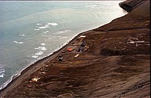
During World War II, the Luftwaffe placed a meteorological team there under cover of Operation Zitronella. Due to their remote location, the German soldiers on Hopen were the last in Europe to surrender to the allies, who had to in fact be rescued after losing radio contact almost 5 months prior. [5]

On August 28, 1978 an early model Tupolev Tu-16 of the Soviet Air Force crashed on the island. All seven crew were killed in the accident. It was discovered two days later by the four-man Norwegian weather forecasting team. The USSR refused to admit the loss of an aircraft until the bodies of the crew were given to them. Norway transcribed the contents of the flight recorder over the objections of the Soviet government. [6]

Environment

A significant number of polar bears are found at Hopen in the winter; [7] [8] moreover, the sub-population of Ursus maritimus found here is a genetically distinct taxon of polar bears associated with the Barents Sea region. [9] Since 2003, little sea ice has surrounded the island. [4]

Important Bird Area

The island has been identified as an Important Bird Area (IBA) by BirdLife International. It supports breeding populations of black-legged kittiwakes (40,000 pairs), thick-billed guillemots (150,000 individuals) and black guillemots (1000 pairs). [10]

Climate

Hopen has a tundra climate (Köppen climate classification ET). The average annual temperature in Hopen is −3.6 °C (25.5 °F). The average annual rainfall is 355.4 mm (13.99 in) with September as the wettest month. The temperatures are highest on average in August, at around 3.9 °C (39.0 °F), and lowest in March, at around −10.4 °C (13.3 °F). The highest temperature ever recorded in Hopen was 17.4 °C (63.3 °F) on 9 July 1973; the coldest temperature ever recorded was −36.9 °C (−34.4 °F) on 4 March 1986.

Climate data for Hopen (1991–2020 normals, extremes 1945–present)
MonthJanFebMarAprMayJunJulAugSepOctNovDecYear
Record high °C (°F)4.3
(39.7)
4.5
(40.1)
3.6
(38.5)
6.9
(44.4)
8.8
(47.8)
15.7
(60.3)
17.4
(63.3)
15.7
(60.3)
11.9
(53.4)
10.8
(51.4)
8.3
(46.9)
5.5
(41.9)
17.4
(63.3)
Mean maximum °C (°F)1.5
(34.7)
1.5
(34.7)
1.3
(34.3)
2.0
(35.6)
3.5
(38.3)
5.7
(42.3)
8.5
(47.3)
9.1
(48.4)
7.9
(46.2)
4.8
(40.6)
3.1
(37.6)
2.4
(36.3)
10.1
(50.2)
Average high °C (°F)−6.6
(20.1)
−7.1
(19.2)
−7.9
(17.8)
−5.7
(21.7)
−1.4
(29.5)
2.1
(35.8)
4.7
(40.5)
5.1
(41.2)
3.5
(38.3)
−0.1
(31.8)
−2.6
(27.3)
−5.0
(23.0)
−1.7
(28.9)
Daily mean °C (°F)−9.0
(15.8)
−9.6
(14.7)
−10.4
(13.3)
−8.0
(17.6)
−3.0
(26.6)
0.8
(33.4)
3.3
(37.9)
3.9
(39.0)
2.4
(36.3)
−1.4
(29.5)
−4.4
(24.1)
−7.2
(19.0)
−3.6
(25.6)
Average low °C (°F)−11.4
(11.5)
−12.0
(10.4)
−12.9
(8.8)
−10.3
(13.5)
−4.6
(23.7)
−0.6
(30.9)
1.8
(35.2)
2.6
(36.7)
1.3
(34.3)
−2.8
(27.0)
−6.1
(21.0)
−9.3
(15.3)
−5.4
(22.4)
Mean minimum °C (°F)−21.9
(−7.4)
−22.5
(−8.5)
−23.3
(−9.9)
−19.6
(−3.3)
−11.4
(11.5)
−4.0
(24.8)
−0.9
(30.4)
0.0
(32.0)
−1.9
(28.6)
−8.8
(16.2)
−14.1
(6.6)
−19.1
(−2.4)
−26.0
(−14.8)
Record low °C (°F)−35.5
(−31.9)
−34.6
(−30.3)
−36.9
(−34.4)
−30.2
(−22.4)
−22.2
(−8.0)
−9.9
(14.2)
−4.3
(24.3)
−4.4
(24.1)
−12.4
(9.7)
−29.0
(−20.2)
−31.7
(−25.1)
−35.6
(−32.1)
−36.9
(−34.4)
Average precipitation mm (inches)36.1
(1.42)
26.9
(1.06)
34.4
(1.35)
26.3
(1.04)
21.4
(0.84)
18.6
(0.73)
23.6
(0.93)
35.4
(1.39)
35.9
(1.41)
34.7
(1.37)
29.8
(1.17)
32.4
(1.28)
355.4
(13.99)
Average precipitation days (≥ 0.1 mm)20.4318.8619.7717.9316.8313.6014.3719.0020.8722.4721.1721.10226.07
Source: Météo climat [11] [12]

See also

Related Research Articles

<span class="mw-page-title-main">Jan Mayen</span> Norwegian island in the Arctic Ocean

Jan Mayen is a Norwegian volcanic island in the Arctic Ocean with no permanent population. It is 55 km (34 mi) long (southwest-northeast) and 373 km2 (144 sq mi) in area, partly covered by glaciers. It has two parts: larger northeast Nord-Jan and smaller Sør-Jan, linked by a 2.5 km (1.6 mi) wide isthmus. It lies 600 km (370 mi) northeast of Iceland, 500 km (310 mi) east of central Greenland, and 900 km (560 mi) northwest of Vesterålen, Norway. The island is mountainous, the highest summit being the Beerenberg volcano in the north. The isthmus is the location of the two largest lakes of the island, Sørlaguna and Nordlaguna. A third lake is called Ullerenglaguna. Jan Mayen was formed by the Jan Mayen hotspot and is defined by geologists as a microcontinent.

<span class="mw-page-title-main">Norwegian Sea</span> Marginal sea of the Arctic or Atlantic Ocean, northwest of Norway

The Norwegian Sea is a marginal sea, grouped with either the Atlantic Ocean or the Arctic Ocean, northwest of Norway between the North Sea and the Greenland Sea, adjoining the Barents Sea to the northeast. In the southwest, it is separated from the Atlantic Ocean by a submarine ridge running between Iceland and the Faroe Islands. To the north, the Jan Mayen Ridge separates it from the Greenland Sea.

<span class="mw-page-title-main">Polar bear</span> Species of bear native largely to the Arctic Circle

The polar bear is a large bear native to the Arctic and surrounding areas. It is closely related to the brown bear, and the two species can interbreed. The polar bear is the largest extant species of bear and land carnivore, with adult males weighing 300–800 kg (700–1,800 lb). The species is sexually dimorphic, as adult females are much smaller. The polar bear is white- or yellowish-furred with black skin and a thick layer of fat. It is more slender than the brown bear, with a narrower skull, longer neck and lower shoulder hump. Its teeth are sharper and more adapted to cutting meat. The paws are large and allow the bear to walk on ice and paddle in the water.

<span class="mw-page-title-main">Svalbard</span> Norwegian archipelago in the Arctic Ocean

Svalbard ), also known as Spitsbergen or Spitzbergen, is a Norwegian archipelago in the Arctic Ocean. North of mainland Europe, it lies about midway between the northern coast of Norway and the North Pole. The islands of the group range from 74° to 81° north latitude, and from 10° to 35° east longitude. The largest island is Spitsbergen, followed in size by Nordaustlandet and Edgeøya. The largest settlement is Longyearbyen on the west coast of Spitsbergen.

<span class="mw-page-title-main">Geography of Svalbard</span>

Svalbard is an archipelago in the Arctic Ocean roughly centered on 78° north latitude and 20° east longitude. The archipelago is the northernmost part of the Kingdom of Norway. The three main islands in the group consist of Spitsbergen, Nordaustlandet and Edgeøya. There are also a number of smaller islands, such as Barents Island (Barentsøya), Kvitøya, Prins Karls Forland, Kongsøya, Bear Island, Svenskøya, Wilhelm Island and other smaller islands or skerries.

<span class="mw-page-title-main">Barents Sea</span> Marginal sea of the Arctic Ocean, off the northern coasts of Norway and Russia

The Barents Sea is a marginal sea of the Arctic Ocean, located off the northern coasts of Norway and Russia and divided between Norwegian and Russian territorial waters. It was known earlier among Russians as the Northern Sea, Pomorsky Sea or Murman Sea ; the current name of the sea is after the historical Dutch navigator Willem Barentsz.

<span class="mw-page-title-main">Spitsbergen</span> Largest island of the Svalbard archipelago in northern Norway

Spitsbergen is the largest and the only permanently populated island of the Svalbard archipelago in northern Norway.

<span class="mw-page-title-main">Bear Island (Svalbard)</span> Southernmost island of Svalbard, Norway

Bear Island is the southernmost island of the Norwegian Svalbard archipelago. The island is located at the limits of the Norwegian and Barents seas, approximately halfway between Spitsbergen and the North Cape. Bear Island was discovered by Dutch explorers Willem Barentsz and Jacob van Heemskerck on 10 June 1596. It was named after a polar bear that was seen swimming nearby. The island was considered terra nullius until the Spitsbergen Treaty of 1920 placed it under Norwegian sovereignty.

<span class="mw-page-title-main">Franz Josef Land</span> Archipelago in the Arctic

Franz Josef Land is a Russian archipelago in the Arctic Ocean. It is inhabited only by military personnel. It constitutes the northernmost part of Arkhangelsk Oblast and consists of 192 islands, which cover an area of 16,134 square kilometers (6,229 sq mi), stretching 375 kilometers (233 mi) from east to west and 234 kilometers (145 mi) from north to south. The islands are categorized in three groups separated by the British Channel and the Austrian Strait. The central group is further divided into a northern and southern section by the Markham Sound. The largest island is Prince George Land, which measures 2,741 square kilometers (1,058 sq mi), followed by Wilczek Land, Graham Bell Island and Alexandra Land.

<span class="mw-page-title-main">Greenland Sea</span> Body of water

The Greenland Sea is a body of water that borders Greenland to the west, the Svalbard archipelago to the east, Fram Strait and the Arctic Ocean to the north, and the Norwegian Sea and Iceland to the south. The Greenland Sea is often defined as part of the Arctic Ocean, sometimes as part of the Atlantic Ocean. However, definitions of the Arctic Ocean and its seas tend to be imprecise or arbitrary. In general usage the term "Arctic Ocean" would exclude the Greenland Sea. In oceanographic studies the Greenland Sea is considered part of the Nordic Seas, along with the Norwegian Sea. The Nordic Seas are the main connection between the Arctic and Atlantic oceans and, as such, could be of great significance in a possible shutdown of thermohaline circulation. In oceanography the Arctic Ocean and Nordic Seas are often referred to collectively as the "Arctic Mediterranean Sea", a marginal sea of the Atlantic.

Miseryfjellet, at 536 metres (1,759 ft), is the tallest peak on Bear Island (Bjørnøya), a Norwegian island in the Barents Sea. Miseryfjellet is on the eastern side of Bear Island and contains three distinct component peaks, Urd, Verdande and Skuld. These peaks are named after the three Norns in Norse Mythology. The name Bear Island is derived from the seasonal presence of polar bears, Ursus maritimus, whose population in the Barents Sea region is a genetically distinct sub-population of this species.

<span class="mw-page-title-main">Barentsøya</span> Island in the Svalbard archipelago, Norway

Barentsøya, anglicized as Barents Island, is an island in the Svalbard archipelago of Norway, lying between Edgeøya and Spitsbergen. Barents Island has no permanent human inhabitants. Named for the Dutch explorer Willem Barents, it is a part of Søraust-Svalbard Nature Reserve.

<span class="mw-page-title-main">Kong Karls Land</span> Island group in Norway

Kong Karls Land or King Charles Land is an island group in the Svalbard archipelago, in the Arctic Ocean. The island group covers an area of 342 km2 (132 sq mi) and is made up of the islands of Kongsøya, Svenskøya, Abel Island, Helgoland Island, and Tirpitzøya.

<span class="mw-page-title-main">Cape Zhelaniya</span> Headland on Novaya Zemlya, Russia

Cape Zhelaniya is a headland in the Russian Federation. It is an important geographical landmark. The area in the vicinity of the cape is a desolate place, exposed to bitter Arctic winters. The cape along with the surrounding part of Novaya Zemlya is protected as part of Russian Arctic National Park.

Freeman Strait is the sound separating Barents Island, to the north, from Edge Island, in the Svalbard archipelago, Norway.

<span class="mw-page-title-main">Climate of Norway</span> Overview of the Climate of Norway

The climate of Norway is more temperate than could be expected for such high latitudes. This is mainly due to the North Atlantic Current with its extension, the Norwegian Current, raising the air temperature; the prevailing southwesterlies bringing mild air onshore; and the general southwest–northeast orientation of the coast, which allows the westerlies to penetrate into the Arctic. The January average in Brønnøysund is 15.8C (28.6F) higher than the January average in Nome, Alaska, even though both towns are situated on the west coast of the continents at 65°N. In July the difference is reduced to 3.2C (5.8F). The January average of Yakutsk, in Siberia but slightly further south, is 42.3C (76.1F) lower than in Brønnøysund.

<span class="mw-page-title-main">Climate of Svalbard</span>

Svalbard is a Norwegian archipelago in the Arctic Ocean. The climate of Svalbard is principally a result of its latitude, which is between 74° and 81° north. Climate is defined by the World Meteorological Organization as the average weather over a 30-year period. The North Atlantic Current moderates Svalbard's temperatures, particularly during winter, giving it up to 20 °C (36 °F) higher winter temperature than similar latitudes in continental Russia and Canada. This keeps the surrounding waters open and navigable most of the year. The interior fjord areas and valleys, sheltered by the mountains, have fewer temperature differences than the coast, with about 2 °C lower summer temperatures and 3 °C higher winter temperatures. On the south of the largest island, Spitsbergen, the temperature is slightly higher than further north and west. During winter, the temperature difference between south and north is typically 5 °C, and about 3 °C in summer. Bear Island (Bjørnøya) has average temperatures even higher than the rest of the archipelago.

Svalbard is an Arctic, wilderness archipelago comprising the northernmost part of Norway. It is mostly uninhabited, with only about 3,000 people, yet covers an area of 61,020 square kilometres (23,560 sq mi).

<span class="mw-page-title-main">Isfjord Radio</span> Radio station in Svalbard, Norway

Isfjord Radio is a coast radio station, weather station and hotel located at Kapp Linné on the island Spitsbergen in Svalbard, Norway. The station was established in 1933, and has played an important role in the telecommunications between the Svalbard archipelago and the outside world. The station was destroyed by both sides during World War II, and rebuilt in 1946. The station was important for ships traffic and air traffic. Satellite communications were established in 1979, but deprecated when a fiber optic cable between Svalbard and the mainland was finished in 2004. Isfjord Radio was automated and depopulated in 1999. Parts of the outdated installations have been preserved as a historical site.

<span class="mw-page-title-main">Hopen Radio</span> Coast radio station in Norway

Hopen Radio is a coast radio station and the only settlement on the island of Hopen in Svalbard, Norway. It is located between Kollerfjellet and Werenskioldfjellet.

References

  1. "Hopen". Ramsar Sites Information Service. Retrieved 25 April 2018.
  2. Svalbard Arctic out post at strategic crossroads September 9, 1980 Christian Science Monitor Retrieved August 15, 2017
  3. Umbreit, Andreas Bradt Svalbard: Spitzbergen with Frank Josef Land & Jan Mayen page 132 Retrieved August 15, 2017
  4. 1 2 "Hopen - The Cruise Handbook for Svalbard". cruise-handbook.npolar.no. Retrieved 2023-08-31.
  5. Farelly, Elly (2016-06-16). "These Germans Stationed Near The North Pole Were The Last To Surrender, In September 1945!". warhistoryonline. Retrieved 2023-08-31.
  6. Soviet Union Military Plane Crashes in Norway October 27, 1978 Retrieved August 15, 2017
  7. Derocher AE, Andersen M, Wiig Ø, Aars J, Hansen E, Biuw M. 2011. Sea ice and polar bear den ecology at Hopen Island, Svalbard. Marine Ecology Progress Series 441:273-279.
  8. Oysten Wiig and Kjell Isaksen
  9. C. Michael Hogan, 2008
  10. "Hopen Island". Important Bird Areas factsheet. BirdLife International. 2013. Retrieved 2013-08-22.
  11. "Moyennes 1991-2020 Norvege (Jan Mayen/Svalbard)" (in French). Retrieved 1 June 2022.
  12. "Météo Climat stats for Hopen". Météo Climat. Retrieved 1 June 2022.

Bibliography