Jan Mayen is a Norwegian volcanic island in the Arctic Ocean with no permanent population. It is 55 km (34 mi) long (southwest-northeast) and 373 km2 (144 sq mi) in area, partly covered by glaciers. It has two parts: larger northeast Nord-Jan and smaller Sør-Jan, linked by a 2.5 km (1.6 mi) wide isthmus. It lies 600 km (370 mi) northeast of Iceland, 500 km (310 mi) east of central Greenland, and 900 km (560 mi) northwest of Vesterålen, Norway. The island is mountainous, the highest summit being the Beerenberg volcano in the north. The isthmus is the location of the two largest lakes of the island, Sørlaguna and Nordlaguna. A third lake is called Ullerenglaguna. Jan Mayen was formed by the Jan Mayen hotspot and is defined by geologists as a microcontinent.

Svalbard, also known as Spitsbergen, or Spitzbergen, is a Norwegian archipelago in the Arctic Ocean. North of mainland Europe, it lies about midway between the northern coast of Norway and the North Pole. The islands of the group range from 74° to 81° north latitude, and from 10° to 35° east longitude. The largest island is Spitsbergen, followed in size by Nordaustlandet and Edgeøya. The largest settlement is Longyearbyen.

Bear Island is the southernmost island of the Norwegian Svalbard archipelago. The island is located in the western part of the Barents Sea, approximately halfway between Spitsbergen and the North Cape. Bear Island was discovered by Dutch explorers Willem Barentsz and Jacob van Heemskerck on 10 June 1596. It was named after a polar bear that was seen swimming nearby. The island was considered terra nullius until the Spitsbergen Treaty of 1920 placed it under Norwegian sovereignty.

The Tupolev Tu-16 is a twin-engined jet strategic heavy bomber used by the Soviet Union. It has been flown for almost 70 years, and the Chinese license-built Xian H-6 remains in service with the People's Liberation Army Air Force.

Operation Gauntlet was an Allied Combined Operation from 25 August until 3 September 1941, during the Second World War. Canadian, British and the Norwegian armed forces in exile landed on the Norwegian island of Spitzbergen in the Svalbard Archipelago, 650 mi (1,050 km) south of the North Pole.
The polar archipelago of Svalbard was first discovered by Willem Barentsz in 1596, although there is disputed evidence of use by Pomors or Norsemen. Whaling for bowhead whales started in 1611, dominated by English and Dutch companies, though other countries participated. At that time there was no agreement about sovereignty. Whaling stations, the largest being Smeerenburg, were built during the 17th century, but gradually whaling decreased. Hunting was carried out from the 17th century by Pomors, but from the 19th century it became more dominated by Norwegians.
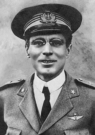
Umberto Nobile was an Italian aviator, aeronautical engineer and Arctic explorer.
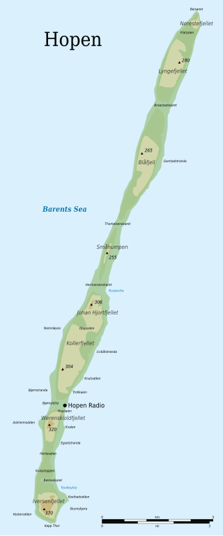
Hopen is an island in the southeastern part of the Svalbard archipelago (Norway). Hopen was discovered in 1596 by Jan Cornelisz Rijp during the third expedition by Willem Barentsz, trying to find the Northeast Passage. Later, in 1613, its name was given by Thomas Marmaduke of Hull, who named it after his former command, the Hopewell.

Operation Zitronella, also known as Unternehmen Sizilien, was an eight-hour German raid on Spitzbergen, in the Svalbard Archipelago, on 8 September 1943. The battleships Tirpitz and Scharnhorst, plus nine destroyers, sailed to the archipelago, bombarded Allied-occupied settlements in Isfjorden and covered a landing party. Six Norwegians were killed and 31 were taken prisoner; sixteen Germans were wounded, one dying of his wounds.

Svalbard lies under the sovereignty of Norway, but the Svalbard Treaty places several restrictions. Norway cannot use the archipelago for warlike purposes, cannot discriminate economic activity based on nationality and is required to conserve the natural environment. Uniquely, Svalbard is an entirely visa-free zone. Everybody may live and work in Svalbard indefinitely regardless of country of citizenship. Svalbard Treaty grants treaty nationals equal right of abode as Norwegian nationals. Non-treaty nationals may live and work indefinitely visa-free as well. "Regulations concerning rejection and expulsion from Svalbard" is in force on non-discriminatory basis.

Danes Island is an island in Norway's Svalbard archipelago in the Arctic Ocean with an area of 40.6 km2 (15.7 sq mi). It lies just off the northwest coast of Spitsbergen, the largest island in the archipelago, near to Magdalenefjorden. Just to the north lies Amsterdam Island. Most of Svalbard's islands, including Danes Island, are uninhabited; only Spitsbergen, Bjørnøya and Hopen have settlements.

Arktikugol is a Russian coal mining unitary enterprise which operates on the island of Spitsbergen in Svalbard, Norway. Owned by the government of Russia, Arktikugol currently performs limited mining in Barentsburg. It has carried out mining operations in the towns of Pyramiden and Grumant, which it still owns, and once operated a port at Colesbukta. The company is headquartered in Moscow and is the official agency through which Russia, and previously the Soviet Union, exercised its Svalbard policy.

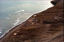
Isfjord Radio is a coast radio station, weather station and hotel located at Kapp Linné on the island Spitsbergen in Svalbard, Norway. The station was established in 1933, and has played an important role in the telecommunications between the Svalbard archipelago and the outside world. The station was destroyed by both sides during World War II, and rebuilt in 1946. The station was important for ships traffic and air traffic. Satellite communications were established in 1979, but deprecated when a fiber optic cable between Svalbard and the mainland was finished in 2004. Isfjord Radio was automated and depopulated in 1999. Parts of the outdated installations have been preserved as a historical site.

Kongsfjord Telemetry Station was a satellite ground station located nearby Ny-Ålesund in Svalbard, Norway. It was used between 1967 and 1974 as one of the four initial ground stations which were part of the European Space Tracking Network (ESTRACK) serving the European Space Research Organization's (ESRO) first generation of satellites. The station provided radio tracking, telemetry and commanding services as well as data download. Although owned by ESRO, the facilities were constructed and operated by the Royal Norwegian Council for Scientific and Industrial Research (NTNF).
Beisaren is the northernmost point of the island of Hopen in the Svalbard archipelago. It is named after hunter Berner Jørgensen, whose nickname was "Beisaren".
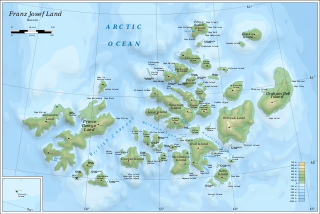
Franz Josef Land, an uninhabited archipelago located in the Arctic Ocean, Barents Sea and Kara Sea, may have been discovered by the 1865 expedition of the Norwegian sealing vessel Spidsbergen captained by Nils Fredrik Rønnbeck. However, the discovery was never announced and the existence of the territory only came to public notice following the Austro-Hungarian North Pole Expedition of 1872, which named the archipelago in honor of Franz Joseph I of Austria. Benjamin Leigh Smith led the next expedition in 1880, which continued the work of the first expeditions in investigating the southern and central parts of the archipelago. Concurrent expeditions followed in 1896, Nansen's Fram expedition and the Jackson–Harmsworth Expedition, which met by accident. These two journeys explored the northern area and the flanks of Franz Josef Land.

Barentsburg Heliport, Heerodden is a private heliport located at Heerodden, serving the mining town of Barentsburg in Svalbard, Norway. The airport is owned and operated by Arktikugol, which also owns the company town. The airport features a 91-by-21-meter runway, two hangars and an administration building with a control tower. There are two Mil Mi-8 helicopters based at Heerodden, which are operated by Spark+. Flights are provided to Svalbard Airport, Longyear and Pyramiden Heliport.

The 1954 Bjørnøya Consolidated PBY Catalina crash was a controlled flight into terrain (CFIT) of a Consolidated PBY Catalina on the island of Bjørnøya in Svalbard, Norway, on 28 March 1954 at ca. 15:00. The Royal Norwegian Air Force aircraft of No. 333 Squadron RNoAF was conducting a postal drop flight from Tromsø to five settlements on Svalbard, including Bjørnøya Radio, making a low pass over Bjørnøya at a height of 40 meters (130 ft) before crashing into the ground. Only one of the nine on board survived.
Kollerfjellet is a mountain at Hopen, Svalbard. It has a height of 304 m.a.s.l., and its first known ascent was made in 1924 during topographic works.
Werenskioldfjellet is a mountain at Hopen, Svalbard. The mountain is named after Norwegian geologist and Arctic explorer Werner Werenskiold.